BUSINESS MODELS FOR IMPLEMENTING GEOSPATIAL TECHNOLOGIES IN TRANSPORTATION DECISION-MAKING
Case Study Inventory of State Departments of Transportation
APPENDIX C: State DOT Case Studies
Alabama DOT Case Study
Contact: Mike Rief
Riefm@dot.state.al.us
Background
Alabama DOT's (ALDOT) GIS has grown significantly since the early 2000s. Prior to 2001-2, computer service staffers were the DOT's primary GIS users; there was no sustained, department-wide commitment to build an enterprise GIS. In 2001-2, however, DOT high-level management began to champion GIS as a key aspect of long-term planning. Initial data digitization efforts focused on collecting road centerlines and compiling this information into an online database. ALDOT's first GIS application was a video log viewer that presented road centerline data and digital front-view road photographs, offering users an opportunity to virtually "drive" state highways. Currently, the Department maintains a centralized geospatial database that supports several GIS applications, including TRANSVIEW, an expansion of the original video log viewer. Numerous divisions throughout ALDOT use these applications.
Business Model for Geospatial Technology Implementation
Organizational Structure
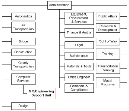
ALDOT's GIS program is the Engineering/GIS Support Unit within the Computer Services Bureau (see Figure 1). Presently, GIS staff is comprised of five state employees and seven contractors. Five additional contracting jobs are vacant. ALDOT has found that hiring temporary employees to fill these vacancies is not a viable solution due to high turnover rates. Furthermore, due to vacancies, ALDOT's GIS Group presently has less time to focus on application development and GIS expansion.
GIS staff members do not have pre-existing roles that are specified by a job description. Rather, staff members build on existing personal skills and/or acquired GIS knowledge to focus on particular projects. Staff members collaborate to develop all of ALDOT's geospatial applications, perform analyses, develop end-product maps for customers, and maintain a centralized database.
Relationship building is a major focus of ALDOT's GIS. For example, there is no formal data requisition process. Internal users contact the GIS unit (usually by phone) to request maps or technical support and the GIS unit responds appropriately. This informal method relies on the Department's ability to build and maintain a network of strong, collaborative relationships between staff members. To meet users' needs, the GIS unit emphasizes a customer-service-driven model: most data are shared upon request, and requests do not have to be articulated in a formal process.
Within the past two years (2006-2008), ALDOT has engaged in some very informal dialogue about the best organizational location for the GIS program. One suggestion has been to take GIS out of its current place in Computer Services and relocate it as a Bureau. Proponents of this scenario argue that GIS would be better able to meet users' needs if placed more centrally within the DOT. While ALDOT does not anticipate any immediate organizational change, it is acknowledged that such change may be inevitable in the future as more users seek access to GIS applications.
Figure 1. Alabama Department of Transportation Organization Chart, Central Office Complex - Bureau
Geospatial Data Acquisition
ALDOT has created its own ortho-rectified and mileposted centerlines and derivative networks, which include a measured network for linear referencing and separate lines for travel direction and lane counts. Current projects focus on upgrading GIS technology, acquiring new ortho-photographs/LiDAR, maintaining pavement data and photo logs, developing county routes, and aligning these route data with existing orthophotos. Raw data for these routes is acquired through private entities and state, government sources, and digitized as time, resources, staffing, and user needs dictate and allow.
Data Delivery and Policies
The Department maintains several notable geospatial applications, tools, and analyses, which include TRANSVIEW, a road video log viewing application with GIS functionality, the Traffic Counter Internet Map Server Pages, DGN Data Harvester, the Bridge Document Retrieval Program and the Maintenance Bureau's Permitting Map.
The Bridge, Maintenance, Transportation Planning, and Materials & Tests Bureaus are primary GIS users. Other important external users include the Alabama Department of Public Safety's Highway Patrol and county governments. The Highway Patrol, for example, has used the DOT's crash data and maps to better allocate enforcement resources to prevent collisions at crash-prone sites. The Department's Bridge Document Retrieval Program has increased the accuracy and usefulness of the ALDOT's bridge data and related documents (e.g., bridge cards), which were stored as hard copies or in separate unrelated databases.
Data owners set data-sharing policies, although most data are publicly accessible and/or freely shared upon request. Access to data purchased from third parties may be restricted depending on the owner's requirements. In addition, the Transportation Planning Bureau sets data creation policies. Such policies primarily affect the ways in which milepost maps for road centerline databases are created.
Currently, the GIS unit plans to create a Strategic GIS Proposal for further ALDOT management consideration. This proposal will address future policy needs of the Department as related to geospatial technologies, data acquisition, and application development. This proposal primarily serves to enhance long-term planning for ALDOT's GIS program, since the Department has historically focused on ad hoc application and data development rather than on meeting codified goals and objectives.
Funding
Beginning in 2001, the Computer Services Bureau provided salary funding for three GIS staff members. Currently, however, ALDOT relies on FHWA SPR (State Planning and Research) monies to support GIS staffing needs, but these funds are matched 80/20 with the State. SPR dollars are provided on a retroactive basis. ALDOT provides summary reports to FHWA to outline time spent on GIS projects, and FHWA then reimburses ALDOT for specific work deemed eligible for SPR funding.
ALDOT's annual budget for GIS activities is approximately $1.0M. In FY09, the FHWA, with ALDOT input, suggested a budget increase to $1.3M.
Benefits of GIS
While ALDOT has not completed a formal cost-benefit analysis for its GIS activities, it emphasizes that the benefit of geospatial applications has exceeded investment. GIS has specifically benefited departmental decision-making by allowing the DOT to develop a more effective and comprehensive Five Year plan and provide Interstate and State Route crash analyses to the Department of Safety and ALDOT staff.
Challenges
ALDOT has encountered some challenges in growing its GIS program:
- State employment classification schemes - The three official GIS merit system classifications have not met ALDOT's needs. The merit classification schemes stipulate that those hired for GIS work in all state agencies must have four-year degrees in Geography or a directly related field. However, ALDOT has determined through experience that entry-level and other GIS positions do not necessarily require individuals with four-year college degrees. In addition, ALDOT staff members with GIS expertise are excluded from applying for the existing GIS classifications due to the education constraints. Moreover, the state employment classification schemes have made it difficult for ALDOT to recruit and/or retain appropriate employees. The Department needs staff to expand its data collection efforts, but the schemes' educational requirements limit ALDOT's ability to move contractor vacancies to merit system classification jobs. The beginning GIS classification is commensurate for someone with a four-year "GIS" degree, but substantially too high for the large amount of entry-level work that is needed at ALDOT.
Prior to the creation of the three existing GIS Classifications, ALDOT proposed to the state Geographic Information Officer (GIO) a scheme with eight classifications ranging from entry level (e.g., "GIS Technician") to senior level (e.g., "GIS Manager II").This scheme would expand the Department's hiring ability as well as provide a means for converting contractors to merit system staff, but the proposal was ignored. ALDOT encourages ongoing conversation with the State Personnel Department and other state agencies to explore ways in which the classification scheme could be modified to address the DOT's wide range of GIS employment needs. - State contracting stipulations - Due to GIS Program development's unavoidable reliance on contracts and contractors, ALDOT could experience a 45-day delay in contract renewal(s) and thus lose those expert GIS staffers who are not able to financially absorb a 45-day employment hiatus.
- GIS 'identity crisis' - It is sometimes difficult to determine how GIS can best meet users' needs and expectations. ALDOT has informally considered the organizational location of the GIS Group and what would best assist ALDOT with maximizing the benefit of geospatial technologies. The inherent fluidity of GIS is both an advantage and disadvantage. GIS can meet multiple users' needs in a variety of ways and can grow and change as these needs fluctuate. At the same time, GIS may not have a clear core constituency within the department and the future of GIS services may rely on changes in customers' needs. The flexibility of GIS may therefore confound its ability to receive ongoing funding and high-level support.
Key Success Factors and Recommendations
- Relationship-based GIS - ALDOT's GIS program is based on a network of strong, cooperative relationships between staff members. This network allows for a certain degree of informality, as evidenced by the fact that there is no formal process in place for data requests. Such an informal system works well at ALDOT, but may not work at every DOT. It is important to consider the context of organizational culture and relationship networks when beginning (or growing) a GIS program.
- Develop user-friendly GIS applications - In order to ensure an efficient GIS program, application development should be based around users' needs and not simply on technological capabilities. In addition, maintaining one centralized GIS database will facilitate data management.
- Initiate new programs with care - The GIS staff has taken care, when feasible, to not 'do maps too fast.' They garnered support for GIS work by ensuring that new applications were intuitive for all users at every level of experience. In addition, ALDOT ensured that information was as correct and accurate as possible before allowing access to GIS applications, recognizing that new users who already have trepidation about GIS will be less inclined to use geospatial technologies if applications are not immediately accurate, user-friendly, and convenient. Within the DOT, GIS units should be extremely critical about their own projects in order to protect reputations for high-quality work.
- FHWA support - Gaining federal support is crucial to growing GIS programs at the state level. States must relay to FHWA the important contributions that GIS has in building more effective transportation decision-making. In turn, FHWA could help increase the visibility of DOT GIS programs.
Alaska Department of Transportation & Public Facilities
Contact: Kerry Kirkpatrick
Kerry.Kirkpatrick@alaska.gov
Background
The Alaska Department of Transportation & Public Facilities' (DOT&PF) GIS program grew out of an earlier paper mapping effort that was performed by the Mapping Section in the former Department of Highways. The GIS program developed from the ground up and has evolved since the late 1980s when the Mapping Section acquired GIS software. Although GIS capability was present in the late 1980s, lack of digital data made it challenging to fully utilize GIS functionalities. Nevertheless, the Mapping Section began digitizing road centerlines and attributes for a base road network to be used within a GIS. Prior to these digitization efforts, the state also used aerial imagery to create "static" paper maps. Since the late 1990s, the Mapping Section has initiated various GPS data-collection efforts that have helped solidify a comprehensive, controlled digital transportation network as a foundation for a GIS. The Section, which is now called the Statewide GIS/Mapping Section, later migrated GIS functionalities to the ESRI products suite. Current efforts involve maintaining, updating, and expanding the state GIS network and promoting a move towards an enterprise GIS solution. Furthermore, the Section is working to develop web-based geospatial applications to provide data to users both inside and outside of the Department.
Business Model for Geospatial Technology Implementation
Organizational Structure
The Statewide GIS/Mapping Section is located in the Division of Program Development, which was formerly known as the Division of Statewide Planning. This office serves as the core statewide GIS group that promotes, coordinates, and implements GIS within the Department and is located at DOT&PF headquarters in Juneau. The GIS/Mapping Section employs 3 full-time staff, most of whom have backgrounds in geography/GIS.
Data Collection, Delivery, and Policies In the early 2000s, the Statewide GIS/Mapping Section began to build a digital road network by driving the state with stand-alone GPS units to capture centerlines and various attributes of all drivable roads in the state. This collection method provided useful information, but the Section was overwhelmed with information as there were only a few staff to quality-check all data and build data into measured polylines.
Over the past several years, the Section has utilized new data collection methods and equipment that more accurately and efficiently gather centerline and road inventory data. These new methods garnered departmental support for building, expanding, and maintaining a stable GIS environment and moving toward an enterprise system. AK DOT&PF has also hired contractors to recommend, plan, and implement a transportation network geodatabase that utilizes an established LRS and select business data.
AK DOT&PF is primarily responsible for the state's transportation infrastructure, but relies on other agencies, including the U.S. Geological Survey (USGS) and the state Departments of Natural Resources, Commerce, Community and Economic Development, Environmental Conservation, and Fish and Game to provide background data layers. Initially, local governments and villages did not have any geospatial data to offer, but cooperated with the DOT&PF as they established more sophisticated systems. The Department has also participated in agreements with other agencies to obtain geospatial information and will continue to foster collaborative relationships with other groups across the state for data-collection and sharing purposes. The majority of the data that the AK DOT&PF obtain are collected in the field. Data are not bought, since historically, there has not been any purchasable geospatial transportation data for Alaska.
In the past, many of the Department's current GIS projects and/or applications have been based on static mapping that could not be updated in real-time. However, real-time application development is ongoing and in the next several months, AK DOT&PF will initiate work to connect its new geo-database environment to the web. Initially, applications from this geodatabase may offer only basic functionalities, but the Department will focus on increasing and expanding their capabilities over time. Ultimately, AK DOT&PF anticipates that applications will offer seamless real-time updates and analyses.
Most recently, the statewide GIS/Mapping Section initiated a Digital Imaging Data Collection photolog program. The photolog, which is web-accessible to internal DOT&PF users, displays spatially-accurate and linear-referenced images. From these images, the GIS/Mapping section can source network updates and extract feature information for integration into the enterprise geospatial database. While still in its early stages, this project has offered encouraging results to date: user response has been positive, and use of the photolog has increased.
The Department's GIS users are spread throughout the state in regional offices. While some users have standalone licenses, others utilize concurrent-use licenses that the GIS/Mapping Section makes available through the network. The user population will likely expand as AK DOT&PF uses a phased approach to improve database connectivity and further establishes an enterprise system.
Current work efforts focus on creating and enhancing an enterprise system, which involves expanding the digital road network (to include higher functional class and local/village roads), creating enhanced web-based GIS applications for public and internal consumption, and migrating the department's business data to these applications. The GIS/Mapping Section will continue to use and rely on consultants and contractors to supplement staff labor-hours and support complex project development. Many of the DOT&PF's systems involve leading-edge technology. Consultants have contributed GIS-T expertise in linear-referenced networks and dynamic segmentation to support all steps of project development. Contractors provide technical expertise to integrate data with new soft/hardware, convert tabular data to GIS format, and build new enterprise applications for data display.
Funding
Funding is allocated through AK DOT&PF's Program Development Division as an Annual Work Program (AWP). The AWP funds the GIS/Mapping Section's day-to-day operations (e.g., personnel services, software, commodities, and other small procurement activities). AWP funds, however, are insufficient for major program development initiatives such as planning and implementing the geospatial database, data collection activities, and application and web development. These types of activities are funded through other federal and state monies through the State Transportation Improvement Plan (STIP).
Challenges
AKDOT has encountered several challenges in growing its GIS program:
- STIP funds - Each time the STIP is updated or amended, GIS development projects have to be re-evaluated along with other transportation projects. There is always some risk that GIS money may be used for a higher-priority transportation-related project.
- Small GIS Office - The relatively small size of the GIS/Mapping office has made it challenging to promote GIS, establish a comprehensive GIS transportation network, and plan, establish, and implement an enterprise geodatabase. The GIS/Mapping Section has frequently became overwhelmed with information while collecting geospatial data, and the Section's prior need to build digital data from the ground up also compounded these difficulties. In addition, collaboration with other agencies to collect, process, and manage data has historically been difficult as many boroughs, cities, and/or villages did not have a well-developed GIS. To overcome some of these issues, the Section will incorporate more efficient ways to collect data. Furthermore, as other agencies begin to establish GIS programs, it will likely become easier for the GIS/Mapping Section to collaborate with others on data-collection and processing efforts.
- Setting a Precedent for Enterprise Development and Collaboration - During enterprise development, GIS "pockets" have appeared throughout various offices as users create their own GIS applications to meet business needs. To some extent, there is a perception that the Section's development of an enterprise approach compromises users' autonomy. As a result, it has been challenging to obtain users' full acceptance of an enterprise approach and ensure enterprise systems' compatibility with extant applications. The Section has recognized the importance of departmental outreach and communication as ways to address this perception. The Section anticipates that the recent geodatabase project will model an enterprise application and set a precedent for collaboration with all department and state GIS users. The geodatabase removes from the Section the responsibility to maintain/create a GIS network and, moreover, provides a base foundation for enterprise development.
- Mainframe hardware - Much of AK DOT&PF's business data (such as HPMS and accident data) are now stored in tabular form on a mainframe database, the Highway Analysis System (HAS), which was developed and implemented in the 1980s. The GIS/Mapping Section must go through a complex series of steps to ensure compatibility with the outdated HAS. The DOT&PF's long-term goal is to migrate all mainframe data to an enterprise database, but achieving this goal will be difficult because the HAS is entrenched in the Department's organizational and operational setup. In general, the need to synchronize new applications with the existing HAS has created difficulties and inefficiencies in AK DOT&PF's work towards an enterprise system.
Key Success Factors and Recommendations
- Showcase GIS products - When building a GIS program, efforts should be incremental and users should be patient. Showcasing project accomplishments and end products are important step towards building widespread trust and interest in the technology. Highlighting incremental progress makes it easier to gain high-level support for a GIS program. In particular, incorporating visual elements (e.g., graphs, charts, displays) into outreach and marketing efforts helps to model the benefits of GIS to potential users.
- Have a long-term building plan - AK DOT&PF has acknowledged that creating an original road network system is a complex process that requires a significant amount of time and resources but is also a necessary and crucial step to establishing and maintaining a robust GIS. State DOTs that are initiating GIS programs from the ground up should prepare a long-term implementation plan to address ways to create an original road network. This plan will help garner support from high-level decision-makers as well as a broad community of potential GIS users.
Arkansas State Highway and Transportation Department Case Study
Contacts: Robert Fuhler, 501-569-2631
Robert.Fuhler@arkansashighways.com
Greg Nation, 501-569-2406
Greg.Nation@arkansashighways.com
Background
The Arkansas Highway and Transportation Department's (AHTD) Environmental Division has played an integral role in expanding GIS use throughout the Department. In the early 2000s, the head of the Environmental Division was interested in technology that would streamline the NEPA process. Staff within the Environmental Division had been utilizing some GIS and understood the beneficial role that a more comprehensive GIS could play in this process. After researching and developing a method, the Division moved ahead with the process. To encourage high-level administrative support for GIS, the Division developed and presented GIS capabilities and the positive results gained from the technology.
Business Model for Geospatial Technology Implementation
Organizational Structure
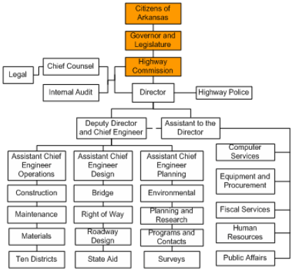
AHTD does not have a centralized GIS program (see Figure 2). Rather, staff in multiple areas, including the Planning and Research, Environmental, Programs and Contracts, Roadway Design, and Right of Way divisions, performs varying levels of GIS functions as part of their regular job tasks. Day-to-day GIS responsibilities are fragmented throughout the Department, and the level of use and staff expertise regarding GIS varies from one Division to the next. The Computer Services Division, however, is responsible for the acquisition of software, as well as populating and managing the central data repository.
Figure 2. Arkansas Highway and Transportation Department Organization Chart
Most of AHTD's Divisions have one or two staff members working on GIS activities, with the exception of the Environmental Division, which has a recognized GIS Section with a staff of seven. In 2003, early successes in using GIS to improve its environmental processes allowed AHTD to receive state legislative support to create the Section. The Section is responsible for not only the application of GIS-related data and its incorporation into transportation projects, but also houses Global Positioning Systems (GPS) technologies and assists staff with computer-related questions. Staff within Environmental Division's GIS Section often assist other Divisions with data coordination, implementation and provide GIS/GPS training.
Data Availability
AHTD acquires spatial data from a variety of sources. One of AHTD's primary data sources is GeoStor11, an enterprise-class state GIS data clearinghouse. The Arkansas Geographic Information Office (AGIO), a statewide agency responsible for coordinating geospatial activities in all levels of government and the private sector, maintains GeoStor. GeoStor's data distribution function allows local, state and federal agencies to store and publish the digital map data they produce for other entities to use. GeoStor currently has over 500 data layers, including elevation, transportation, site data, hydrology, soils and satellite imagery. At times, AHTD requires spatial data that is not available through GeoStor. For such projects, Environmental Division field staff will collect data using GPS and post-process those data into the GIS. A very good example of this method, as well as interagency coordination, was the Ivorybill Woodpecker Survey undertaken in a Wildlife Management Area in eastern Arkansas.
Internal access to spatial data is fairly unrestricted, except for specific proprietary data such as endangered species and archaeological site locations. AHTD is currently working to increase its internet GIS capabilities in order to further facilitate the use of GIS throughout the Department.
Funding
Each Division's GIS work is funded independently. As a result, there are a variety of funding sources. The Planning and Research Division receives Federal SPR funds, while the Environmental Division's GIS Section is funded through Federal Grants and AHTD's operating budget, which relies on revenue from transportation-related taxes.
Challenges
Some difficulties AHTD faced in the development of its GIS activities include:
- Lack of standardized data-sharing policies - Early on, intra- and inter-department data-sharing was difficult because departments were reluctant to share data over which they felt ownership. Moreover, departments feared that data-sharing would undermine their autonomy. The coordinating role played by the Arkansas Geographic Information Office (AGIO) has greatly improved collaboration between state agencies.
Key Success Factors and Recommendations
- Acquire High-Level Management Support - Securing support from Upper Administration played a pivotal role in the growth of GIS within the Environmental Division. Equally as important, securing support from the Department's Administration was a critical factor to secure the funding needed to undertake GIS activities.
- Educate staff about the capabilities of GIS - GIS is a relatively new and specialized technology. As a result, many transportation professionals are unaware of the valuable role that GIS can play in their work. When encouraging department-wide acceptance of a new convention like GIS, it is important to ensure that people understand and believe in its benefits.
California DOT Case Study
Contact: Oscar Jarquin
Oscar_Jarquin@dot.ca.gov
Background
The California DOT's (Caltrans) GIS program started in the late 1980s, at which time it was housed in the Planning Division and primarily supported planning activities. Over the next 10-15 years, Caltrans continued to grow its GIS program while also collecting geospatial information for surveying and CAD-based systems. In 2001, an executive-level GIS management committee addressed how GIS could support department-wide business needs. The committee chartered a technology working group to examine ways to build the GIS program. In 2002, high-level management established the Office of GIS as a focal point for GIS activities. An executive directive also specified that this Office would have the authority to coordinate the GIS program across departmental divisions. The directive broadened the department-wide visibility of GIS and promoted GIS coordination (via an enterprise system).
Business Model for Geospatial Technology Implementation
Organizational Structure
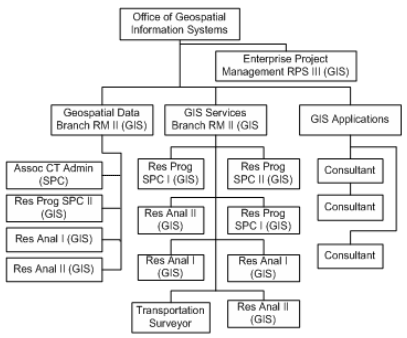
The Office of GIS (the 'Central Office') serves as a focal point for GIS at Caltrans (see Figure 3). The Office has 15 staff positions; currently, however, there are 7 staff vacancies. Hiring has been slowed by state-wide employment policies that limit GIS position descriptions, restrict who is eligible to apply for vacant positions, and determines when the positions can be posted.
Figure 3. California Department of Transportation Office of Geospatial Information Systems Organization Chart
Caltrans also employs GIS coordinators at the district level. Each of Caltrans' 12 districts has between 1 and 5 GIS Coordinators, depending on the district's size. In addition, each business division within Caltrans (e.g., the Maintenance and Operations Division) has a GIS Coordinator. At any given time, there are a total of 40-50 Caltrans employees working on GIS throughout the state.
Central Office employees have GIS classifications. However, at the district level, approximately 2/3 of the GIS coordinators have backgrounds in civil engineering or surveying, while the remaining 1/3 have backgrounds in planning or geography. On-site contracting is used on a project-by-project basis.
The Central Office performs several tasks, which include:
- Coordinating the enterprise program;
- Distributing software to users; upgrading software when needed;
- Maintaining a statewide base layer map, an enterprise geo-database, and numerous browser-based applications;
- Managing districts' input regarding suggestions for data collection, etc.;
- Maintaining partnerships between Central and district offices; assisting district offices with GIS projects as necessary.
The creation of the Central Office has had positive effects across the Department and has been well-received. For example, one effect of consolidation (as promoted by the Central Office) has been the development of closer partnerships between the central and district offices, as well as greater emphasis on customer service. At the same time, consolidation has not been dogmatic, and both districts and divisions retain autonomy to use their own geospatial applications/systems as they see fit. Caltrans' general philosophy is that GIS is a tool that can help accomplish various business requirements, but it is not a mandate.
Currently, the Central Office has developed an enterprise architecture for GIS. This work involves identifying and accessing appropriate software that can provide an enterprise infrastructure and also modeling an enterprise system for districts to follow. Another project involves potentially moving GIS application development functions from the Office of GIS to IT. Such a move would allow the Central Office to focus on decision-making and customer service, rather than on technological support and maintenance. Caltrans is also working to update the state's GIS employment classifications, which would make GIS positions more competitive with IT positions. Finally, cross-state collaboration is an important current and future direction for Caltrans. The Department has already started to work with neighboring state DOTs (in particular, Oregon and Nevada) to display geospatial information on a regional (rather than state-specific) basis. For example, the CA 511 traffic information system now offers data for Oregon and Nevada as well as the San Diego/northwestern Mexico region to help travelers plan state and/or international border-crossing trips.
Caltrans maintains a GIS Strategic Plan to provide direction for future growth. The strategic Five-Year Plan identifies trends in GIS use, recommends policy changes based on these trends, and is updated on an annual basis. The Central Office does not anticipate changes in its current emphasis on a customer service-based business model and working towards an enterprise GIS architecture. However, the Office does anticipate moving its application development function to the DOT's IT office while retaining the project management role.
The Office also anticipates an organizational shift with the coordination of the Department's official LRS. Currently, the LRS postmile system is maintained in tabular form; the Office of GIS translates postmile data to geometrical format and then publishes the data to a web service. Under the new proposed structure, the Office of GIS would take on responsibility for producing and maintaining the postmile system and would reassign necessary staff to the Office of GIS.
Geospatial Data Acquisition
The Central Office maintains over 100 geospatial data layers, some of which are provided by the districts. Data collection is ongoing and occurs as part of regular business practices. Data are gathered through a variety of sources, including public/private partnerships (see section below for more information). In an effort to limit data redundancies and promote data-sharing practices, Caltrans also participates in statewide collection initiatives initiated by the California Spatial Information Library12 (CaSIL) - an online repository of statewide geospatial information - and the California Mapping Coordination Committee (CMCC).
Public/Private Partnerships
Caltrans manages several data layers through partnerships with private enterprises. For example, Caltrans contracts with Tele Atlas for the Dynamap product, which includes a commercial road base for the entire state of California. To facilitate DOT access to Dynamap, Caltrans extended its contract agreement to specify that Tele Atlas would maintain Caltrans data attributes in a separate base product. Each quarter, Caltrans provides Tele Atlas with the most recent State Highway System (SHS) geometry and attribute updates. Tele Atlas then conflates their database with this information and returns the updated product to Caltrans. Currently, Caltrans is updating the contract agreement to facilitate data-sharing between Caltrans and other state/federal agencies. The updated agreement will also specify that Caltrans may provide public access to a three-year-old dataset (stripped of proprietary Tele Atlas data) that contains Caltrans-provided attributes. This public/private partnership has allowed Caltrans to develop an extremely accurate and comprehensive state road layer, which both government agencies and the public can access and share.
Data Delivery and Policies
Caltrans offers several browser-based applications, as well as an enterprise geo-database. Applications include California OneMap, the Oracle/ArcSDE road database that conflates purchased Tele Atlas data with state data to make customized maps, a Bond Accountability website, CA 511 (a public website providing travel and traffic information, which is 95% complete), and dynamic segmentation13 through a service-oriented architecture (SOA). Most browser-based applications utilize open-source software and XML (including GML and KML) formats are used extensively for data transfer. Most data can be accessed both internally and externally, but some data purchased from private sector companies are proprietary. Data requests come from within Caltrans, other state and local government agencies, and the public. Caltrans is committed to addressing external users' needs using a variety of sources.
Caltrans is a certified ESRI training center and funds and staffs in-house ESRI training. The Central Office collaborates with the Geotechnical Data Management Committee (GDMC) within Caltrans to set various data collection and data sharing policies. The GDMC was formed in 2004 for the purpose of managing, coordinating, and guiding geospatial information development in Caltrans.
Caltrans is currently implementing Google Earth Enterprise as a means of delivering basic GIS functionality to casual users and to support information delivery to the public.
Funding
SPR monies fund the Central Office, but each district and program funds their own GIS coordinator positions. The Central Office has to apply for SPR funds every year, but it has been a fairly reliable funding source. Caltrans estimates that it spends $2M per year (including salaries) on the core GIS program. In addition, the Office of GIS provides database and application development services to the functional unit within the department, and at any given time, the Office of GIS is working on multiple projects funded by the functional units. Collectively, the functional units provide an additional $500K to $1M per year to the budget of the Office of GIS. Furthermore, GIS activities at the district- and program-levels invest an estimated $2M per year. Caltrans invests approximately $5M on clearly identified GIS activities per year and, indirectly, a minimum of $10M though geospatial data development.
Benefits
GIS has significantly contributed to a broad range of Caltrans projects and has facilitated public outreach/input processes.
Challenges
- Statewide employment classification scheme - Caltrans has found it difficult to attract staff with the requisite skills and background. In part, this difficulty reflects the national shortage of individuals with high-level GIS skills. However, the statewide employment classification scheme also presents some challenges since position descriptions are developed for use throughout the state governments and thus do not always reflect Caltrans' needs.
- Hiring qualified candidates -Caltrans is required to hire using GIS classifications, and one potential source of eligible candidates would be students who complete internships with Caltrans (and who are listed on the state's eligibility list for state jobs). However, according to the current classification scheme, these students are in fact not eligible for state employment immediately after completing their Caltrans internship, as the statewide classification scheme does not consider the internship to fulfill the requisite 'experience.' Hiring student interns for permanent positions is also further complicated by the state Civil Service process. When former interns are not eligible hires (for example, when newly-graduated interns are unable to immediately take the Civil Service exam) , Caltrans must compete with both the private and public sector to fill vacancies with other qualified GIS professionals.
Key Success Factors and Recommendations
- Ensuring good customer service - As GIS becomes more visible and its reputation grows, there is increasing executive-level support for utilization of this tool. However, it is important that DOTs continue to emphasize customer service even after the initial GIS architecture has been put into place. Building a positive department-wide reputation requires first taking small steps to ensure product quality and ensure that products are meeting customers' needs and expectations.
- Keep organization's business needs at the forefront - The emphasis on enterprise GIS means that the Central Office must balance a need to focus on its own business missions with the desire and need to assist with district-level GIS programs. The Central Office also takes care to keep itself a neutral party in decision-making processes. Maintaining a balance between business needs and user requests is crucial to maintaining the integrity of the DOT's GIS program. To aid this balance, Caltrans recommends that DOTs should not engage in discourse about 'GIS needs,' but should emphasize the 'business needs that can be supported through GIS.' For example, in its strategic Five-Year Plan, Caltrans does not discuss GIS as a stand-alone technology, but as a tool that can 'support,' 'consider,' and 'facilitate' other business needs of the organization.
- FHWA support of standardization- The FHWA should emphasize the importance of technology and data standards to enable disparate systems across states to be compatible. The FHWA requirement that all states digitally submit HPMS data beginning in 2010 specifies a set of format standards for data submissions. However, these format standards differ from current standards. Caltrans expressed concern that these changes would be met with resistance from many state DOTs and may result in significant workload increases as states 're-learn' the submittal process. In addition, formatting systems may not be compatible across states. For states with advanced GIS capabilities, the FHWA requirement could essentially represent a technology 'backtrack' since regional (cross-state) GIS data already exists. FHWA support of technical systems, such a messaging service, would help promote a more fluid, regional geospatial perspective.
Colorado DOT Case Study
Contact: Marvin Koleis
Marvin.Koleis@dot.state.co.us
Background
The Colorado Department of Transportation (CDOT) has utilized geospatial technologies since 1985. In the early 1980s, efforts to build an automated mapping support capacity focused on CAD-based systems and Auto-Trol software and hardware products. As the technology advanced, high-level management looked to GIS and ESRI products as potential alternatives to CAD systems.
In the early 1980s, two state departments-the Department of Local Affairs (DOLA) in the Division of Local Government and the Colorado Division of Wildlife- began GIS program areas. The Colorado Division of Wildlife's program was a grid-based GIS called SAGIS. DOLA specifically used GIS to support the statewide mapping program and redistricting efforts that occurred after the 1980 Census. An initial redistricting application did not succeed and DOLA re-oriented its activities to support a departmental program called the Conservation Trust Fund, which allocated funding to local governments in the state for park and recreation services. Since the funding was allocated on a per capita basis, GIS was used to develop annual population estimates. While the initial application of GIS in DOLA did not succeed, the lessons learned from this experience were shared with CDOT. This knowledge helped CDOT avoid repeating DOLA's earlier mistakes.
In the mid-1980s, CDOT approached the state DOLA, which had been an early adopter of ESRI products,14 to learn more about best practices for GIS implementation. The Department of Local Affairs consulted with CDOT on a strategy to build CDOT's GIS program from the ground up. High-level departmental support for GIS also emerged, allowing CDOT to emphasize applications of GIS to transportation planning, especially for the Highway User Trust Fund (HUTF), the Highway Performance Monitoring System (HPMS), and Colorado's state travel map. CDOT took several steps to grow the program, initially purchasing data from private vendors, completing in-house digitization of several themes on the USGS 1:24,000 topographic series for Colorado, and purchasing ESRI software. Over the next several years, CDOT's GIS program grew while supporting several individual projects.
Most recently, CDOT implemented an enterprise application using SAP software and integrated ESRI ArcIMS technology with SAP to support project management. Other emerging initiatives at CDOT include utilization of mobile GIS, integrating spatial technology use with the Maintenance and Operations business unit, especially to support emergency management, and use of GIS to graphically display and maintain road closure information.
Business Model for Geospatial Technology Implementation
Organizational Structure
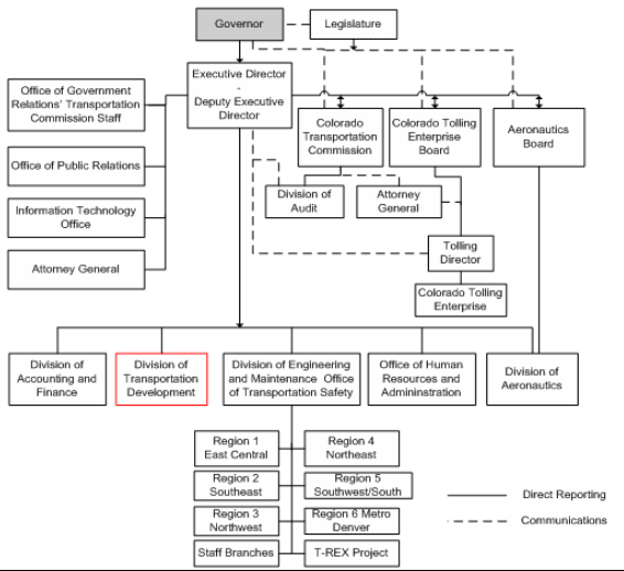
CDOT's GIS unit is located in the GIS/Information Management Section of the Division of Transportation Development (DTD) (see Figure 4). There are 200 to 250 users of ArcView software across the DOT. Other users of GIS and ESRI software in state agencies include the Departments of Natural Resources, Public Health and Environment, and Local Affairs.
Figure 4. Colorado Department of Transportation Organization Chart
The GIS/Information Management Section employs 17 full-time staff. Staff responsibilities include data collection, digitization of geospatial features, database and base map management, and mapmaking. CDOT contracts out some data collection work (especially regarding highway geometrics). When hiring new staff, CDOT looks for individuals with strong backgrounds in geography, planning, engineering, and/or IT. Most new employees have prior experience with or technical knowledge of GIS.
Currently, there is a statewide effort to coordinate geospatial data activities within the Governor's Office of Information Technology. This approach is proceeding according to the approach outlined in the "50 States Initiative," a business model for geospatial technology implementation developed by the Federal Geographic Data Committee (FGDC). The 50 States Initiative recommends steps for implementing geospatial systems across a statewide enterprise GIS system.15
CDOT notes that there are advantages and disadvantages to statewide GIS consolidation and is cautious in its support of consolidation efforts. For example, consolidation might undermine an individual agency's autonomy to use GIS to meet business objectives and may not be the most effective strategy to meet GIS users' needs. CDOT takes care to ensure that federal transportation monies are not diffused among various state agencies to support statewide GIS consolidation efforts instead of being expended, as they should, to directly support CDOT's mission.
While CDOT does not anticipate any imminent organizational change regarding GIS activities, it does acknowledge a general, national trend for GIS to move to an IT-based business unit. In Colorado, there is a current initiative to consolidate all information technology assets under the Governor's Office of Information Technology.
Geospatial Data Acquisition
There is no formal, codified data acquisition policy in place at CDOT. Ideas regarding data collection are generated and shared throughout the Department. However, there is an executive management team that provides leadership on how to approach large or complex issues. To facilitate long-range planning, CDOT collaborates with Metropolitan Planning Organizations (MPOs) and regional staff to broaden datasets.
Data are collected from various sources, including all levels of government (such as cities and counties), and from other state Departments when necessary (many of which collect their own data). CDOT coordinates and collaborates with local governments in Colorado to share spatial and tabular roadway data to support the Highway Users Trust Fund, which is the state gas tax mechanism to fund state and local roadway maintenance and improvements. Purchased proprietary data consists primarily of environmental datasets (e.g., underground storage tanks).
Data Delivery and Policies
CDOT has built several applications, the most recent of which has been enterprise resource planning (ERP). The ERP offers a web-mapping interface to allow managers to enter and track locational information and other aspects of transportation construction, maintenance, environmental, long-range planning, and STIP projects. Managers can quickly and efficiently access data that they would have previously obtained by visiting project sites. Other applications include Corridor Studies, which support the environmental review and permitting process, allowing users to search for information regarding construction and improvement projects within a particular corridor. A photograph log supports other parts of the DOT, including the Division of Engineering and Maintenance and the Office of Transportation Safety. The Traffic Operations Center (TOC) has added real-time data to the geospatial base map to provide information on travel times and traffic. CDOT also uses Straight Line Diagramming to display roadway characteristics in a straight graph 'strip map' format; this map also carries the base location information for the Linear Referencing System (LRS).
Users can access data via regional servers and desktop versions of ArcView. CDOT provides both ArcView training to encourage user autonomy as well as customized support when necessary. Alternatively, users can add their own data to existing DOT infrastructure applications in order to meet individual needs. Currently, CDOT is working to collaborate more closely with TOC and the Intelligent Transportation Systems (ITS) unit to maintain base data and render maps. In general, collaboration across divisions is an important business practice that CDOT uses to ensure data consistency.
Data are shared both internally and externally upon request, although proprietary data (i.e., data purchased from third parties) may be subject to some sharing restrictions depending on the contract terms.
Funding
SPR monies are a fairly reliable funding source for GIS activities within DTD. Contract money is also allocated for other purposes.
Challenges
Some obstacles that CDOT has encountered while growing its GIS program include:
- Ensuring data-sharing standards across the Department - When sharing data department-wide, it is challenging to ensure a base level of standards. However, it is organizational culture and not technology that ultimately shapes policies regarding data-sharing. For example, in the past, CDOT had hired contractors to complete construction or maintenance projects, but the contract terms did not specify that data collected during these projects would be delivered to CDOT upon project completion. It is important to consider organizational expectations and culture when negotiating contracts and creating data-sharing policies.
- IT business model for GIS - CDOT noted a national trend towards locating GIS in IT divisions/units and expressed concern about 'scripted' national efforts to have statewide GIS implementations follow nationally-developed criteria. Moving GIS to an IT unit would potentially constrain the Department to focus its business mission on providing technical assistance on GIS rather than focusing on GIS applications that can support transportation planning projects. In addition, a move to IT would potentially disrupt employees' roles and classifications: currently, CDOT's GIS staff members are viewed as "practitioners in support of transportation planning and development" and not necessarily as "information technologists."
- Contradiction of cost-benefit analysis - Colorado has not completed a formal cost-benefit study to assess its GIS programs; cost-benefit analyses of GIS do not appear to be a national-level priority. While completing a cost-benefit analysis is difficult and expensive, there is a need for data and studies to support claims regarding GIS models. For example, states are encouraged to adopt the 50 States Initiative model, which promises greater efficiencies in the cost of developing and maintaining spatial data. However, justification for the 50 States Initiative model is presented anecdotally, since data to support the model's benefits are lacking.
Key Success Factors and Recommendations
- Focus on business practice - CDOT emphasizes the importance of using GIS to meet agency business needs and objectives. The Division of Transportation Development, which houses GIS, took care to focus on priority transportation projects even while sharing data to support various needs across the DOT. In addition, the Division ensured that personnel stayed focused on transportation planning work. Maintaining a focus on business needs/objectives will help to grow an efficient and effective GIS program.
- Good initial plan for GIS - When initiating a GIS program, purchasing data up-front (rather than collecting data at the ground level-an expensive and time-consuming process) so that the DOT can focus its efforts on application development rather than data collection. The DOT can quickly obtain meaningful analyses from these applications, encouraging early support of and trust in the technology. Furthermore, DOTs should consider utilizing the whole spectrum of geospatial technologies, which may include aerial imagery, remote sensing, and/or GPS systems in addition to GIS. To the greatest extent possible, DOTs should use geospatial technologies (and not just GIS) to meet the specific business needs of the agency.
Connecticut DOT Case Study
Contact: Jim Spencer, (860) 594-2014
James.Spencer@po.state.ct.us
Background
The Connecticut Department of Transportation (ConnDOT) has used GIS in some format since the early 1980s. Historically, GIS has been application-centric and based on individual program needs. As a means to move beyond this application-centric system, in 2004, ConnDOT initiated plans to develop a new ESRI-based system from which an enterprise-wide GIS system could evolve. This system, which is currently under development, will incorporate all existing GIS applications into one system that will be accessible to all levels of users via the intranet.
Business Model for Geospatial Technology Implementation
Organizational Structure
ConnDOT's GIS functions are located in the GIS/Computer Systems Section, which is part of the Bureau of Policy and Planning (see Figure 5).
Figure 5. Connecticut Department of Transportation Organization Chart
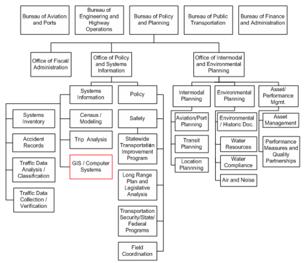
The GIS Section, which currently has a current staff of 5 full-time employees, maintains the Department's core enterprise GIS and associated geospatial data, prepares a wide variety of high-end cartographic products, and provides GIS services and support to both the Bureau of Policy and Planning, the Department, the State's Regional Planning Agencies and Municipalities as a whole. In addition, the GIS Section provides leadership and staff support for the Department's Geospatial Standing Committee. The Committee, made up of representatives from each of the Department's Bureaus, oversees the Department's geospatial information and activities and develops plans and strategies to implement the creation of the enterprise-wide GIS system solution. The recommendations made by the Geospatial Standing Committee are given to the Department's Strategic Information /Communications Systems Committee, for final approval.
With the Department's GIS user base growing to over 85 ArcView users spread throughout the main office, in the Planning, Engineering, Public Transportation, and Aviation and Ports sections, and with a core GIS staff of only 5, the GIS Development Section has recently established monthly GIS user workshops to provide staff with basic and advanced GIS application training so that they have the knowledge to perform GIS analysis to support their project needs.
Data Collection and Sharing
ConnDOT uses many different geospatial data sets originating from sources throughout the state and from within the Department. Internally, ConnDOT's Systems Inventory Section produces highway system inventory data associated with State and local public roadways. The data is currently available internally to all DOT staff with GIS software. With the implementation of ConnDOT's planned Oracle Spatial enterprise database the data will be more centralized and readily available to anyone requiring spatial data. In addition to the data developed internally, ConnDOT uses geospatial data produced by other state agencies, such as the Department of Environmental Protection and the Department of Public Health, which both make their data available for download from the Internet.
Data sharing efforts between state agencies are complemented by a statewide effort to consolidate, standardize, and enhance geospatial data. In June 2005, the State legislature established the Connecticut Geospatial Information Systems Council (CGSIC)16, which is made up of 21 members from various state agencies, to coordinate a uniform GIS capacity for municipalities, regional planning agencies, the state, and others. One of CGSIC's Strategic Goals is developing a core set of data layers that are kept up-to-date and made broadly accessible across all levels of government. The CGSIC's Data Inventory & Assessment Working Group is tasked with identifying framework datasets for the state, and establish polices, standards and general procedures for the submission, maintenance and dissemination of all geospatial data. The Working Group identified 12 framework datasets17 to be included in a State Spatial Data Infrastructure (SSDI), of which 4 priority layers, orthophotos, parcels, street centerlines, and address points, will receive the Council's initial focus.
Funding
Funding for ConnDOT's GIS activities comes primarily from Federal State Planning and Research (SPR) funds and through the National Highway Traffic Safety Administration (NHTSA) Highway Safety grants.
Key Success Factors and Recommendations
- Work to ensure data content accuracy and standardization - While ConnDOT has a large amount of data, it currently resides in various formats, degrees of accuracy and scale. As a result, the majority of the GIS Section's efforts and resources have gone towards re-formatting and re-standardizing data to make the datasets compatible with ConnDOT's GIS software. The Department is currently involved in the effort to develop statewide standards to ensure that geospatial data is useable by many different groups.
- Build support for GIS at the Management Level - Obtaining managerial support is critical to secure the funding and staffing levels required to accurately develop and utilize a robust GIS program. Securing this support often requires someone to champion the capabilities and benefits of GIS.
- Integrate Planning for GIS with other Information Technology Plans - ConnDOT's GIS and engineering application efforts are based in two separate Bureaus. By treating each technology separately, the direction and growth of the two programs are based on their respective Bureau's needs as opposed to Department-wide needs. Integrating planning for the two technologies under the purview of the IT Division would allow for one program to support Department-wide needs in unison.
Florida DOT Case Study
Contacts: Jared Casseaux
Jared.Causseaux@dot.state.fl.us
Larry Barfield
Larry.Barfield@dot.state.fl.us
Buddy Cunill
Buddy.Cunill@dot.state.fl.us
Peter McGilvray
Peter.McGilvray@dot.state.fl.us
Background
The management of GIS within the Department has shifted over the years. The Office of
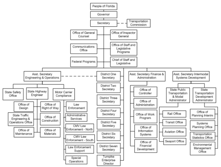
Information Systems (OIS) oversaw the development of all GIS applications (central office and districts) for many years. Close coordination with OIS was required for the use and application of GIS. Florida Department of Transportation (FDOT) is recognized by its peer agencies as a forerunner in the GIS arena. Forward thinking efforts within the agency are currently being led by a GIS Coordinator and Steering committees.
Business Model for Geospatial Technology Implementation
Organizational Structures
Approximately two years ago, the Department recognized that enterprise GIS issues would be best handled within a separate office reporting directly to an Assistant Secretary. This move ensures higher-level commitment to GIS within the Department.
Currently, the GIS Coordinator and Steering committees lead efforts within the agency to develop and grow the GIS program. The first meeting of the GIS Management Steering Committee was held in mid-2005 when the group established a vision and goals for GIS in the Department and a mission for the Steering Committee to promote and ensure consistent and efficient use of GIS. The committee is comprised of senior-level managers representing all business units and geographic districts in the State. In addition to goals related to communication and coordination, the committee's task is to define criteria and requirements for workgroup, enterprise, and external GIS applications. A Functional Steering Committee works under the Management committee by formulating recommendations related to GIS. The Functional committee is comprised of central office as well as District GIS coordinators.
Figure 6. Organization Chart for the Florida Department of Transportation
Applications
The following describes some of the FDOT applications that traverse multiple systems or districts, or serve several functional areas and therefore are considered enterprise applications:
- Efficient Transportation Decision-Making (ETDM/EST) - When Congress passed TEA-21, the Central Environmental Management Office of the FDOT decided to reexamine the Department's entire process from the very early stages of planning through project development and permitting. Revamping the entire process required that a more efficient methodology be used to present project planning information and to gather input from agencies and the affected community. As part of the new Efficient Transportation Decision-Making (ETDM) process, the FDOT implemented an Internet-accessible interactive database tool called the Environmental Screening Tool (EST). The EST provides tools to input and update information about transportation projects, perform standardized analyses, gather and report comments, and help synthesize and communicate that information.
- Enterprise Strategic Intermodal System (ESIS) - The ESIS project was established in July of 2005 to integrate and automate transportation and modal project planning processes established during the implementation of the SIS. An ESIS Management Steering Committee (MSC) and Functional Steering Committee (FSC) were established with representatives from each of the Intermodal System Development (ISD) offices directly involved in the SIS initiative, including:
- Environmental Management Office (EMO);
- Office of Policy Planning (OPP);
- Public Transportation Offices (PTO);
- Systems Planning Office (SPO); and
- Transportation Statistics Office (TSO).
- Roadway Characteristics Inventory (RCI) - RCI is a database of various physical and administrative data, such as Federal functional classification, pavement, shoulder, and median data related to the roadway facilities that are either maintained by, or are of special interest to, the FDOT.
- Enterprise View - Available via FDOT's Enterprise Information Portal (EIP), GIS Enterprise View provides an interface with basic GIS viewing functionality. It is the main GIS viewer used by Central Office for graphically displaying basemap layers, as well as some information in other Central Office databases, including RCI. It also ties with the Video Log.
- Florida Unified Basemap - For agencies to effectively communicate information with regard to roadway business data, the Florida Safety Office initiated a project to evaluate the feasibility of a comprehensive roadway network, which could be internet-accessible, and managed and maintained through documented procedures, standards, partnerships, and cooperative agreements. The feasibility study completed early in 2007 indicated a need for a comprehensive roadway network. Currently, an implementation plan is being developed for this initiative.
- Transportation Automated Information Management System (TAIMS) - TAIMS is a web-based system originally developed by the Planning Office in District 5, but is currently under Production Management. The system consists of 10 modules, including Transportation Modeling; Level of Service; Design Traffic; Environmental; Public Transportation; Work Program; RCI; and Growth Management, to name a few. Each module has a consistent interface that, depending on the module, may include data entry forms, query screens, reports, and interactive maps. Tools available include the ability to produce mailing labels from buffered corridors. TAIMS includes over 80 GIS layers. RCI and Work Program data are automatically downloaded on a daily basis from the Central Office servers. Other data layers include level of service (LOS), adopted models, access management, Developments of Regional Impact (DRI), and many others.
- Turnpike Enterprise Asset Management System (TEAMS) - TEAMS is a comprehensive management tool for Turnpike assets and related information. It contains an inventory of the Turnpike's fixed assets, including condition assessment and replacement costs. The system also calculates predicted time for renewal and replacement, and provides support for budget development. Asset-related modules in TEAMS include facilities, roadway, structures, NPDES, pavement, and work program. TEAMS is also integrated with several of FDOT's systems, including Work Program, RCI, DataStream Work Order System, and PONTIS®, and dynamically maps milepost-based data on the fly, including RCI, pavement, and crash data, among many others. Reports and maps are inter-related allowing the users to go from an asset report to a map showing its location and vice versa. It also includes links to MicroStation files, inspection reports, and other documents, as well as a video log.
- Turnpike Management Information System (TMIS) - TMIS is a web-based GIS system that serves several types of GIS data layers, including aerials, via an ArcIMS web interface. Data is stored in an ArcSDE system running on SQL Server. All GIS data has metadata that meets Federal Geospatial Data Committee (FGDC) standards. The spatial database administration has a timetable for data maintenance with most datasets updated annually.
Data Collection
The majority of data, including aerial photos and roadway networks, are collected in-house and by each of FDOT's districts, but some external sources (e.g., government agencies, external parties) provide other geospatial information. FDOT hopes to develop an enterprise system that will complement, rather than replace, collection methods, instead leveraging off of existing processes.
Funding
FDOT GIS applications are funded through a number of sources depending on the application, functions, players, and requirements. A small, office-level GIS maybe funded locally, while other available resources may fund a larger office or cross-functional GIS application(s). Examples of other available resources include the use of district level funds, research dollars, State Planning and Research (SPR) dollars, federal grants, or consultant budget.
Future Trends/Plans
FDOT's future plans include:
- Creating department-wide standards to support a move from decentralized GIS applications to a centralized GIS repository, and
- Creating performance measures to better understand how geospatial applications function and add value to the FDOT business processes.
- Formulating pilots and developing implementation plan that detail steps for successful implementation of enterprise GIS - (phase 2 pending approval from business case).
- Implementing enterprise GIS along with documented procedures and policies - (phase 3 pending approval from pilots).
Challenges
- Budget considerations - In addition to the inherent expense of GIS development, state-level budget cuts have made it difficult for FDOT to fund the GIS program.
- Budget Cycle - A common challenge in government is how to make justifiable programming and execution choices for future budget cycles when the technology changes rapidly.
- Turnover - Decreasing staff and loss of expertise.
Key Success Factors and Recommendations
- Take small steps - When it comes to setting goals for enterprise GIS development, a general consensus is to tread in small steps. Taking small steps helps in summarizing success and failure at each stage, and the ability to learn lessons before moving too far down the road. In addition, this process helps attract support and user divisions that seek to streamline cost-effective business processes with the rest of the organization.18
- 'Vertical' and 'horizontal' support - Key factors in building FDOT's GIS program were high-level (vertical) as well as implementation (horizontal) support from users. These factors, moreover, are universally important to all state DOTs, regardless of organizational culture. If a goal of developing enterprise GIS is presented to the upper levels of management, any pitfalls in its development and implementation would potentially result in loss of confidence and support in the program. It is important to identify champions and supporters who are enthusiastic about the contributions of enterprise GIS to the business needs of user divisions and the organization as a whole.
- Coordination facilitates enterprise GIS - Having GIS point persons in each division, as well as better coordination with user divisions, will help avoid any perception that enterprise GIS is a data take-over program by the GIS group. GIS point people in the user divisions can effectively relay the utility of geospatial applications for business needs. Having this support system in place will help avoid alienating user divisions. A successful enterprise GIS system should obtain a clear understanding of the system from the user and business process perspective and be able to balance interests of all involved parties.
- Ensure a common perception of enterprise GIS - Perceptions about the utility of enterprise GIS - not to mention the very concept of 'enterprise GIS' itself - means different things in different state DOTs, depending on the business requirements, the extent of data integration, and the needs of user divisions. Perceptions about what enterprise GIS can offer often revolve around expectations that are different from immediate business goals.
- Track time and cost savings - Appropriately tracking time and costs savings realized by utilization of GIS will help to showcase and quantify achievements of the technology. Cost-benefit analyses might not be considered feasible in some state DOTs due to procedural issues in recording time, but any cost-benefit analysis can be an assertive tool to demonstrate the success of implementing an enterprise GIS. Also, it is important to consider the value of having a quantitative understanding of benefits, rather than relying on an intuitive or anecdotal understanding of benefits.
Hawaii DOT Case Study
Contact: Goro Sulijoadikusumo, (808) 587-1839
Goro.Sulijoadikusumo@hawaii.gov
Background
The Intermodal Surface Transportation Efficiency Act of 1991 (ISTEA), which originally required all states to establish a number of management and monitoring systems codified under 23 CFR 500, provided the impetus for the Hawaii Department of Transportation (HDOT) in 1996 to undertake the development of a roadway information system (RIS) architecture conforming with results of the 1995 FHWA pooled-fund study entitled GIS-T/ISTEA Management Systems, Phase A - System Architecture. Any of the management systems can now be integrated with this operational roadway information system (RIS) based on this architecture. The traffic monitoring system, the Highway Performance Monitoring System (HPMS), which is required to satisfy 23 CFR 1.5, and the Highways GIS web portal are all already integrated into the RIS.
Business Model for Geospatial Technology Implementation
Organizational Structure
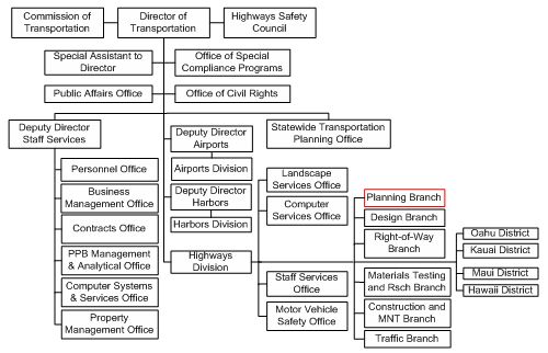
HDOT's GIS activities are not coordinated department-wide, nor are there any dedicated GIS technicians. Instead, specific offices and individuals perform GIS analysis in addition to their existing job responsibilities. In the Highways Division, this responsibility falls in the Planning Survey Section under the Planning Survey Engineer, who is responsible for many of the information and statistical programs of the organization such as HPMS, road inventory, and traffic monitoring. This position is located in the Highway's Planning Branch (see Figure 7), where much of the Department's geospatial information is utilized.
Figure 7. Organization Chart for the Hawaii Department of Transportation
Data Development and Sharing
HDOT develops the majority of its highways geospatial data internally through its Highways Planning Branch. All data are centralized in the Oracle spatial relational database management system (RDBMS)-based RIS, which staff can access through the Highways GIS Web Portal as well as any other ODBC compliant software. The Portal, which is accessible to all internal staff, provides a dynamic map interface that provides easy access to the data to all internal DOT staff. The Web Portal allows users to view any area in the state and access information such as traffic, road inventory details, bridges, pavement, and project information, all of which are linearly referenced using a system of routes and mileposts. HDOT also maintains an extensive digital photolog; photographs are taken every .002 miles or 10.56 feet on every state and county roadway (functionally classified as a collector or above) on every lane (basically 500 images per mile for each camera with a minimum of two cameras). These images are also available to internal staff via the Web Portal and also through specialized software that allows for measurements and database creation. HDOT has been contracting out its photolog collection and data processing for the past 5 years, but continues to perform its own quality assurance/quality control and final data publication.
HDOT also shares and receives data from both state and federal government agencies, specifically the Army Corps of Engineers. However, a recurring issue for HDOT in sharing data with non-transportation agencies is an inconsistency in data standards concerning exchanging information on roadway infrastructure and characteristics. HDOT currently follows the data standards outlined in NCHRP 20-27(2), A Generic Data Model for Linear Referencing Systems,19 which fit the transportation agencies' needs, but do not support agencies that rely on Land Information Systems (LIS) geospatial data for analysis. As such, when sharing data with state agencies, HDOT does not typically share the raw data, but instead will create shapefiles of the requested data.
Funding
HDOT's GIS activities are funded through federal State Planning and Research (SPR) Part I funds. Although HDOT does not generally couch its GIS in terms of a 'cost-benefit' analysis, it acknowledges that the availability of photographs and roadway information has greatly facilitated decision-making, particularly the ability to complete temporal analyses of facilities performance over time. Prior to the availability of photographs and roadway information, it was often necessary for DOT staff to fly repeatedly to Hawaii's various islands to conduct preliminary engineering and design. Now, with the web-based photologs, staff members can view images from their desks to answer many of the preliminary questions.
Challenges
One of the greatest organizational challenges in expanding the use of GIS to improve decision-making has been organizational resistance to technological change. Many offices and staff members are reluctant to utilize GIS because they do not fully understand the benefits that information technology can bring to their work processes, and are still more comfortable operating in a paper and pencil environment. Since the knowledge and expertise required to effectively utilize GIS is not part of a civil engineer's traditional training and experience, the Planning Survey Engineer tries to provide on a quarterly basis, training for its staff on available GIS resources and applications. However, due to lack of support from some offices, there has been limited success in getting the organization to accept GIS as a new business tool to support transportation decision-making.
Key Success Factors and Recommendations
- Look towards states with successful programs - As HDOT sought to develop its data repository, it looked to other state DOTs with similar operations that had GIS programs in place. Instead of reinventing the wheel, HDOT built upon successful GIS applications already being used by the Tennessee and Oregon DOTs. HDOT defined a 'successful' GIS application as one that provided technological benefit and the ability to improve internal communication.
- Adopt open, non-proprietary data standards - IT is becoming an increasingly important aspect of transportation activities. As such, DOTs require data and communication infrastructures that a range of stakeholders can share. In order for geospatial information and services to be accessible and useful to a wide range of users, DOTs should utilize an open, flexible and vendor-neutral data framework, such as XML standards and those promoted by the Open Geospatial Consortium, Inc. (OGC).20
Idaho Department of Transportation
Contact: Glenda Fuller
Glenda.fuller@itd.idaho.gov
Background
How Idaho Transportation Department's (ITD) GIS activities have been organized and implemented has changed over time. Beginning in the late 1990s, the GIS program at ITD has had a dynamic history, first moving from a centralized to a more decentralized model and then, recently, beginning the steps to return to a centralized model. ITD anticipates that a centralized model will provide needed infrastructure to its GIS program.
Business Model for Geospatial Technology Implementation
Organizational Structure
Originally, ITD's GIS activities were housed in the Cartography Unit in the Division of Transportation Planning. As GIS software became more ubiquitous and visible at the Department, support from upper management to grow the GIS program emerged. Over time, the desire to further develop GIS led ITD decision-makers to the conclusion that a decentralized model might encourage continued and more widespread adoption of the technology. In 2005, the centralized model for GIS at ITD was dissolved in favor of distribution throughout the Department's six districts.
It became apparent, however, that decentralization was ultimately weakening the program. By separating users from one another and removing the 'communal' basis of GIS, there was no central body to manage and coordinate a unified business mission. Recently, ITD completed and has started to implement a department-wide Strategic Action Plan that focuses on rebuilding a centralized GIS infrastructure.
ITD's GIS Unit is currently located in the Transportation Planning Division. The unit's major functions are:
- Digitizing data
- Creating maps
- Formulating data-collection standards, and
- Providing technical expertise for outsourced work.
Currently, the unit employs one full-time employee, but is working to increase its staff to approximately eight. When making new hires for the GIS Unit, ITD generally seeks individuals with an IT background and experience in programming, model-building, and/or database administration.
Data and Data Accessibility
ITD acquires data from a variety of sources. Because nearly 70 percent of the state is federal land, the Bureau of Land Management (BLM) and U.S. Forest Service (USFS) are important sources of geospatial information. However, obtaining data from these sources is not always easy. For example, some entities require data users (including ITD) to sign different agreements for each data layer requested. ITD has expressed concern that such policies can hinder the efficient exchange of data between federal agencies and all GIS users. One potential solution is for the State to sign one collective agreement for these data. In addition, ITD obtains data from other external sources such as utility companies and Idaho's five tribal governments, three of which maintain sophisticated GIS with extensive data on reservation roads, and archeological and cultural resources, among other features. There is an ongoing need to set and implement standardized data-sharing policies with these entities.
In the absence of firm standardization policies, ITD has found it challenging to build a core data infrastructure. In addition, the state's rural setting and relatively low population density (over 1/3 of counties have a population density of under six people per square mile, as compared to the U.S. average of 83 people per square mile21) has made it difficult to collect a broad range of high-quality data. The Strategic Plan addresses how data layers can be better created and maintained, as well as how standardized metadata library filing can help market the program to new GIS users.
ITD purchases pooled licenses, which allow users to access database information via desktop applications. Currently, users have limited online access to maps, but internal users can access data via a map and image library. Some external users (e.g., ITD consultants) can access the library using a VPN client. However, there has been no standard filing convention set for the library, which makes it difficult for users to access metadata that may not be online.22 This mode of access may change in the future as the Department works to remove applications from users' desktops and make data and maps accessible and interactive via inter- and intranet applications.
Applications
As part of its Highway Data Quest application23, ITD maintains 27 transportation features, which include information on assets such as ports of entry, highway rest areas, and roadway centerlines. To enhance these layers, ITD establishes data needs according to what the business need priorities are at the time. With business needs identified, the GIS Unit works to collect or create the corresponding geospatial data potentially meeting the business needs.
ITD offers several static applications, including a milepost log, and has a robust set of county and local highway district maps that date to 1930. The 'Local Road Systems Map search' functionality24 on the ITD website allows users to search roadway maps by county and year. Local jurisdictions set their own standards for collecting and maintaining data, and counties annually submit data to ITD for review.
Funding
FHWA's SPR funding supports ITD's GIS program. The estimated annual budget is nearly $1M, which covers personnel and operational costs. Decisions regarding budget requests are made by an executive team and upper-level managers. ITD has not completed a formal cost-benefit analysis in terms of the return on investment in GIS, but instead generally frames the benefits of GIS in terms of how the technology can support the business needs and strategic goals of the agency.
Challenges
ITD has encountered several challenges in advancing its GIS program. Some of these challenges include:
- Cultural shift due to centralization - Having operated under different business models, ITD's GIS Unit has found that centralization changes roles, responsibilities, and tasks within the Department. ITD recommends that state DOTs seeking to make changes to their own GIS business models be particularly aware of how such change may influence internal dynamics.
- Lack of strategic plan early on - ITD's GIS program grew organically; historically, there was no strategic plan to guide the program. Without a strategic plan in place, ITD sometimes found it difficult maintain a stable GIS operating environment and effectively respond to user requests. To address these issues, ITD's recently completed Strategic Plan will rebuild a centralized GIS architecture and formalize the program's business missions.
Future Activities
In the future, ITD anticipates developing a "timeline of responsibilities" that sets tasks and milestones for the Department's return to a centralized GIS program. The timeline's period of performance is 3-6 months, thus allowing ITD to quickly assess the degree to which tasks are being accomplished. Having this relatively short time horizon helps to ensure that the GIS Unit can continue to demonstrate the benefits of its decision to become centralized again.
ITD also plans to continue the enhancement of its data layers, particularly those for ROW, intersections, and curb cuts, as well as the establishment of specific definitions for data features in order to limit redundancies and inconsistencies.
Lessons Learned
- Encourage collaborative organizational culture - As is the case for many state DOTs, ITD does not always have the resources to create, obtain, and/or conflate datasets for the state. However, an organizational culture that encourages staff collaboration, careful consideration of the range of internal skill sets, partnership opportunities between DOT agencies, and events such as peer exchanges, can contribute to removal of internal and external silos that may be preventing data sharing.
- Maintain a regional perspective - ITD emphasizes the importance and benefits of having a regional perspective on geospatial data. Instead of focusing on only state highways or roads, ITD uses GIS to present geospatial "snap-shots" of travel corridors that may cross the state's boundaries. Using this regional model, ITD can, for example, recommend efficient traveling routes in cases of weather-related emergencies, even when these routes extend over state lines. FHWA could contribute to states' efforts to mature a regional perspective by continuing to support meetings where neighboring states or states sharing common transportation needs based on physical geography or other factors can share their experiences.
Indiana DOT Case Study
Contact: Joel Bump, 317-234-3106
jbump@indot.in.gov
Background
The first GIS activities at Indiana DOT (INDOT) began in the late 1980s with GDS. Originally carried out in the Design Division to replace mylar design plans and as-builts with digital as-built plans. The technology migrated to the Graphics Engineering division in the 1990s to include digitizing the "mylar and ink" based road inventory. By 2000 migrations to MicroStation for CAD and ESRI for GIS were underway. After observing the experiences of early GIS-adopting state DOTs, GIS advocates at INDOT made a bottom-up push for GIS' widespread adoption within the agency, often communicating to decision makers how GIS could benefit various business needs. Now, INDOT is no longer in a data building mode for its GIS but instead is focusing on data maintenance, systems integration, and support for its estimated 400 end users in the desktop environment and thousands of end users of INDOT's web based GIS products.
Business Model for Geospatial Technology Implementation
After the 2004 gubernatorial election in Indiana, and the lease of INDOT's toll road to fully fund its next 10 years of construction and maintenance plans, INDOT decided to reorganize the entire agency. With this new influx in projects and increasingly tight deadlines, INDOT made a commitment to build future projects as efficiently as possible - a goal INDOT believed would be facilitated by modifying how it was organized. One result of the restructuring, which was completed in 2006, was to organize INDOT's GIS support staff under the IT Division called Business Information and Technology Systems (BITS). This division is responsible for establishing the GIS policy for the Department (see Figure 8).
Figure 8. Indiana Department of Transportation Organization Chart with GIS User and Data Maintenance Distribution
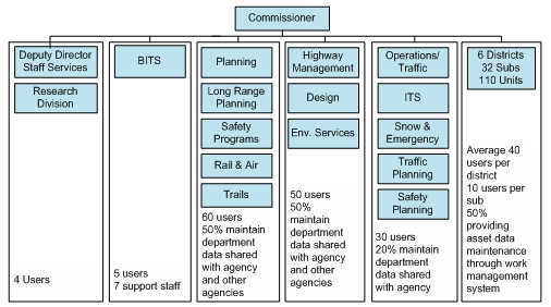
Currently, the seven full-time GIS staff in the IT Division consist of a coordinator, a database administrator, three application developer/managers, and two GIS analyst for cartographic and analysis projects. This staff's work is supplemented and supported by approximately a dozen employees from the Planning Division who are responsible for digitizing and maintaining the road inventory data. When considering the hiring of new GIS staff, the IT Division often seeks people from a mixture of backgrounds. Depending on current project needs, both software development and GIS/cartography skills are valued. Background in transportation, engineering, CAD or planning are also desired.
INDOT's GIS customers are distributed throughout the agency, with the predominant users being staff in the Planning Division, the Office of Environmental Services, Traffic Engineering, and the Operations Support Division - the division responsible for asset management and maintenance, among other duties. How customers request GIS support depends on the scope of the project. Basic questions are handled through an online helpdesk application at two tiers. The first tier of basic administration or Q&A gets complete responses within the hour. The second tier support for data issues, map requests, remote support, software installations and one-on-one assistance receives full support in less than 16 hours response time. Before decisions are made for large scale projects, such as developing datasets or new applications, staff from the IT Division will meet with other Divisions' staffs to discuss project scope, budget requirements and personnel implications of various levels of GIS support. Based on the outcomes of these meetings, a determination is made on the geospatial projects that can be performed in-house versus those to be out-sourced.
Data Accessibility and Delivery
INDOT has acquired a floating license for its desktop GIS software (ArcGIS 9.2). Anyone within INDOT's headquarters and/or its six districts who has the software (and sufficient hardware) can access and use the Department's geospatial data. These data consist of data developed in-house, data purchased through contract work, and data made available through one of several sharing arrangements with counterpart state agencies and/or statewide governmental GIS outlets, such as the Indiana Geographic Information Council (IGIC)25 and the Indiana GIS Center of Excellence (GIS CoE). The GIS CoE was created through an MOU by state agencies in Indiana to jointly leverage their individual talents, funding and resources to deliver greater GIS services to the state agencies of Indiana at the same or lower operating cost than running as individual agencies departments.
INDOT makes much of its geospatial data available to the general public via the Indiana GIS Atlas,26 a web-based atlas which allows users to construct custom maps from a variety of data layers, including demographics, infrastructure and environment. INDOT funded the development of the Atlas, which is now maintained and hosted by the Indiana Geological Survey. In the future IndianaMap will become the one stop portal for access to all publicly available data from Indiana state and local resources.
Funding
The IT Division's GIS work is funded from INDOT's IT budget; the budget for GIS is approximately $100,000 - $150,000 per year. SPR funding from FHWA supports the digitizing and inventorying work of INDOT's Planning Division as well as other division's planning and research projects that use GIS. Previously the IT Division absorbed Divisions' new GIS hardware or additional license costs, but now each division is responsible for funding its own IT needs, which are then supported through BITS. Therefore, business area requirements dictate from where funding will come and how much it will be.
In addition, other less ordinary funding models are being explored within Indiana state government. For example, in 2005 the Indiana Geographic Information Council (IGIC) coordinated the 2005 Statewide Digital Orthophotography Program, which facilitated the acquisition of statewide, high-resolution orthophotography and digital elevation data for Indiana. A unique arrangement between the state USGS and Homeland Security was able to pay for the base layer while counties had the option to buy higher resolution for their county. Further statewide coordination was needed to fund a solution to efficiently manage and deliver the new orghophotography. INDOT purchased a new server to house the state's orthophotos, the Indiana Department of Natural Resources funds the server's operating costs, the Indiana Department of Environmental Management funds for the software costs, and a number of additional stakeholders (e.g. USGS and the Department of Homeland Security) contributed funding for other aspects of the project. This effort would have otherwise been too costly for one agency to build alone. Given the success of this agreement, INDOT anticipates these and other counterpart agencies' joint consideration of statewide enterprise licensing options and other GIS server sharing arrangements in the future.
Challenges
Some common obstacles and challenges that INDOT has faced include:
- Lack of funding - GIS customers sometimes request geospatial outputs or products that are beyond the scope of current budget levels. This can force the postponement of work.
- Inconsistency in how local governments share local geospatial data - Many state agencies in Indiana are trying to work with local governments to acquire geospatial data - especially a parcel layer. Of Indiana's 92 counties, 70+ have a GIS of some sort. Some of the counties share their data freely while others want to charge fees, which Indiana legislation allows. Counties that have contracted out the development of their GIS to 3rd party vendors will occasionally want to recoup cost of the data.
Key Success Factors and Recommendations
- Avoid intra- and inter-agency work silos - Establish good working relationships with both internal and external counterparts. Once working relationship are formed the sharing of data and resources between agencies flows more easily. Furthermore, cooperating groups can more effectively solve problems that are likely experienced by all.
- Overcome agency 'silos' - Indiana's 2005 Statewide Digital Orthophotography Program is an example of agencies working to overcome agency and jurisdictional silos. Once the orthophotography was acquired, INDOT shared their vector road data with IGIC. Other agencies shared as well and IGIC was able to distribute the orthos, vector data and data viewers to online users as well as public libraries and schools throughout the state.
Iowa DOT Case Study
Contact: Eric Abrams, (515) 239-1949
eric.abrams@dot.iowa.gov
Background
The Iowa DOT (IDOT) began to use GIS in the late 1980s, with the creation of digital county and city maps and roadway inventory records stored in an Oracle database in a CLIX system. In 1990, IDOT conducted a GIS demonstration project, funded by the US Department of Energy, to study a proposed realignment of US 151. The project combined data from IDOT and the Department of Natural Resources to determine the optimal alignment. Encouraged by the results of the demonstration project, IDOT's Planning and Highway Divisions investigated additional GIS applications. Subsequently, in the mid-1990s, IDOT's first GIS Coordinator position was created within the Planning Division. Over time the Department-wide GIS needs expanded, and the GIS Coordinator position was moved within the Information Technology Division to better support the Department as a whole.
Business Model for Geospatial Technology Implementation
Organizational Structure
Implementation of GIS activities is dispersed throughout the Iowa DOT. The Spatial and GIS Coordination Group within the Information Technology Division (see Figure 9) coordinates GIS and spatial technologies for the Department and assists offices that want to use GIS by helping them procure the proper technologies and technical resources to meet their GIS needs. The GIS Coordination Group consists of 3.5 full time staff, of which 2 perform IT functions, one is a programmer/analyst and another is responsible for imagery and GIS training needs.
Figure 9. Iowa Department of Transportation Organization Chart - July 2007
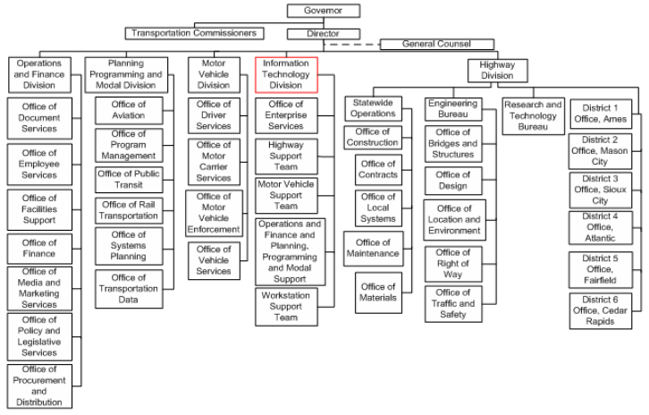
Each IDOT Office that uses GIS, namely the Office of Aviation, Office of Traffic and Safety, Office of Location and Environment, Office of Transportation Data and the Office of Program Management, is responsible for a GIS business analyst who supports that office's day-to-day GIS analysis and report and map creation. In addition to a GIS analyst, each Division also has their own IT support staff, whose geospatial activities are coordinated and/or advised by the Department's GIS Coordinator.
Data Development
Iowa DOT develops a large amount of GIS data in house. The Transportation Data Office, the Department's largest data producer with a staff of 30, collects data on all public roadways, structures and rail-crossings. The Transportation Data Office has been maintaining road data for all public roads, including those outside of IDOT's responsibility, for the past 50 years, and now relies on aerial photography to update this dataset. IDOT also relies on input from county and city public works departments to update the statewide road inventory. In the future, IDOT is looking to create a web tool that will enable counties to directly enter information on surface transportation projects and it will be uploaded into the DOT road inventory database.
Data Sharing
The Department shares its geospatial data internally via a central database. All spatial data that will be used across the DOT enterprise resides in Oracle Spatial; however, many DOT offices have spatial data that is only used within its office, and such data typically resides in formats other than Oracle Spatial (shape, access, excel, text, etc). IDOT also shares its raw data with other agencies and the public via the DOT website; however GIS software is required to use the spatial data. IDOT does provide a subset of spatial data in a format compatibility with Google Earth, which enables individuals without GIS software to utilize the data.
In addition to the data created internally, IDOT receives data through partnerships with other state agencies and counties. IDOT is currently cooperating with several other state agencies on a Statewide LiDAR project. Iowa is one of the first states in the country collecting a state-wide Light Detection and Ranging (LiDAR) dataset. LiDAR data is extremely useful in to many agencies for environmental, transportation and planning applications, but the data can be prohibitively costly for a state agency to develop individually. As such, IDOT, the Department of Agriculture and Land Stewardship, the State Office of USDA NRCS and the Department of Natural Resources, are cooperating to share the costs of this $4 million project. Once the LiDAR raw data is developed, it will be free and available to the public.
An additional statewide GIS collaboration effort is the Iowa Geographic Information Council (IGIC),27 whose mission is to foster an efficient GIS environment through cooperation and coordination with public and private entities. To improve data coordination the IGIC is developing a statewide spatial data infrastructure, known as the Iowa Geospatial Infrastructure (IGI), which will include seven framework data layers and will be accessible to all levels of government and the public.
Funding
Just as the implementation of GIS activities is decentralized, so is the funding for these activities. Formerly, the Spatial and GIS Coordination Group funded all GIS software purchases, but as offices began expanding their usage of GIS, the responsibility for purchasing the licenses was transferred to the users. Each DOT office purchases their GIS software and licenses for use by all Iowa DOT GIS staff and funds their GIS work, while the GIS Coordination Group maintains the data storage, technical infrastructure and software maintenance costs.
Key Success Factors and Recommendations
- Qualified Staff are a Critical Component to a Successful GIS Program - While Iowa DOT has a great deal of geospatial data it lacks staff with the skills to utilize the data. The knowledge and expertise required to analyze geospatial data is not part of the traditional DOT staff training and experience. Providing significant training to current staff or hiring staff with geospatial analysis skills is necessary to effectively utilize IDOT's GIS resources.
- Standardize GIS Platform - Iowa DOT uses a central Oracle Spatial database to store enterprise data, but it uses the spatial data in a number of different platforms including the web, GIS software, and report software. Coherently integrating the various GIS applications into one platform that performs a number of functions would help to improve services and productivity.
- Develop Support for GIS at the Management Level - Support for GIS at the Office Director level has been integral in implementing IDOT's GIS activities. Securing management's support enables offices to receive the funding necessary to carry out GIS activities.
Kansas DOT Case Study
Contacts: Nancy Mattson
NancyM@ksdot.org
Bill Vicory
BillV@ksdot.org
Brian Logan
Brian@ksdot.org
Mike Smith
MikeSm@ksdot.org
Background
Kansas DOT's (KDOT) GIS activities began in the mid-1980s, a period during which KDOT began converting data used in the Department's CAD systems into an initial GIS. After chartering the first GIS-T Symposium in 1987, staff within KDOT's Cartography Unit, which was located in the Division of Planning and Development, began championing the use of GIS, spurring its integration into the KDOT workplace. Now, KDOT - an agency responsible for managing more than 10,000 miles of state and federal highways - has developed several web-based GIS applications through which geospatial information is available to all staff; it is estimated that there are approximately 100 GIS customers within KDOT. As GIS technologies continue to become more and more automated, KDOT expects to create an enterprise GIS that will have components that are web-accessible to external users.
Business Model for Geospatial Technology Implementation
Organizational Structure
In efforts to spread geospatial enablement skills within KDOT, it was decided several years ago to dissolve KDOT's "GIS Unit." Since then, GIS activities at KDOT have been primarily carried out in the Bureau of Transportation Planning, which is part of the Division of Planning and Development (see Figure 10).
Figure 10. Organization Chart for the Kansas Department of Transportation's Bureau of Transportation Planning
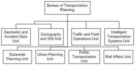
Currently KDOT has eight staff members within the Cartography and GIS Unit dedicated full-time for GIS application development, while several staff in other areas of KDOT (including the Division of Planning and Development, which maintains the Department's base geometry data) carry out supporting GIS functions. When hiring new staff, KDOT typically seeks individuals with a strong understanding of database development and administration, as well as an aptitude to grasp geospatial applications.
Some of the primary responsibilities of those in the Cartography and GIS Unit include:
- Making maps,
- Setting data standards for the Department, and
- Managing the geospatial components of projects that have been outsourced
- Outreach and education
Geospatial Data Acquisition
KDOT acquires data from a number of sources, most of which are internal to the Department, which has traditionally focused on state and federal highways (state system). As a part of their day-to-day business functions, surveyors support an ongoing effort to collect geospatial data, which is eventually incorporated in the GIS. KDOT also maintains a partnership with a local university to create and/or maintain street centerlines and other feature data, such as bridges.
Sources of data are expanding outside KDOT and imagery is obtained whenever possible. KDOT has partnered to obtain statewide orthoimagery data for the years 1991, 2002, 2003, 2004, 2005, and 2006. KDOT hopes to be part of a funding partnership to obtain 2008 orthoimagery data.
Recognizing a need for increased standardization at the state level to align these data collection efforts, among other issues, the Governor of Kansas created the Kansas Collaborative. As part of the Collaborative, a GIS Breakthrough Team28 was established with the objective of better linking GIS implementation efforts at the state and local levels.29 As part of its work, the team conducted outreach and education sessions with GIS customers at the county level to determine what geospatial data are currently available. Now, the team is collaborating with KDOT to identify areas where geospatial data are lacking and also where funding/resources should be concentrated for future data development efforts.
Another statewide group working to maximize GIS investments is the Kansas GIS Policy Board, which was established in 1989. KDOT is one of 37 Governor-appointed member organizations participating. The board is responsible for the development of standards, strategies, and policies that emphasize cooperation and coordination by creating public and private partnerships throughout Kansas. The board also provides review, coordination and recommendations for GIS programs and investments.30 The GIS Policy Board also has several Technical Advisory Committees that concentrate on creating and maintaining statewide coverage of critical data layers, such as roads and bridges, hydrography, elevation, imagery, cadastral, and administrative boundaries, all of which are georeferenced to the same base.
KDOT works closely with the Data Access and Support Center, the GIS Clearinghouse for the State of Kansas,31 to develop standardized data management policies.
Major projects are currently underway to expand the orthoimagery currently available as well as updating elevation data. The Department also aims to digitize data on salvage yards, permanent signing, and is building footprint maps for historical imagery and railroad right-of-way strip maps. A major challenge in accomplishing these efforts is securing the funding necessary to support them.
Geospatial Data Accessibility and DeliveryKDOT makes its GIS data accessible via KGATE,32 the Department's internal GIS web portal. KGATE was designed to graphically display data that has been collected by different work units within and outside of KDOT. The system displays data held in different platforms as well as varied data types. Some geospatial data are also made available on KDOT's 511 road condition and detours real time map,33 a system designed to provide travelers in Kansas information about various road conditions (e.g. weather and detour information) that may affect travel decisions.
KDOT uses Intergraph's TerraShare for orthoimagery and other raster data management and distribution. Imagery and other raster data in the TerraShare environment can serve as backdrop layers for GIS applications, such as Intergraph's GeoMedia product suite, ESRI's ArcView or ArcGIS, and Bentley's MicroStation. TerraShare is installed on approximately 165 client desktops with more viewers using KGATE, KDOT's GIS web portal.
Funding
SPR funding from FHWA provides the salaries of KDOT's GIS staff, while the capital outlay budget supports the remainder of GIS-related costs. In addition, KDOT's Bureau of Computer Services provides some funding for software/hardware development, while the Department of Homeland Security sometimes provides funding for data collection at the local level.
To date, KDOT has not completed a cost-benefit estimate for its GIS activities, but the Department works to ensure that new data acquisitions and applications development complement - not duplicate - existing systems. The business case for investment in GIS at KDOT is generally not couched in "cost savings" terms, but in terms of how the Department's goals can be most efficiently accomplished.
KDOT's annual budget for GIS activities is currently approximately $1.5 M.
Challenges
Some challenges that KDOT has faced in implementing its GIS program include:
- Need for consistent planning/standardization - To some extent, KDOT depends on federal geospatial data sources such as the National Agriculture Imagery Program (NAIP) to acquire GIS imagery. This reliance, however, means that the quality of data in KDOT's databases can be compromised if the sources are outdated. KDOT has worked to build a plan to maintain data acquisition efforts even in times when primary data sources are unreliable, inconsistent, or unavailable. While KDOT has no major plans to dramatically change or expand its current GIS applications, it recognizes a need for a state-level mechanism to ensure the standardization of data-collection efforts.
- 'Growing the business' - Roughly five years ago, KDOT experienced rapid growth in its GIS program. More recently, the Department has found it challenging to sustain that level of growth. KDOT would like to expand its GIS work, especially regarding state-wide parcel information and allowing external use of the web portal, but has encountered some difficulty in obtaining the necessary funding and negotiating data-sharing policies, (e.g., regarding security and confidentiality issues).
Key Success Factors and Recommendations
- Have a reliable IT division to ensure a stable operating environment is maintained.
- Encourage agency-wide support and provide opportunities for staff members to learn from each other - In order to develop agency-wide trust in GIS utility, it is important to encourage and maintain support from top-level managers as well as all agency staff members. KDOT's Cartography Unit provided the initial impetus for developing a GIS at the Department, "paving the way" by sharing its interest and expertise in maps/geospatial visualization with others throughout KDOT. The Cartography Unit's encouragement subsequently led to the establishment of a high-level and widespread support of GIS. Currently, KDOT sponsors ongoing training programs in GeoMedia applications to help further learning.
- Work to integrate GIS data from a variety of sources to enhance a state's "full picture" - KDOT has worked with the State's archivist to integrate historical mapping information into a GIS. Although KDOT has encountered some challenges in this work, its goal of using GIS to enhance the state's cultural and historical archive is notable. It is important for states to consider a range of data sources for GIS as well as the ways in which geospatial technologies can enhance the "full picture" of a state.
Kentucky Transportation Cabinet Case Study
Contacts: Will Holmes, (502) 564-9900 x-3486
Will.Holmes@ky.gov
Background
The Kentucky Transportation Cabinet (KYTC) has invested in GIS since 1991, when dynamic segmentation technology was introduced, providing a linear-referencing tool which allows highway attribute data to be displayed spatially. To meet the growing demand for spatial information, KYTC continues to invest in maintaining the base road network and further integrate spatial components into its existing and new database management systems.
Business Model for Geospatial Technology Implementation
Organizational Structure
Coordination for the Cabinet's GIS activities is through the Engineering and Web Services Branch within the Office of Information Technology (see Figure 11). From the beginning, the operating philosophy of this Branch was to provide the GIS tools, i.e. hardware, software and centralized data, to staff within the various Departments that were then responsible for maintaining the data and performing the day-to-day
Figure 11. Organization Chart for the Kentucky Transportation Cabinet
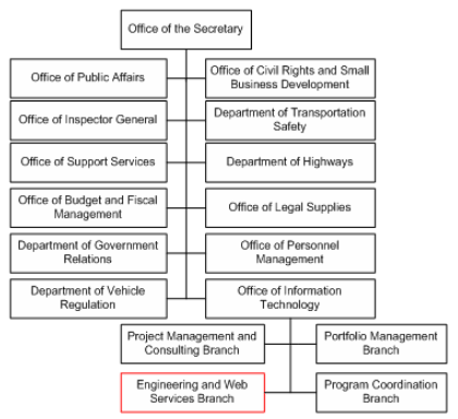
GIS work. In addition to performing these high level functions, such as evaluating new GIS technologies and developing Internet mapping applications, Branch staff have been developing simple desktop GIS templates to facilitate the day-to-day use of GIS since 2000. The GIS templates, which are customized for the various Divisions, are preformatted with the tools and information needed to perform analysis, thereby enabling staff with limited GIS capabilities to utilize the tools. GIS staff within the Engineering and Web Services Branch further support KYTC's GIS users through monthly trainings, consisting of both basic and advanced classes, as well as open lab sessions for customers to address specific problem solving issues.
KYTC's base mapping data collection, including both spatial and non-spatial information, is managed by the Division of Planning within the Department of Highways. The Division of Planning collected centerline data on all public roads using Global Positioning System (GPS) technology and is currently contracting out data collection efforts for all non-state roadways. In the past, the Division of Planning produced a large number of static map series for internal use, but now, due to the availability of internet mapping sites, staff has the ability to develop project specific maps instead of relying on pre-printed maps, which has greatly reduced Planning staff's mapping activities.
Over the past several years the use of GIS has started to diffuse throughout the agency. Currently, there are 240 desktop GIS users sharing 35 ArcInfo and 40 ArcView pooled licenses. Users are spread throughout the Cabinet including staff within the Environmental Analysis, Maintenance, Geotechnical, Program Management and District Offices. Some branches have changed their business procedures so as to more efficiently utilize spatial information. For example, the Geotechnical Branch requests that its contractors provide drilling information with Latitude/Longitude so that it can be incorporated more efficiently with other information.
Data Accessibility and Delivery
KYTC uses ESRI technology to internally disseminate its geospatial data. KYTC's data is shared externally with its partners and the public via several statewide programs. The Commonwealth's Division of Geographic Information (DGI) serves as the central office responsible for the dissemination of spatial data between state agencies. DGI maintains KYGEONET,34 a Geospatial Data Clearinghouse for Kentucky, which includes a variety of statewide metadata and a number of static map products. As a complement to the site, the Kentucky Geological Survey of the University of Kentucky maintains KGSGeoPortal,35 an internet service that allows users to search for a variety of Web-based information about Kentucky's landscape, environment, resources, and infrastructure by geographic extents.
Challenges
Some challenges that KYTC has faced in implementing GIS activities are:
- Limited financial investment - KYTC's executive leadership has supported the ideas and efforts of GIS technical staff. They have invested in elements of spatial technology as budgeting allowed, however, due to the continual shrinking staff pool and financial resources that is occurring across all of state government, KYTC has not be able to fully implement the technology
- Continuing education of staff and management - GIS continues to be limited by the lack of understanding by both new technical staff who do not fully realize the technology's potential, as well as the Executive leadership who does not understand what types of questions the technology can answer. KYTC's GIS staffs continue to focus on educating both groups on the capabilities of GIS.
- Coordinating updates to spatially referenced data - When transportation activities occur that change the location of spatially referenced data, the new information needs to be updated in the various databases. KYTC has a number of independent databases that are maintained by various Divisions and often times updates are not made in all databases, resulting in inaccurate data. While the Engineering and Web Services Branch encourage the staff to communicate any changes affecting spatially referenced data, they lack the concrete authority to require staff to follow specific procedures.
Key Success Factors and Recommendations
- Provide business staff with the skills and tools to effectively utilize GIS - Staffs located in the various divisions understand their core business needs better than IT staff within the Engineering and Web Services Branch. As a result, rather than performing GIS activities in one central office, KYTC finds it more effective to provide its division staff with the tools and the knowledge base to successfully use GIS to meet their specific needs. At the same time, KYTC maintains responsibility for support/coordination and training functions within the IT Engineering and Web Services Branch.
Louisiana Department of Transportation and Development Case Study
Contacts: Doug Albert
DougAlbert@dotd.la.gov
CJ Marchand
CMarchand@dotd.la.gov
Jim Mitchell
JimMitchell@dotd.la.gov
David Ringuette
DavidRinguette@dotd.la.gov
Background
The Louisiana Department of Transportation and Development's (LA DOTD) GIS program evolved out of earlier automated, CAD-based systems that had been in place since the 1980s. With increased high-level support beginning in 1998, the DOTD began to emphasize the importance of GIS for data analysis and not just mapmaking. DOTD then focused on expanding, advancing, and formalizing an IT-centric program. At that time, the only major use of GIS in the Department was in Planning and Programming. Because of its limited scope and primary focus on mapping to support planning, it was decided that the proper location for a geospatial program was the IT section. The primary reason for this decision was that locating GIS in the IT section would best support an enterprise GIS. In 2001, GIS positions were increased (adding on three full-time employees) in the Department's IT section, resulting in a total of five full-time staff. LA DOTD's GIS currently supports a broad spectrum of users throughout the Department, and relies on sustained training efforts to encourage user autonomy.
Business Model for Geospatial Technology Implementation
Organizational Structure
LA DOTD's GIS program is located in the IT Department (see Figure 12). A small staff of five full-time employees supports several hundred DOTD GIS users throughout the DOTD, with additional support to hundreds or thousands of internal and/or external users via web-based services. The Department employs a user-driven business model: users can access desktop versions of GIS applications to create their own maps and perform data analyses, but all data are stored in a central, IT-maintained repository.
Figure 12. Organization Chart for the Louisiana Department of Transportation and Development's Information Technology Section, GIS Unit
The GIS unit has several major responsibilities, which include:
- managing periodic software upgrades
- maintaining a central group of servers and databases to support an enterprise GIS system
- providing technical support to users upon request
- providing extensive GIS training to encourage an autonomous user base
LA DOTD does not anticipate that the GIS program will experience any major organizational change in the immediate future. The philosophy of implementing enterprise GIS is to put the tools of GIS into the hands of professional staff. Staff members are then encouraged to take advantage of training to learn how to use GIS software to do their work; furthermore, as users gain more experience and interest in GIS technologies, they will have access to more training.
DOTD is entering the final stage of GIS implementation, which is the development of server-based, "canned" applications. These server-based applications will serve two purposes. First, the applications can provide users who are unfamiliar with GIS and novice GIS users with advanced functionality and a minimum of user involvement. Second, server-based applications can facilitate repetitive tasks that involve complicated, multi-step GIS processing, since users can perform tasks with relatively simple input. Server-based applications will be implemented as a last stage because without an educated and capable user-base, it is impossible for an IT GIS staff to conceive or implement useful applications for users who have no understanding of geospatial processing.
Training is the foundation of GIS implementation at DOTD. The Department offers a two-day, in-house introductory workshop to educate all levels of users on applications and spends about $35K annually on ESRI training courses and other training materials.
Geospatial Data Acquisition
Data are acquired through multiple federal and state sources; additional data are purchased from third parties, such as Tele Atlas. The Louisiana GIS Council (a state board to coordinate GIS activities) took has funded and acquired two full sets of statewide orthophotographs in both 2000 and 2004. None of these photographs have been used to update base maps or GIS data. In addition, the Federal Emergency Management Agency (FEMA) has supported state-level collection of LiDAR (Light Detection And Ranging) terrain data to enhance the production of Flood Insurance Rate Maps for the national Flood Insurance Program (also housed at DOTD).
Hurricane Katrina influenced data collection and mapping projects, and efforts now focus on revising US Geological Survey (USGS) maps to include post-hurricane data. DOTD has been the state participant in the USGS cooperative topographic mapping program. For example, LA DOTD worked closely with the Army Corps of Engineers to update levee elevation data, which will be used to support a levee database and inspection system.
Many of LA DOTD's data were digitized from extant paper maps created by the USGS. However, the Department estimates that nearly 96% of these paper maps are 5 years or older, so any data derived from the maps are also outdated.36 There is a significant need at the state level to move away from updating paper maps (which is very expensive) to updating digitized maps with new orthophotographs (a much more efficient and cost-effective proposition). To further such photo-revised mapping efforts, a set of orthophotos was taken after Hurricane Katrina. Despite the state's efforts to capture statewide digital orthophoto quadrangles (DOQQs) in 2000 and 2004, and the post-Katrina/Rita coastal DOQQs, none of these data have been translated into updated GIS or paper map products. These photos provided important contributions, but ultimately, a comprehensive state-level effort to update geospatial data must support such ad-hoc projects.
Data Delivery and Policies
LA DOTD maintains a centralized GIS data server/repository as well as 50 ArcView and 20 ArcInfo seats available to some 200+ users across the Department. Some applications, including ArcIMS and ArcGIS Server, are publicly-accessible and available online. Other data are available on the DOTD's intranet and are accessible only to internal staff. The majority of data are shared (both internally and with the public) upon request. Primary users come from all locations through LA DOTD, including Planning, Pavement Management, Safety, Engineering, Emergency Operations, ITS, Surveying, Public Relations, and Public Works. In addition, the Department works closely with other agencies to share GIS data to support state-level emergency preparedness. Data are also shared with the state GIS Council37, a governing body comprised of 25 member agencies from all levels of government and other organizations. The Council monitors state-level data collection to eliminate redundancy, promotes GIS development, and makes recommendations regarding standardization, data purchases, and technology implementation.
As previously noted, the Department's final stage of GIS implementation involves development of web-based server applications with access to all enterprise data via the internet. This effort will complement thick-client, desktop applications by providing easy access to repetitive, complicated GIS tasks. Because of the emphasis on GIS training opportunities for all staff, DOTD has developed a population of knowledgeable GIS users-an important part of the Department's professional development efforts.
Funding
Several state agencies share costs for (non-GIS) staff training, data collection, and data digitization. The DOTD budget also supports funding for other GIS-related activities, such as professional conference travel for GIS staff and users. While it is difficult to estimate total costs for GIS activities, the figure most likely approaches $1.0M.
Benefits
LA DOTD has not completed a formal cost-benefit analysis for GIS. Rather, benefits are articulated in terms of how GIS can contribute to more comprehensive public policy, transportation management, and emergency preparedness.
The difficulty of determining costs and benefits from an enterprise GIS implementation derives from the fact that the costs may be centralized in other programs as IT, staff training, etc. At the same time, the benefits of implementing an enterprise GIS may appear as an array of better decisions and/or more efficient operations, which may not be measurable (at least in quantitative terms) and may accrue in business units where such activities do not incur a cost. The bottom-line is that costs may be separated from benefits when implementing an enterprise GIS, and any costs must be considered as part of the overall cost of doing business.
Challenges
LA DOTD has encountered several challenges in growing a GIS program, but one major challenge is:
- Outdated maps and data - Having access to updated data is crucial to building coherent, current transportation policy and management systems. However, maintaining an updated digital database has not been a national priority, and road data in particular are dynamic and quickly become outdated. Updates of commercial products are infrequent (perhaps twice a year), and this infrequence has significantly limited LA DOTD's ability to make good transportation decisions.
- Limited funding - The Department has worked to expand the state's ability to update digital data. It is difficult, however, to find the necessary funding at the state level, since in the past, federal agencies (like USGS) have leaned heavily on states for financial support with mapping projects. To address these challenges, LA DOTD's Public Works Section recently requested $10M for the 2008 budget, to help update digital data and paper maps.
Key Success Factors and Recommendations
- User training - Training all DOT employees to be GIS-proficient is a crucial step to facilitating a more efficient and proactive GIS program. Extensive, well-organized training encourages user autonomy and increases user comfort with GIS. A trained user base allows GIS staff more time to focus on data and system maintenance, and program expansion, and limits the amount of time that IT-GIS staff might spend responding to users' requests for easily-obtainable information. Moreover, trained users will likely use GIS independently to meet their own needs. It is important to note that training does not always have to come from the DOT itself; the annual GIS-T (Geographic Information Systems for Transportation) symposium is one example of a valuable supplemental learning forum.
- Centrally-located GIS- Data-sharing is an inherent ability of GIS. As such, when beginning (or growing) an enterprise GIS program, it is important to locate GIS centrally within the DOT IT structure. A centrally-located, IT-based GIS will ensure that as many business units as possible reap the benefit of broadened access to the same data while maintaining data quality and integrity. The customer-focused IT section offers a particular advantage in this respect since it supports the needs of all DOT divisions. The business units can concentrate on what GIS requirements they have to accomplish work tasks, while the IT section can focus on making GIS technology meet users' needs. DOTs should carefully consider the utility of placing GIS within the IT section to ensure maximum data-sharing capability.
- FHWA support - LA DOTD emphasizes the importance of federal-level support for state GIS programs. The FHWA should increase opportunities for its own employees to use and explore GIS programs, perhaps by installing desktop GIS onto federal employees' computers. Increasing GIS visibility (and comfort with the technology) in this manner would help the FHWA understand the important contributions that GIS can make to transportation planning. Federal cost-sharing must occur in order to support geocoding for emergency management and preparedness. In addition to cost-sharing, the FHWA should expand opportunities to participate in data-sharing and digitization efforts with state DOTs.
Maine Department of Transportation Case Study
Contacts: Thomas Marcotte
Thomas.Marcotte@maine.gov
Nate Kane
Nate.Kane@maine.gov
Background
GIS activities at the Maine Department of Transportation (MaineDOT) began in the late 1980s and early 1990s. At the time, various Bureaus within the Department were being increasingly called upon to produce maps to support project decisions. To begin building a GIS, MaineDOT staff started applying data from its mainframe logical network to USGS 1:24,000 scale quad maps that had been digitized - creating a public roads base map. This base map served as the foundation for a number of uses as GIS spread throughout the Department in the in the mid- to late-1990s with the advent of ESRI's ArcView 3 software.
Now, MaineDOT is working to move from its current business model for GIS, which is characterized by dispersed pockets of GIS expertise, to a more focused model that best addresses the needs of the entire Department. With enthusiastic support from executive leadership, MaineDOT is developing a GIS Strategic Plan that outlines an approach for the Department, among other things, to:
- Create a mechanism for identifying data that may not currently have a spatial component and/or be accessible
- Present a process for spatially indexing features of all DOT data and then providing all staff with the ability to access spatial data
- Define different user types based on functions to be performed (e.g. analysis vs. georeferencing)
The Strategic Plan is expected to be completed by April 1, 2008.
Business Model for Geospatial Technology Implementation
Organizational Structure
GIS functions at MaineDOT are not concentrated in one section. Instead, GIS expertise is spread throughout the Department. For example, the Department's Mapping Section is located in the Office of Communications, while the Road Inventory Section - which is a frequent GIS user - is located in the Bureau of Planning. The Environmental Office also uses GIS extensively (see Figure 13).
Figure 13. Maine Department of Transportation Organization Chart Adapted from https://www.maine.gov/mdot/main/documents/pdf/Org_Chart_March2011_names.pdf
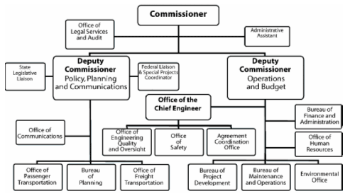
Database maintenance, desktop environment support, and GIS training functions for the Department are managed through the Information Technology Service Center located in a separate state agency called the "Office of Technology," an office in the state's Bureau of Finance and Administration. The Office was created as part of an effort to consolidate Information Services (IS) Offices across the state. In the past, IS staff at the various state agencies - including MaineDOT - were formerly members of their respective agencies' staff. Now, they work for the Office of Technology and bill the agency for which they perform work (i.e. MaineDOT receives a monthly bill for services received from IS staff, including the purchase/installation of new hardware and software). This model has been sometimes challenging for state agencies in Maine due to the fact that decisions regarding their respective IS needs are made at a level removed from each.
Despite the distributed nature of GIS at MaineDOT, GIS endorsement from executive-level leadership historically has been more prevalent than perhaps at other state DOTs. Leadership in both the DOT and the State's Office of Technology have experience in GIS, and the majority of MaineDOT's Bureau and Office managers are advocates of the technology. As such, the importance of GIS as a decision-support tool is well-understood up to the Deputy Commissioner level and has been conveyed throughout the DOT.
Data Acquisition and Availability
Maine transportation-specific GIS data is acquired and managed by departments within MaineDOT. The primary purpose for acquiring this data is to support decision-making through tools that allow it to be easily accessed, analyzed, and reported. MaineDOT departments collect, process, maintain, and distribute transportation information and products utilizing processes and applications built on GIS technology.
Prior to 2006, most of the non-DOT related geospatial data that MaineDOT used was produced by State Agencies within the GIS Executive Council (EC) - a group in which MaineDOT is a member - and the Maine Geo-Library. The EC was chartered in 1996 to coordinate spatial services across State agencies and to negotiate and administer service level agreements between agencies and the Office of Maine Geographic Information Systems (MEGIS).38 In 2006, State technical employees and the services they deliver transitioned to OIT. With the consolidation of information technology functions into OIT, funding of MeGIS core services has shifted from SLAs to the central OIT budget. As a result, the State Chief Information Officer (CIO) has chartered the GIS Stakeholders39 to replace the GIS EC to reflect the shift from a governance body to an advisory role. At the same time, there is a standing need for formal and informal interagency coordination and discussion of all aspects of GIS including best practices, user support, agency business processes, standards, personnel, data management and other GIS-related resources.
Similarly, the Maine Geo-Library, established in 2002 by the Governor,40 was created to introduce a coordinated means for data custodians to organize, catalog, and provide access to geographic information to all levels of Maine's government and to the public. MEGIS now hosts and maintains both of these groups' data on its GIS Data Catalog website.41 MEGIS also hosts several interactive maps - including a statewide orthophoto viewer - available for state agency and public use.42
DOT and State GIS data is available to MaineDOT staff in a myriad of ways. To disseminate and utilize data, MaineDOT has developed public and private web services and applications served by ArcIMS and ArcServer. ArcGIS Desktop is installed on more than 110 computers, and users can access enterprise SDE Oracle databases for the state agencies DOT, MEGIS, and DEP. Transportation personnel also have access to GIS data through the Department's Transportation Information for Decision Enhancement (TIDE) system (discussed in more detail below). MaineDOT has created and maintains a base map of all public highways that includes local roads. The geometric representation and name attributes of private roads can also be accessed via the E911 road dataset that is maintained by MEGIS.
Funding
Overhead from the various Bureaus' biennial budgets is the primary source funding for MaineDOT's GIS activities. Some GIS work is also funded by specific projects, as their needs require.
Applications
Developed in the early 1980s, the Transportation Integrated Network Information System (TINIS) was MaineDOT's location-oriented database that contains most of Maine's transportation system data. Historically, TINIS has been a highly effective system. As MaineDOT's reports:
The data contained within TINIS is of such quality that Maine was one of the five original states selected by FHWA in 1987 to participate in its HSIS (Highway Safety Information System). HSIS is a database that contains crash, roadway inventory and traffic volume data. In order to be eligible to participate in HSIS, states were selected based upon the quality of their data, the range of data available, and their ability to merge data from various files.43
In the late 1990s, MaineDOT acknowledged that the system's ability to perform analysis was a significant constraint. To avoid major business disruptions that may have resulted in replacing TINIS with a modern database, MaineDOT decided to develop the Transportation Information for Decision Enhancement (TIDE), a data warehouse that incorporates all of the TINIS data and some Pavement Management System data. TIDE, which extracts TINIS data weekly, allows staff the ability to quickly correlate previously disparate but related information, as well as to perform trend analyses, and graphically present data. Users can also graphically depict the results of queries they make.
In 2003, Maine DOT launched METRANS (MainE's Transportation Network Solution) to replace TINIS and integrate with the TIDE warehouse. METRANS is a framework built on the software "Highways" by Exor and integrates data from several sources. Maine DOT's statewide highway network is now integrated with spatial (GIS) data. METRANS comprises several enterprise datasets including:
- Highway Inventory
- Traffic Data
- Pavement Management Data
- Crashes
- Rail Crossings
- Project History
- Bridge
- GIS
Challenges
Some challenges that MaineDOT has faced in implementing its various GIS functions include:
- Lack of a unified GIS Unit - Although GIS expertise has permeated most MaineDOT offices, the lack of a unified GIS Unit has sometimes forced the various offices to "fend for themselves" in terms of GIS. There has not been any formal recognition of a GIS effort at MaineDOT. With the strategic planning effort underway, it is expected that this business model will change - perhaps with the creation of a GIS unit.
- Difficulty in identify responsible party at state level for GIS data - At the state level, it has sometimes been difficult for state agencies to identify who is responsible for maintaining and/or providing geospatial data. To date, no agency has been charged with keeping the geospatial data current.
- Shortage of GIS Training - With GIS skills are dispersed across MaineDOT, requests to the Information Services staff (i.e. application revisions) are often variable, depending on the offices' respective business needs. It has not always been possible to have enough cross-trained staff to quickly meet the various and sometimes inconsistent geospatial demands.
Key Success Factors and Recommendations
- Develop statewide base map in parallel with other state agencies and programs, such as Enhanced 911 - The respective base maps that MaineDOT and Maine's Enhanced 911 Program (e911) are based on different database structures and attributes. The e911 database uses unique physical addresses to identify locations. This has been an obstacle to widespread coordination of geospatial data between the two organizations. In the future, MaineDOT may work to conflate the two base map layers.
- Manage GIS centrally - Without a centrally-managed GIS program, it can be easy for an organization to lose track of things such as what applications/activities its various groups have underway, what discrepancies in data interpretation are occurring, if any, and what the different business needs are. By managing GIS centrally from the beginning an agency will be able to better determine how to meet geospatial needs as effectively as possible.
- When making advances, consider alternative solutions - Agencies may often decide to make new applications in the shadow of those developed many years ago without considering options outside a "comfort zone." In these cases, it is important to ask "Is there a better way to accomplish the intended objective?"
Maryland Department of Transportation Case Study
Contact: Mike Sheffer
msheffer@sha.state.md.us
Background
The Maryland State Highway Administration (MDSHA) began collecting geospatial information in the 1980s for an existing Informix database. At the time, most mapping products were Bentley products. Starting in the early 1990s and continuing over the next 5-7 years, MDSHA began contracting with ESRI for ArcView 3.2 software, which offered a repository for standard shapefiles and querying/mapmaking abilities.
MDSHA's GIS program is relatively decentralized, but the SHA anticipates GIS program growth toward an enterprise model in the future. Recent and ongoing projects involve focusing on outreach/marketing efforts to broaden MDSHA's GIS customer base, assessing department-wide data needs to increase data-sharing, increasing the conversion of extant 'flat' file data to GIS format, and setting standards for data collection/requests in collaboration with other state agencies and municipalities.
Business Model for Geospatial Technology Implementation
Organizational Structure
MDSHA's GIS office is located in the Highway Information Services Division (HISD) in the Office of Highway Development. There are four full-time employees in this office as well as eight on-site consultants who work on programming tasks and metadata maintenance. In addition, there are twelve staff members (both state and contracted employees) who work with GIS data to create maps. When making new hires, MDSHA generally looks for individuals with backgrounds in both IT and GIS/geography, and notes the particular importance of demonstrating good spatial understanding.
Maryland counties file Highway Performance Monitoring System (HPMS) submission reports with the State and Local Team within HISD. Previously, the GIS team would update the GIS centerline base to reflect the changing conditions reported via the HPMS submission. Currently, the State and Local Team is being trained to make these updates during their review of the HPMS submission and the Road Inventory Team's validation efforts. This new process will reduce the need for 'handing-off' data between the groups and will clear up any ambiguities or questions that would arise in the past.
The GIS office serves as the department-wide coordinator for GIS activities as well as the main procurer of GIS software licenses, although other departments within MDSHA use GIS and have their own data. In order to build up an enterprise business model in the future, MDSHA would like to increase collaboration and communication between the central GIS office and all GIS users across the DOT.
MDSHA has developed three Strategic Plans for its GIS program, each of which spanned a 4-5 year period, and will likely create a fourth Strategic Plan in the mid-2010s. Together, the three Strategic Plans have provided a backbone for GIS infrastructure. The first Plan addressed the need for data viewer technology to allow basic GIS functions and was completed in the 1999. The second Plan, which was completed in 2000, specified the Department's need for software modernization and vendors. The third Strategic Plan, which MDSHA is currently developing, will specifically address future directions for program growth toward a more unified enterprise model, replacement of current data viewers with more modern software, and methods for more advanced user tracking. Because understanding users' needs is a crucial step towards building an enterprise model, MDSHA has prioritized user tracking.
Data Collection, Delivery, and Policies
Data are collected on an ongoing basis. However, in the enterprise model plan, MDSHA envisions the GIS office as an end-user and consumer of data and not necessarily as a data producer. In the enterprise model plan, the GIS office would primarily provide technical help, quality assurance/quality control, training, and ad-hoc custom data manipulation and mapping work to other users. Toolsets would need to be developed to allow the data producers, other divisions within MDSHA, to geo-enable their data via Extract Translate and Load (ETL) technologies.
GIS users currently come from all parts of the State Highway Administration (SHA) and there is no formalized governance structure for data requests. Notably, some requests have occurred on a cyclical basis (e.g., after a weather-related event), allowing MDSHA to anticipate, to some extent, occurrence of user queries. MDSHA does currently have a limited ability to track its GIS users and is working to increase this capability. Tracking users is important not only for an enterprise model, but also for software updates: MDSHA anticipates that ESRI will soon replace ArcView 3.2 software. In order to prepare for this change, MDSHA would like to understand who is currently using ArcView 3.2 software and how it can help these users migrate to updated software.
A recently-completed primary application (available to internal users) is the SHA Web Map Engine (SHAWME). SHAWME, which is essentially a dataset viewer/catalogue, replaced an older ArcIMS dataviewer that had limited analytic abilities. SHAWME provides internal staff the ability access spatial data (such as accidents, traffic daily volumes, and bridge inspections) for discrete locations. Using SHAWME, the internal staff can also track software users to some extent. SHAWME will be released twice a year, on average, with updated datasets and query functionalities, and also offers robust decision-making support through its sister sites. These sister sites often offer more specialized or detailed information, and MDSHA is working to enhance extant sites and build others to meet the range of users' needs. One extant sister site is the Bicycle Level Of Comfort (BLOC), which uses SHAWME technology to answer questions about future scenarios involving roadways and bicyclers (e.g., how an increase of road shoulder width might affect bordering biking lanes).
MDSHA also uses CAD-based systems to develop tourist and bicycling maps; CAD is used in order to provide a more 'user-friendly' and aesthetically pleasing display for these maps.
Funding
Federal SPR funds support the SHA's GIS activities. The estimated budget for the GIS program in MDHSA is $1M annually. MDSHA has not engaged in a formal cost-benefit analysis to comprehensively assess the GIS program, although it recently completed a Return on Investment (ROI) project with the help of resources from the Geospatial Information Technology Association (GITA). The ROI project looked at statewide procurement of aerial photographs (estimated cost: $3.5M) and concluded that this procurement provided significant cost and time savings to the SHA.
Challenges
MDSHA has encountered several challenges in growing its GIS program:
- Lack of strong centralized authority - Historically, MDSHA has not organized its GIS program around a strong centralized authority and, to a large extent, GIS activities have been completed on an ad hoc basis. Lacking a strong centralized business model, MDOT has also struggled to achieve cross-division consensus on how to proceed with the GIS program. In the past, high-level support has helped provided an impetus for growing specific aspects of the GIS program, but the level of this support has not been consistent, since there has been no strong centralized GIS office to advocate for GIS.
- Asset management - Individual divisions have often taken their own paths to application development and have been fairly autonomous in their use of GIS. While MDSHA would like users to be able to use GIS to meet their own needs, it is important that MDSHA can account for all users' activities as it builds an enterprise system. Asset management is therefore a critical factor in developing an enterprise system, but it is difficult to determine how to efficiently collect information from all users about projects or software/hardware.
Key Success Factors
- Successive Strategic Plans - MDSHA created three successive Strategic Plans (and anticipates creation of a fourth Plan in the mid-2010s). In the absence of an enterprise system, these Plans have provided infrastructure for the GIS program. The Plans' articulation of long-term objectives and goals has generally helped to ground efforts to build the GIS program at MDSHA.
- Collaboration with counterparts - MDSHA participates in the annual GIS-T conference, TRB, and other networking opportunities in order to increase collaboration with its counterparts at the federal, state, and local levels as well as other GIS stakeholders. Interactions at these conferences often take place on an informal basis and allow MDSHA to learn more about GIS best practices, especially regarding the conversion of 'flat' data to digital GIS format.
Massachusetts Executive Office of Transportation and Public Works Case Study
Contact: Mark Berger, Data Resource Manager
mark.berger@state.ma.us
Background
GIS activities at the Massachusetts Executive Office of Transportation and Public Works (EOTPW) began circa 1996 and evolved from maintenance of the state's Road Inventory File (RIF) - a comprehensive, detailed itemization of roads linked to traced line graphs covering the Commonwealth. Before then, the Department tracked and managed information on road features using tabular data. By 2002, this practice had grown into system where new linework is developed from road and rail centerlines interpreted from orthophotography collected for the state.44 Today, the imagery provides a dynamic, high-quality, statewide basemap that EOTPW, with help from its counterpart state agencies such as the Massachusetts Highway Department (MassHighway), regional planning organizations, and municipalities, is continuously updating with new highway features and information.
Business Model for Geospatial Technology Implementation
Organizational Structure
Under EOTPW, the Office of Transportation Planning houses the Data Resources Section, which performs all statewide transportation GIS functions and is located in the central Boston office. Although reductions in staff size have recently occurred, the Data Resources Section is currently comprised of five full-time state employees (down from eight) and approximately two in-house consultants. These staff members come from a variety of backgrounds, but experience in spatial geography and programming is usually indispensable.
Data Resources staff members are primarily responsible for maintaining the Massachusetts RIF and transportation GIS layers such as rail assets, airports, regional transportation agency boundaries, and passenger and freight water facilities. The Data Resource Section also works to provide the Department with the data necessary to prepare HPMS submittals, as well as to offer as necessary training for MassHighway's five district offices.
Data Acquisition and Maintenance
EOTPW acquires geospatial data from the Commonwealth's municipalities, as well as any group or member of the public that identifies new information or points out existing data errors. The Office of Transportation Planning describes the process for updating the RIF on its webpage:
With over 500,000 records in the [RIF], we strive to keep it as current as practical. If a street name is misspelled or if a physical measurement such as the surface width is incorrect, we encourage file users to supply corrections.45
Municipalities submit (via mail) updated road inventory data to Data Resources staff who use orthophotography to crosscheck and verify the suggested revisions. This approach is possible because EOTPW has made it a priority to update the state's aerial imagery. Using funds pooled with the Massachusetts Department of Environmental Protection and MassGIS, the state is flown at least every four years for new orthophotography. There are plans to supplement the latest orthophotography with oblique imagery (aerial photography that is taken at an angle) in the spring 2008.
EOTPW also closely coordinates with MassGIS, Massachusetts' Office of Geographic and Environmental Information that serves as the statewide clearinghouse or archive for spatial datasets.46 In 1999, the state legislature recognized the importance of statewide coordination of GIS activity in the Commonwealth and established MassGIS as the official state agency assigned to the collection, storage, and dissemination of geographic data.47 EOTPW GIS staff members periodically participate in meetings and conferences that MassGIS convenes. Furthermore, EOTPW was a member of the steering committee that partnered to develop a Strategic Plan for Spatial Data Infrastructure in the state.48
Benefits and Costs
SPR funding supports EOTPW's GIS activities. The annual budget, which finances state and consultant staffs' salaries and hardware/software costs, is approximately $1.2M. The return on this investment is difficult to quantify. However, GIS has provided EOTPW with quicker access to critical information, facilitating the processing of tasks such as the HPMS submittal; previously the HPMS submittal would take 4-5 months of constant work, and now it can be completed in roughly 60-70 percent less time. Labor effort savings such as this have allowed GIS staff at EOTPW to spend less time searching for data and more time producing actual applications and analyses.
Applications
One of the more prominent GIS applications that EOTPW has developed is the Road Inventory Interactive System.49 The web-based version of the application gives the public access to the most commonly requested road inventory attributes: functional classification, jurisdiction, ownership, National Highway System designation, and Federal-Aid eligibility. An internal version of the system, which operates from a web-based software package, allows EOTPW staff to maintain and edit the web-based viewer environment without using consultant services.
Other geospatially-enabled applications at MassHighway include a crash record system allowing operations staff to analyze the Commonwealth's most dangerous intersections, and a project information system that links enterprise-wide, project-specific information to geographic information.
Future
While continuing to improve and expand all of its transportation data layers, EOTPW expects to continue its trajectory towards a world of paperless analysis. It is anticipated that effort (and business needs) will be increasingly tied to producing interactive tools accessible to all. The Department is moving away from fielding requests for paper maps to creating a web-services business environment that maximizes end user autonomy.
Challenges
Some challenges that EOTPW has faced in implementing its GIS program are:
- Obtaining widespread understanding that GIS and aerial imagery go hand-in-hand - There is a constant need to update aerial imagery, which provides accurate base layer information for GIS. Increasing awareness about the important relationship between GIS and aerial imagery would reduce the time spent justifying the need to acquire imagery updates every few years.
- Lack of the "latest and greatest" programming expertise - Lack of staff programming expertise can make it difficult to maintain GIS databases in-house. EOTPW would like to have the option of hiring experienced programmers, as well as staff with significant backgrounds in geography/GIS. However, current starting salaries cannot compete with the private sector for hiring quality programmers.
Michigan DOT Case Study
Contact: Joyce Newell, (517) 373-2237
NewellJ@michigan.gov
Cory Johnson, 517-335-1908
johnsonco@michigan.gov
Background
The Michigan Department of Transportation (MDOT) has utilized geospatial technologies since the early 1990s. One of its earliest projects was the Michigan Accident Location Index (MALI), which MDOT took over from the State Police in 1996. MDOT was responsible for updating MALI to meet Michigan's broader needs, including adding marine, nonmotorized and rail segments. Today a number of MDOT's applications include a spatial component used to support the programmatic decision-making process.
Business Model for Geospatial Technology Implementation
Organizational Structure
The Framework and System Monitoring Unit within the Transportation Planning Services Bureau, Asset Management Division (see Figure 14) manages and coordinates MDOT's GIS activities. This unit employs seven full-time staff. Staff responsibilities include formatting the statewide GIS base map for use by MDOT staff, producing maps, data maintenance, preparing the annual HPMS submittal to FHWA, and providing support on projects to ensure the technical requirements of GIS are addressed. The Framework and System Monitoring Unit also develop web applications focused on helping MDOT staff utilize the geographic base map and provide GIS software training. Furthermore, GIS staff play a significant role in GPS data collection and training for obtaining roadway features including realignment drive lines.
Figure 14. Michigan Department of Transportation Organization Chart- September 2007
Michigan has consolidated many of its statewide GIS activities within the Michigan Center for Geographic Information (CGI). CGI provides leadership, technical expertise and policy for the acquisition, development, use, dissemination, promotion and sharing of geographic information in the state of Michigan. MDOT has staff that work at CGI to ensure that transportation geospatial data needs are being addressed in statewide GIS projects. In addition, MDOT staff members regularly attend the MGI Users Forum, a monthly meeting for GIS users from all areas of the state to come together and discuss issues pertaining to GIS activities in Michigan.
Spatial Data Acquisition and Availability
Throughout the 1980s and 1990s several Michigan state agencies, including the Department of Transportation, the Department of Natural Resources (DNR) and the Michigan Information Center (MIC), were each developing their own base maps. This resulted in significant duplication of efforts. In addition, the data that each agency collected was largely inaccessible for broad use throughout the state. Acknowledging that each state agency was developing very similar products, the DOT, DNR, MIC and a number of additional state, regional and local agencies decided to pool their resources to create one base map for use by all. Now the Michigan Center for Geographic Information (CGI) maintains and updates the state's official GIS base map, the Michigan Geographic Framework, and distributes it to state agencies and its partners annually. The map contains all of the themes most commonly used in applications including transportation, hydrography, government boundaries, and geodetic control. When MDOT's Framework and System Monitoring Unit receives the annual Geographic Framework from CGI, staff members reformat it into various formats it into various levels of detail and makes it available to all MDOT staff via a central server.
In addition to the Geographic Framework, CGI also maintains a web interface that provides access to statewide datasets, online maps, query tools, and imagery. The creation of the Framework and CGI's coordination of statewide GIS activities have lead to significant cost-savings due to reduced duplication of efforts, as well as improved access to a variety of spatial data.
Data Delivery
Nearly all of MDOT's enterprise data, with the exception of proprietary data, is available to both internal staff and other state agencies. MDOT staff access spatial data through a number of applications including the Physical Road (PR) Finder, a web-based application that allows users to easily locate and gather PR linear referencing information. Other users of spatial information include the Asset Management, Operations, Environment and Safety Divisions.
Funding
MDOT receives funding for its GIS activities from FHWA's State Planning and Research (SPR) Program. A portion of these funds are used to supplement MDOT's funding obligation to CGI. CGI assesses fees to each of the departments that utilize its enterprise system. Because MDOT is one of the largest users of CGI services, its annual assessment is among the highest. MDOT's annual assessment is $600,000.
Challenges
Some obstacles that MDOT has encountered while growing its GIS program include:
- Legacy Data: There are a small number of legacy systems that have not yet been updated to the department's current standards for data and application management. Some MDOT divisions are reluctant to accept a new spatial referencing system because it represents a change to a system that they are comfortable operating within.
- Managing multiple GIS systems: MDOT currently operates two GIS systems. Caliper is the official platform for the DOT but CGI's Framework relies on ESRI software. While MDOT may increase its use of ESRI products in the future, it has no intention of abandoning Caliper because it provides the functions that best meet its business needs. However, supporting both software products requires additional staff time to manage and support the dual system.
Key Success Factors and Recommendations
- Develop support through pilot projects: MDOT began its GIS activities by focusing on a one-county pilot project. By demonstrating the capabilities and benefits of using GIS on one initial project, the GIS staff was able to secure the financial and operational support needed to fully develop the GIS program.
- Pool resources with partners: The Michigan Center for Geographic Information has played an integral role championing the use of GIS throughout the state. By pooling resources and sharing expertise with one another, state, regional and local agencies are able to utilize GIS in ways that they would not be able to do independently of one another.
- Train staff on using GIS technology: MDOT has focused on training staff to use the available GIS technology and resources. The GIS Section has offered GIS training to every region and division. In addition, staff members provide on-going support to the end users to ensure that the GIS resources are up-to-date and useful. As a result, the end users have become advocates for the enhancement of spatial activities.
Minnesota DOT Case Study
Contact: Dan Ross
dan.ross@dot.state.mn.us
Background
The Minnesota Department of Transportation (Mn/DOT) began using CADD-based systems in the early 1990s to support cartographic work. At the same time, Divisions began exploring the use of GIS on an ad hoc basis to support individual projects. In 1996, Mn/DOT digitized the state's USGS 1:24,000 topographic paper maps to create digital base layers for use in a GIS system. This work was completed using internal resources and temporary staff. In 2000, high-level management created a centralized support group for GIS services. Over the past 10-15 years, Mn/DOT has continued to provide a core set of planning-level GIS layers and has significantly expanded its GIS program. Furthermore, Mn/DOT is working to develop and move toward a web-based enterprise GIS system.
Business Model for Geospatial Technology Implementation
Organizational Structure
Initially, GIS activities were located in within the Engineering Services Division. In 2000, a core GIS Unit was created as part of the Program Support Group, which became part of the Planning, Modal and Data Management Division in 2005. Later, the GIS Unit was moved into the Office of Decision Support (ODS), which also houses the Department's IT group (see Figure 15). The core GIS/IT support group has seven full-time employees, all of whom have 'Information Technology' classifications. The GIS group's primary responsibilities are to consult across the organization to provide statewide GIS direction, design, and programming and project support. Other large GIS functional areas include Mn/DOT's Metro District and Offices of Land Management (OLM) and Transportation Data and Analysis (TDA), all of which employ full-time GIS professionals. The GIS professionals in the OLM and the Metro District fall under an IT classification; staff in the TDA Office are classified as 'Research Analysts' with a focus on data maintenance.
Mn/DOT has pooled licensing for all GIS applications. There are currently 844 desktop installations of GIS across the Department. An electronic enterprise-wide license manager tracks each user at login and coordinates utilization of pooled licenses. Users are located department-wide, including in Mn/DOT's eight District offices. Two of Mn/DOT's District Offices employ GIS coordinators who serve as the primary support mechanism in their respective districts.
Currently, Mn/DOT is in the process of writing a three-year strategic plan to establish guidelines and framework for moving towards an enterprise GIS system. As part of the enterprise development process, Mn/DOT plans to replace legacy systems with updated services and applications. There has been some conversation at the state level about acquiring a state enterprise software license, which would help to facilitate this development process. As a long-term goal, Mn/DOT expects to move away from desktop GIS applications to web-based technologies. The Department anticipates that the number of GIS users will increase as a result of this move.
Figure 15. Minnesota Department of Transportation Organization Chart, November 2007
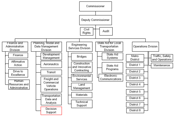
Data Collection, Delivery, and Policies
Mn/DOT generates some initial highway data for construction projects using Light Detection and Ranging (LiDAR) technology and photogrammetry methods. There is a desire to do more of this work in the future. Several business areas (including the Districts, the OLM Office, and the Offices of Bridges and Structures, Environmental Services, and TDA) create and maintain data for use in the organization. In addition, Mn/DOT obtains data from other state, federal, and local partners and agencies (e.g., the state Department of Public Safety and the Bureau of Land Management). Traffic information and video log data are collected on an ongoing basis. Most recently, Mn/DOT purchased mobile GPS units to supplement the Department's field data collection efforts.
The Minnesota Spatial Data Infrastructure50 (MSDI) serves as a formal statewide standard for data-sharing and the Minnesota Geographic Data Clearinghouse (MGDC)51 encourages voluntary data-sharing across the state. Mn/DOT also supports internal and external data-sharing. Several Mn/DOT datasets and data layers are publicly-accessible via a web viewer and map services and data, including information regarding roads and reservation boundaries, are shared with tribal entities across the state.
Mn/DOT's primary internal GIS customers are the Districts, the OLM, and Offices of Traffic, Safety and Operations, Environmental Services, and Maintenance. The enterprise GIS Unit supports many business areas by providing a central spatial data warehouse and common data access tools. For example, the warehouse includes road, Right-Of-Way (ROW), and geodetics information, boundaries, roads, traffic, some imagery, and crash data. In the future, Mn/DOT anticipates adding information for assets, utilities, as-builts, and other functional data. Geotechnical staff within the Offices of Materials and Environmental Services use GIS to post findings (e.g., soil borings). The Hydraulics group uses a recently built GIS system with a mobile interface to collect information in the field as well as a web browser to provide user access to hydraulic data.
The GIS Unit built a Common Operating Picture (COP) for the August 2007 I-35W bridge collapse and has provided GIS-specific applications for several DOT business areas. For example, Mn/DOT developed the Geodetic Monument Viewer,52 which contains information on permanent geodetic control marks in Minnesota, and the Statewide Archaeological Predictive model,53 which assists transportation planners in archaeological site avoidance and roadway design. Mn/DOT uses both CADD and GIS-based applications, but each has functionalities to allow interoperability. Most recently, Mn/DOT deployed a system that will allow users to obtain imagery from a service for use in both GIS and CAD systems.
In 2005, Mn/DOT developed and deployed a web template for viewing interactive maps that supports Mn/DOT's 13 web-based applications. The Department's major web-based application is the enterprise geospatial warehouse and associated Mn/DOT Interactive Basemap,54 which stores 40 core data layers. Current efforts involve migrating from ArcGIS 9.1 to ArcGIS 9.2 software, maintaining road data for all public roads in the state, increasing internal and external data-sharing, and improving the connectivity of various mapping applications with business systems. Over the next several months Mn/DOT will be designing, developing and deploying an enterprise GIS portal.
The enterprise GIS Unit provides extensive GIS support to Mn/DOT users throughout the state. For example, the GIS unit coordinates a one-day introductory class, which is held several times a year. While the introductory class does not focus on hands-on training, it is designed to provide users with an overview of how to access GIS resources. For hands-on training, Mn/DOT uses vendors that provide certified GIS training. The office has a support page that users can access if they require help; users can also submit a form (available on Mn/DOT's webpage) to the office to request assistance on specific issues. The office currently receives between two to four forms a day, which are sent first to the IT help desk and are then electronically routed to GIS staff. In addition to these efforts, Mn/DOT coordinates several meetings a year with higher-level GIS Coordinators (a group comprised of eight to ten individuals) and Key Users (a group of 40-50 individuals). A separate GIS developers' group also meets to focus on technical/development issues.
Funding
Most of Mn/DOT's GIS development effort is funded through IT project development accounts; Division directors determine how IT funds are allocated to all IT projects. Research investments, including some FHWA funding, have been used to design several GIS-based applications for specific project support purposes. One example of an FHWA-funded task is the Intelligent Compaction project, which uses geospatial data to display underlying roadbed stiffness and uniformity for pavement condition studies.
Mn/DOT estimates an annual budget of $500K to $750K for its GIS activities, which includes staff resources and project development dollars. The Office of Decision Support funds maintenance and purchasing of software/hardware and product licenses for an additional $150K/year, although the number of purchased licenses varies from year to year.
Challenges
The primary challenges that Mn/DOT has encountered while developing its GIS program are:
- Need for increased resourcing - The GIS office does not have sufficient full-time staff to pursue marketing opportunities and to respond to all business users' requests. Furthermore, due to limited resources, the office has had to curb its GIS user training programs. Insufficient staff and resources have limited GIS program growth. In the past, the organization has provided dedicated efforts to train large numbers of users of GIS technology and at one point trained nearly 300 users within the span of a year. Currently, training is conducted less often (approximately 4 times a year).
- Ongoing development of an enterprise model - Development of an enterprise system/approach for GIS in the organization is an on-going and challenging process. The current business model within the Mn/DOT is a decentralized "office specific" model: each business area that uses GIS is responsible for maintaining its own data, developing its own standards and procedures, and managing its own personnel resources. However, Mn/DOT is now working to move towards an enterprise system.
Key Success Factors and Recommendations
- IT location - Locating the GIS program in an IT office has increased the program's visibility and staff access to resources. Staff members now have an ability to review all potential IT projects, which makes it easier to determine how to best allocate resources for GIS applications and meet users' business needs. Finally, aligning with IT has allowed GIS staff to focus on GIS rather than on hardware and database maintenance.
- Continued interest and investment in GIS technology - Since the initial investments in GIS technologies during the 1990s, Mn/DOT has continued to provide strategic investments in GIS. Although this investment has not always been at an optimal level to maximize returns, progress has continued.
- Increasing connectivity - To improve internal and external access to information, Mn/DOT has worked to make its applications web-accessible. Improving application connectivity has increased the GIS program's visibility both in and outside the DOT and facilitated user autonomy.
Mississippi DOT Case Study
Contact: Ray Barksdale, (601) 359-7206
barksdale@mdot.state.ms.us
Background
GIS activities at Mississippi Department of Transportation's (MDOT) first began around 1994 during the development of its Transportation Management Information System (TMIS), now one of the Department's most prominent GIS applications. At the time TMIS, a system that provides access to bridge, pavement, safety, and traffic data all linked by a common LRS, was developed to support an array of MDOT's business needs. However, it became apparent that the application, which is now being phased out, primarily supported pavement analysis and maintenance activities and did not offer sufficient spatial analysis abilities to everyone.
As the utility of geospatial analysis became more known to staff outside MDOT's Planning Division, MDOT began considering how GIS responsibilities and applications - including TMIS - could be better aligned with Department-wide needs. The solution was to move GIS functions from the Planning Division to the Information Systems Division, a group that operates independently - but in support - of MDOT's other various business divisions. However, MDOT found that this organizational structure hindered coordination between staff working with GIS and other staff, such as the Department's engineers. In response, MDOT conducted a significant study effort to more fully investigate and assess the issue. Based on the study's findings, a new division was created - the Division of Transportation Information (DTI) Division - to coordinate the enterprise distribution of MDOT's GIS support. Now, the DTI Division works closely with the Planning Division (the division responsible for maintaining the road network) and the GIS Support Team (an information systems group responsible for computing infrastructure) to provide GIS services to all within MDOT.
Business Model for Geospatial Technology Implementation
Organizational Structure
MDOT's DTI Division is located within the Office of Highways, an office comprised of multiple sections involved in the design and construction of Mississippi's highways (see Figure 16). Both MDOT's GIS specialists and a majority of its GIS end users are located in the Office of Highways, encouraging close and frequent coordination between the groups.
The DTI Division has a staff of five full-time employees. These staff are chiefly responsible for developing applications and providing as-needed analysis services. Currently, the DTI Division's largest staffing need is for basic tech work such as digitizing and data acquisition, and MDOT is exploring the possibility of hiring contract or student workers to perform these duties. Given the limited size of the DTI Division, its data acquisition activities are supplemented and supported by staff in other MDOT Divisions. When working to obtain or create data for a given Division's project, the help of staff members from that stakeholder Division is recruited. In addition, once the data are created, the responsibility for data maintenance is transferred to the targeted Division.
MDOT expects that as its GIS program advances, there will be an increasing need for staff to have an IT/programming background. Although currently there are physical space constraints for hiring new staff, there are plans for the DTI Division to grow into a new floor and once relocated, to new offices for the dissemination of GIS personnel into other MDOT divisions. In both scenarios, it is anticipated that a person with an IT background would more easily be able to create or manipulate geospatial applications to meet project needs, than for a person with a purely geography-centric background to learn or perform the necessary programming.
Figure 16. Mississippi Department of Transportation Organization Chart
Geospatial Data Accessibility, Acquisition, and Delivery
MDOT depends on a wide range of sources for its geospatial data. Much of the data are produced internally, either by DOT staff or consultants. Operations, maintenance, and safety staffs are each equipped with GPS devises to collect location data as part of their on-going responsibilities. The accuracy of the field-collected information is assessed based on a review of the collection procedure used.
In addition to internally-developed geospatial data, as well as data sometimes purchased from third-parties, MDOT uses data from a multitude of trusted sources, including federal, state, and local government agencies. One state resource MDOT actively engages is the Mississippi Automated Resource Information System (MARIS).55 MARIS serves as the legislative mechanism within Mississippi state government to provide for the availability and use of digital natural and cultural resource information. Additionally, in 2003, the Mississippi Legislature created the Mississippi Coordinating Council for Remote Sensing and Geographic Information Systems (MCCRSGIS),56 a group responsible for creating statewide coordination and sharing of geographic data. MCCRSGIS also oversees the development of the Mississippi Digital Earth Model (MDEM), a digital land base computer model of the state.
Although, a public portal to its geospatial data is not currently maintained, MDOT's geospatial data are shared enterprise-wide and available upon request. Before making the data widely available, the Department intends to obtain more up-to-date and accurate information than it currently possesses.
Funding
MDOT's annual budget for the DTI Division's activities is approximately $650,000. A majority of this amount comes from federal state planning and research (SPR) funding. MDOT's Safety Analysis Management System (SAMS) is supported through FHWA safety funds, while the Maintenance Management System (MMS) is funded by maintenance funds.
Challenges
Some challenges that MDOT has faced in implementing GIS activities are:
- Lack of job classification for 'GIS Specialist' - The Mississippi State Personnel Board, the agency responsible for state government hiring in Mississippi, does not currently have a 'GIS Specialist' job classification. As such, when hiring for GIS positions, MDOT staff often spend unnecessary extra time working with the Personnel Board to craft new job announcements seeking GIS qualifications. The state's MCCRSGIS is currently working to develop a set of recommendations on how to define the GIS job classification and will present this to the State Personnel Board.
- Changing the perception of what GIS is within the Department - MDOT's GIS managers must constantly work to encourage others at MDOT to view GIS as simply another "tool in the toolbox," and not as a "scary" or overly-substantial technology. GIS staff members continue to teach others in the Department that all MDOT data have a geospatial component and that GIS is just one tool allowing for the viewing and analysis of that information.
- Creating a statewide cadastral layer - Many of Mississippi's 82 counties are extremely rural, and in some cases a county may only have a handful of computers. It is sometimes difficult to work with the counties (and their consultants) to acquire or create geospatial data sufficient enough to meaningfully contribute to MDOT's transportation decision-making efforts.
- Building a multi-level LRS - MDOT currently has three LRS, which are basically copies of each other. TMIS has the road network maintained in a set of CADD files, while planning maintains one LRS in Oracle Spatial (GIS) and a third for SAMS also stored in Oracle. Planning uses a Linear Referencing Model (LRM) composed of county, route and logmile, while SAMS utilizes statewide cumulative mileages. MDOT is looking into creating a Multi-Level Linear Referencing System (MLRS) that has a single datum (linework and mileages) that may be referenced by multiple methods. Planning would maintain the underlying datum; this is the GeoTrans model that is based on the NCHRP 20-27 model.
- Collecting accurate data from the field - MDOT is developing a Safety Analysis Management System (SAMS), which requires a statewide inventory of the roadway system and roadway features. It is one of the most complex GIS projects MDOT has undertaken. As part of data collection for the project, MDOT field staffs, including those in other state agencies such as the highway patrol, have been asked to record the location of various attributes using GPS as part of their day-to-day activities. It has been MDOT's experience that sometimes those in the field fail to accurately take the GPS measurement, if it is taken at all (i.e. some forget, others have found it too dark at night, while others have confused local names with state designated names). MDOT continuously works to train staff in the proper use the GPS equipment.
Nebraska Department of Roads Case Study
Contact: Rose Braun, (402) 479-3696
rose.braun@nebraska.gov
Background
The Nebraska Department of Roads (NDOR) has been utilizing geospatial technologies in its planning activities since the early 1990s. Initially, all aspects of the GIS program, (including data collection and maintenance, spatial analysis, and map production) were organized within NDOR's Planning Division. However, in the early 2000s, the Planning Division was disbanded and its responsibilities were reorganized within various NDOR Divisions.
Business Model for Geospatial Technology Implementation
Organizational Structure and Applications
NDOR's GIS Section and the Geo-Spatial Support and Development Section, are located within the Business Technology Support (BTS) Division (see Figure 17). The GIS Section is responsible for creating and maintaining the transportation system geo-spatial base map and assisting NDOR staff in using GIS to meet their business needs. This section is also responsible for mapping state, county, city and special maps. The GIS Section has a staff of 11, which consists of 1 GIS manager, 2 GIS analysts, 1 Application Developer, 5 Cartographers and 2 temporary student work studies.
Figure 17. Nebraska Department of Roads Organization Chart
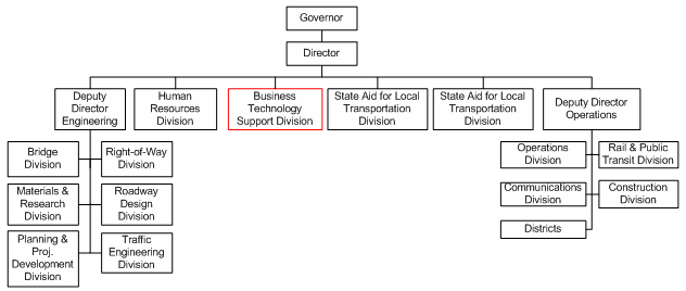
In addition to the GIS Section's work, NDOR's GIS activities are supported by staff throughout the Department. Geospatial applications and software are maintained by the Application Development Section within the BTS Division. The Data Warehouse Section, also within the BTS Division, provides and maintains access to NDOR's enterprise data. The majority of NDOR's spatial data is collected by the Materials and Research Division; however other Divisions, such as the Planning and Project Development Division, collect additional spatial data that pertains to their areas of interest.
NDOR's GIS end users are located throughout the Department including the Roadway Design, Construction, Bridge and Operations Divisions. Most recently, the GIS unit has begun working with the Right-of-Way Division on a pilot project to incorporate its large amount of data, currently available only in paper format, into GIS. The Environmental Unit (within the Planning and Project Development Division) performs its own GIS activities, since it is the only NDOR Division that operates within the ESRI platform (Intergraph is NDOR's primary GIS platform).
Data Availability and Applications
In addition to the large amount of spatial data collected internally, NDOR relies on state agencies and its local partners for additional spatial data. The County Highway Superintendents provide updates to NDOR on any changes to the networks located within their county. NDOR also works with state agencies, (such as the Department of Natural Resources, the Game and Parks Commission, and the Nebraska State Patrol), through the Nebraska Geographic Information Systems Steering Committee. Their role is to see that public investment in GIS technology is achieved in a coordinated and efficient manner. The Committee is currently working on developing a Nebraska enterprise-level geospatial data exchange network that will allow agencies to access up-to-date data from multiple public agencies.
Currently, access to NDOR's spatial data is restricted to internal staff. One of NDOR's biggest GIS applications is the Nebraska Enterprise Centerline Transportation Attribute Resource (NECTAR). NECTAR is a web-based tool that provides access to data pertaining to roads, bridges, railroads, average daily traffic (ADT) locations, maintenance activities, guardrail locations and a variety of other transportation data that was not easily accessible in the past. Within NECTAR, users can query multiple databases and generate maps and reports.
In addition to NECTAR, NDOR has created CoNECTAR. CoNECTAR provides local jurisdictions with user-friendly access to local agency transportation related information. County agencies can upload transportation related information, such as sign, culver or bridge data, which then can be accessed by county employees to create dynamic maps using county and state data.
Funding
NDOR receives funding for its GIS activities from FHWA's State Planning and Research (SPR) Program.
Key Success Factors and Recommendations
- Collaborate with Peers in Other States - NDOR's GIS Unit regularly works with peers in surrounding state DOTs to address and resolve shared GIS issues. NDOR is currently partnering with the Washington Department of Transportation (WSDOT), Oregon Department of Transportation (ODOT), Ohio Department of Transportation (ODOT), and the Tennessee Department of Transportation (TDOT) on developing computer based tools that facilitate geospatial transportation data sharing and integration among a variety of sources.
- Market GIS Resources to Staff - Many NDOR staff are not aware of the range of spatial data and applications that is available to them, and thus do not take full advantage of the GIS resources on hand. The GIS Unit has made marketing its GIS capabilities a priority. Staff are using a variety of communication strategies, such as emailing monthly GIS tips and tricks and hosting user group sessions for staff from different Divisions to come together and share information on how they use GIS.
Nevada DOT Case Study
Contact: Eric Warmath, (775) 888-7265
ewarmath@dot.state.nv.us
Background
The Nevada Department of Transportation (NDOT) initiated its GIS program in the mid-1990s and located its GIS Section in the Location Division within the Planning Directorate. In addition to the GIS Section, the Location Division includes the Survey, Photogrammetry, Geodesy, Cartography and Imagery Sections. A departmental reorganization resulted in the Location Division being transferred from the Planning to the Engineering Directorate. At this time, NDOT made a decision to keep units within the Location Division intact, as many of the units' job functions supplemented each other or were part of the same workflow.
Business Model for Geospatial Technology Implementation
Organizational Structure
NDOT's GIS Section is located within the Location Division under the Engineering Directorate (see Figure 18). The GIS program is outlined and supported by a Departmental Policy for GIS. Historically, the GIS Section has operated with a staff of two full-time employees (one program manager and one technician); however, more recently, two additional GIS technical staff positions have been approved. The GIS Section is responsible for the interdepartmental coordination of GIS activities, which includes setting minimum data standards and coordinating these standards across the DOT, maintaining enterprise software, collecting, developing, and maintaining data layers for the base map, providing training to end users, developing enterprise applications, and coordinating with federal, state, and county agencies on data development and sharing. NDOT has relied on contractors to build the applications, manage some projects, and to a smaller extent, perform some data collection.
Figure 18. Nevada DOT Organization Chart
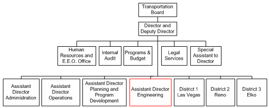
In addition to the GIS Section, various NDOT workgroups contribute to NDOT's GIS activities. The Geodesy Section is responsible for validating the spatial accuracy of the GIS data, while the Cartography Section is responsible for NDOT's cartographic map production. NDOT's primary GIS end users are located in a number of Divisions, including Roadway Systems, Intermodal, Safety, Hydrology, and Environmental.
Spatial Data Delivery and Accessibility
The GIS Section collects the majority of its enterprise spatial data internally and makes most of the data available to Federal, State, and county partners through data-sharing agreements. In addition, datasets that are stable or that are unlikely to be greatly modified in the near term are made available to the general public via the NDOT website. Two of NDOT's public web-based GIS enabled applications are the Location Information System (LOIS)57 for Survey Monuments and the Traffic Information Access (TRINA)58 application for Traffic Count Data.
Currently, NDOT's GIS operates with Intergraph software. A top priority for the GIS Section is the upcoming migration of its current Intergraph GIS to an ESRI-based environment. There are several reasons for this migration. The first reason is end user need: the current software product is not as user-friendly or intuitive as ESRI products and has proven difficult to train staff and get end users to use. In addition, several NDOT end users, most notably the Environmental and Hydrology Sections, require analysis options that are better supported by ESRI software or freeware tools built on that technology. The second reason is consistency and compatibility: except for NDOT, all other Nevada agencies use ESRI-based software. To complicate matters, many agencies are starting to store data using Geodatabase, which is incompatible with Intergraph products. This discrepancy creates inefficiencies since partner agencies must produce special files to export data to NDOT and NDOT must manipulate Intergraph data for other agencies to use. Additionally, the number of solutions vendors with sufficient skills in Intergraph products is small resulting in less competition and a higher cost for application development. Finally, since ESRI is the only software taught in local GIS education programs and used by the majority of the industry, NDOT also encounters difficulties in hiring employees who have the experience and technical skills to operate Intergraph products. By changing vendors, NDOT can also utilize the state educational system statewide to supplement GIS training provided by the Department.
Funding
Federal funds support a majority of NDOT's enterprise GIS projects. The Operating Budget, which is funded through transportation-related fees and taxes, supports maintenance activities. Previously, each Section managed a portion of its own IT budgets. However, in recent years regulations have changed and require that funds for software/hardware/applications purchases go through the Information Systems Division (IS) and that the Nevada IT Strategic Planning Committee, which meets quarterly, must first approve IS projects if funds are to be transferred. Since this funding structure involves multiple steps, it contributes to delays in responsiveness to user needs.
Challenges
Some of the challenges that NDOT has faced in developing its GIS program include:
- Staffing Limitations - The GIS Section has historically operated with a limited staff, and has spent six years lobbying for resources to increase its staff. Filling newly-created GIS positions is challenging because Nevada does not have a GIS job series, but rather classifies GIS positions as 'Business Process Analysts' or other job series that do not adequately capture the skills needed for GIS staff. This classification issue poses an obstacle to finding potential candidates because applicants often have experience in business/process analysis but do not necessarily have the requisite GIS skills. In order to screen candidates, NDOT has crafted a questionnaire as a tool to assess the GIS skills/qualifications of job candidates and works closely with personnel staff in the determination process.
- Over-dependence on contractors - NDOT often depends on contractors to serve as developers or project managers. This overdependence on contractors can create difficulties since often time, at the end of a project, contractor knowledge and skills are not passed on to DOT staff. Once a development project is finished, the ability to maintain applications internally can also be limited. Contractor interests may also 'lock' project directions that could create a need for proprietary software, custom coding, or the need to keep a specific vendor on to maintain applications or do enhancements over time, thus limiting flexibility and increasing operating costs.
- Incompatible data - The counties' 911 emergency response systems have been historically incompatible with NDOT's digital roadway structure because the 911 systems cannot use divided road geometry. As a result, Nevada's counties often utilize separate road geometry than the state, making it difficult for the two entities to communicate and share transportation information effectively.
Key Success Factors and Recommendations
- Develop strong working relationships with GIS end users - Developing successful GIS applications and datasets that are useful to DOT staff requires a robust collaboration between both the GIS and IT staff and the end users. End users are knowledgeable about their own needs, expectations and data. As such, it is critical for end users to be involved in the creation of a GIS data or applications. Ultimately, an application may contain a surplus of data and tools but will not be successful unless it meets end users' needs. Communication and encouragement are keys to success in this area.
- Developing strong data partner relationships - Developing a successful inter-agency program provides a source of new information, feedback, and mutual support at all levels.
New Jersey DOT Case Study
Contact: Gary Zayas, (609) 530-2415
gary.zayas@dot.state.nj.us
Background
GIS activities at New Jersey Department of Transportation's (NJDOT) first began around 1985 with the digitizing of maps. Within a couple of years, staff embraced the benefits of having data available electronically and further advocated for the ability to link attribute data to map features. By demonstrating the benefits, technical staff were able to garner support from the executive level for using GIS. In 2002, NJDOT migrated its GIS to ESRI products, which made it easier for staff to access geospatial data, and as a result, the use of GIS has proliferated throughout the organization.
Business Model for Geospatial Technology Implementation
Organizational Structure
NJDOT's GIS is currently maintained by the GIS Unit within the Bureau of Information Management and Technology Planning (BIMTP) under the Division of Information Technology (see Figure 19). The BIMTP has a staff of eight who are responsible for supporting and maintaining the databases, software and equipment used for GIS, providing mapping of datasets when required, and providing technical support and training to NJDOT GIS users. Staff members within the GIS Unit primarily have cartography backgrounds, and as a result, application development work has typically been contracted out; however, GIS staff are beginning to work more closely with the Bureau of Application Development and Systems Support on their application development needs.
Figure 19. New Jersey Department of Transportation Organization Chart
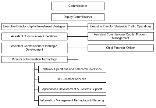
The GIS Unit's work is supplemented by other NJDOT Departments. Collection of spatial data is primarily managed by the Bureau of Transportation Data Development (BTDD) under the Division of Traffic Engineering and Safety (Operations). The BTDD also develops and maintains several databases such as the Digital Roadway Imaging and the Highway Performance Monitoring System (HMPS).
Geospatial Data Accessibility
NJDOT depends on a wide range of sources for its geospatial data. It collects transportation data on state-managed roadways internally through its Bureau of Transportation Data Development (BTDD). BTDD contracts out the data collection on county routes and local streets. Additional roadway information is purchased by the State Office of GIS from Tele Atlas. The Tele Atlas data is then provided statewide to all agencies. As a result of its various data sources NJDOT has data for over 39,000 miles of roadways, including Interstates, toll routes, US routes, state routes, county routes and local streets and ramps. Much of this data is available for download via the NJDOT webpage.
In addition to the data managed internally, NJDOT relies on partnerships with state agencies to fulfill its spatial data needs. Various state agencies and the State's Office of Information Technology work together to collect and fund state enterprise datasets such as orthoimagery, LiDar, and parcel data. In addition, state agencies collaborate through the State Office of GIS (OGIS) to share data with one another and the public. The OGIS maintains NJGIN,59 an internet-based Spatial Data Clearinghouse, which includes downloadable data, dynamic data and maps, and static maps.
Statewide Coordination
In addition to maintaining the spatial data clearinghouse, the OGIS plays a key role in coordinating statewide GIS activities by promoting the use of GIS technology among state agencies and providing statewide leadership in the development of New Jersey's spatial data infrastructure. In addition, the OGIS brings together the GIS coordinators from all state agencies bi-monthly to discuss issues, such as enterprise projects and data sets, and to provide input on statewide GIS policy.
Because of this statewide collaboration, NJDOT decided to convert their GIS software standard from Intergraph MDE to an ESRI ArcGIS platform in order to comply with the statewide standard. Having all state agencies using ESRI products resulted in a cost savings to the state, while at the same time providing a common framework for all GIS users to operate.
Funding
NJDOT's GIS activities enjoy a reliable funding stream via FHWA's SPR Program. Every two years, the BIMTP, with input and approval from NJDOT Executive leadership, requests SPR funding for a list of GIS priority projects. The FHWA Division Office reviews this list and makes suggestions on additional projects and funding. While the two agencies may not always agree with the other's priorities, the collaborative working relationship has lead to the development of valuable GIS activities. For example, the FHWA Division Office has encouraged NJDOT to increase its effort to make GIS data available online for public use.
Key Success Factors and Recommendations
- Integrate geospatial data with existing databases. A future goal for the NJDOT is to integrate geospatial data into the Department's numerous databases in order to make mapping a ubiquitous function. In 2008, NJDOT plans to complete the integration of 8 Transportation Management Systems, which will include spatially enabling the integrated data. NJDOT is also working on a Dashboard to display business metrics. The dashboard information, which will be housed in a Data Warehouse, will be spatially available as well Being able to view data spatially provides a level of analysis that is beneficial to all divisions, whether it be improving asset management or planning transportation projects.
- Draft statewide standards - The drafting of a statewide GIS standard ensures that most state agencies are working off of the same page. This common framework has facilitated collaboration among agencies on GIS activities, including sharing data and applications and developing policy to overcome common problems.
- Secure reliable funding - NJDOT's reliable funding stream has been a critical component in the success of its GIS activities. While lack of funding has been a limiting factor for NJ State agencies that rely on state monies, NJDOT's access to Federal transportation funds to support its GIS activities has enabled the Department to continue to expand and progress its GIS activities.
New Mexico DOT Case Study
Contact: Glenn Condon, (505) 827-5229
glenn.condon@state.nm.us
Background
The New Mexico Department of Transportation's (NMDOT) initial involvement with GIS began in the mid-1980s. At this time the Engineering Design group was just beginning to use Computer Assisted Design (CAD), and one staff member within the Engineering Support Group had a vision of how GIS/GPS technology could also be used. His efforts to champion the use of GIS resulted in the creation of a small, three-person GIS in 1985. While the Engineering Division was interested in GIS, CAD was its main priority. Within a few years of formation the GIS Section was transferred out of Engineering and into the Planning Division.
Business Model for Geospatial Technology Implementation
Organizational Structure
After being located in the Planning Division for a number of years, the GIS Section and similar units were centralized under the Information Technology Division (see Figure 20) in the late 1990s. The GIS Section has a staff of four full-time employees, who are responsible for producing maps, purchasing and maintaining software, managing the department's spatial base map, and conducting spatial analysis. Much of the GIS section's work is customer driven, with requests coming from the Rail, Planning, Right-of-Way, Drainage, Survey and the Environmental Bureau. Due to a lack of staffing, the GIS Section is only able to support the NMDOT District in a limited capacity.
Figure 20. New Mexico Department of Transportation Organization Chart
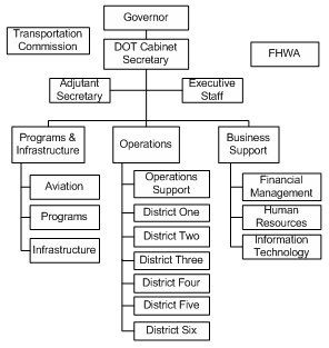
The GIS Section is complemented by a number of NMDOT departments, including the Data Collection Bureau, which collects various planning and engineering data and maintains the Consolidated Highway Database System (CHDB), the aerial photography unit, which scans and manages all imagery for the NMDOT, and the Intelligent Transportation System Group, who is developing a web-based real time mapping application.
Spatial Data Acquisition
NMDOT's original road network was developed by the local University. The road network primarily represents the state road system and federal aid local roads, classified as collector or above. NDMOT collects and maintains data for the state managed roads, and relies upon MPOs and counties for the local road system data.
The state's Division of Local Governments is the lead agency for the state's Enhanced 911 program. As such, the agency has the most up to date road centerline data. NMDOT has been working with the Division of Local Governments for the past 7 years to develop an agreement to share the road centerline information. The main obstacle to establishing the data sharing agreement was the counties' interest in recovering the costs of developing the data. Through extensive negotiation the two agencies recently signed an MOU whereby NMDOT receives the centerline road data in exchange for mile marker data.
Data Accessibility
NMDOT currently has three primary data silos with little synchronization between them. While the databases are isolated, NMDOT staff members generally have access to all data. In addition, NMDOT makes much of its spatial data available to its federal, state and local partners through its FTP site, and a small number of static maps are made available to the public via NMDOT's website.
Future
The Transportation Programs Division is currently developing a Transportation Information Management System (TIMS) to replace the Consolidated Highway Database System, and consolidate its data sources. The TIMS will become NMDOT"s primary information management system, and will include the infrastructure management, traffic, pavement, assets and HPMS data. The TIMS will be tightly integrated with GIS and be web-enabled for easy access to information. The GIS Section has been supporting the Transportation Programs Division with developing TIMS, and at this point, it is unclear which department will be responsible for the spatial functions of the system.
Funding
NMDOT's GIS unit is funded through FHWA SPR funds. The GIS activities have to compete with other planning priorities, and as such, while the unit has a reliable source of funding, the level of funding it receives annually has not been sufficient to meet the needs of operating a successful GIS program.
Challenges
A challenge that NMDOT has faced in developing its GIS program is:
- Coordination of GIS activities - Although the GIS Section is centralized within the IT Division, GIS activities are highly dispersed throughout the agency. Multiple departments, including Planning and ITS, are developing spatial applications. A lack of coordination between the various groups coupled with an undefined division of responsibilities among the departments involved in GIS has resulted in an inefficient use of resources.
Key Success Factors and Recommendations
- Develop spatial applications that meet multiple needs - With the creation of the new Integrated Transportation Information System it is important to design the spatial referencing component in a way that meets the needs of the larger GIS community. Having data that is useful only to the Department of Transportation misses an opportunity for the Department to serve as a geo-spatial data source and advance the use of GIS statewide.
- Create demand for GIS by showcasing its potential
New Hampshire DOT Case Study
Contact: Glenn Davison, (603) 271-7145
gdavison@dot.state.nh.us
Background
The New Hampshire Department of Transportation (NHDOT) started utilizing GIS in the early 1990s when it purchased a dual CAD/GIS package to support highway and bridge design. As GIS technology emerged, NHDOT decided to begin assigning staff to develop GIS layers by digitizing USGS quadrangle maps. Today, NHDOT has a dynamic, high-quality statewide base map, which has provided the foundation to expand the role of GIS within the Department's decision-making process for transportation improvements and project selection.
Business Model for Geospatial Technology Implementation
Organizational Structure
NHDOT's GIS Section is located in the Bureau of Planning and Community Assistance (see Figure 21). At its largest, the GIS Section employed 14 staff members. A restructuring of the Department that occurred in the mid-2000s reduced staffing to eight, where it remains today. The section staff includes a supervisor, four technicians and two application developers and a HPMS program coordinator
Figure 21. New Hampshire Department of Transportation Organization Chart
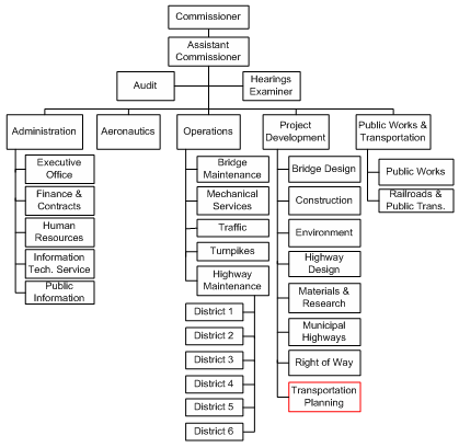
Currently, NHDOT does not have a "GIS Specialist" job classification, but rather GIS staff members are classified as "Engineering Technicians." As a result, the GIS staff members primarily have engineering backgrounds. However, the Department is working on drafting new classifications in order to more accurately address the skills and qualifications necessary to perform GIS functions. With the new classification, NHDOT hopes to attract applicants with a wider range of skill sets.
The GIS Section is responsible for developing transportation related data layers, maintaining the base map, developing GIS applications, providing analysis based on end-user needs, and providing mapping products. Previously, the GIS Section collected and maintained all of the DOT's spatial data, but now NHDOT's Bureaus are each responsible for acquiring and managing the date they use, while the GIS Section continues to maintain the base map. The GIS Section also establishes Department-wide standards and guidelines of how the Bureaus should collect spatial data, facilitating its incorporation into GIS.
Data Availability
NHDOT uses GPS to collect and update existing spatial data on the state maintained road system. In addition, NHDOT has purchased digital aerial orthophotography for the southeastern portion of the state and are developing plans to collect aerial orthophotography statewide. NHDOT also works with the state's Regional Planning Commissions, Metropolitan Planning Organizations (MPO) and towns to collect data for the local road system. The Department relies on these partners to provide updates on the sections of the state road system located in their jurisdictions.
The DOT also collaborates with state agencies through the GIS Advisory Committee, which was established in the late 1980s to coordinate statewide mapping and GIS-related activities. Representatives of all state agencies actively involved in mapping, as well as representatives of several federal agencies, regional planning agencies and the University of New Hampshire, participate in the Advisory Committee. Most recently this group drafted a Statewide GIS Strategic Plan60 to advance the statewide spatial data infrastructure and services. Additionally, NHDOT and other state agencies share spatial data with each other and the public through NH GRANIT,61 the state's GIS clearinghouse.
Funding
NHDOT uses FHWA's SPR program to fund its GIS activities. The average annual budget for the GIS Section is $500-$750,000, as funding requirements vary from year to year depending upon the type of projects undertaken.
Future Efforts
For much of its existence, NHDOT's GIS Section has worked on developing and enhancing the quality and accuracy of the geospatial base map. Now that the base map is in a sustainable format, the GIS Section is focusing on increasing the role of GIS within the asset management policy and decision-making process. This effort is driven by the public's growing demand for a justification of how transportation spending decisions are made; GIS provides NHDOT a means to support decisions through a data driven process. NHDOT is currently undertaking a readiness assessment to compare its existing GIS infrastructure to the Department's goals regarding how it wants GIS to evolve. Based on the results of the assessment, NHDOT will develop an implementation plan to more fully use GIS in its asset management program.
The GIS Section is currently organizing two internal GIS Steering Committees, an Executive/Technical Committee and a GIS Asset/User Committee. The Executive/Technical Committee, which will include Directors and asset management and GIS Leaders, will meet bi-monthly to discuss NHDOT's GIS policies and address technology infrastructure needs and issues. The GIS Asset/User Committee, which will include NHDOT staff who have GIS responsibilities, will meet monthly to share knowledge and practices on how to utilize GIS.
Key Success Factors and Recommendations
- Develop a Sustainable Base Map - An accurate base map with up-to-date data is critical to a robust GIS. NHDOT has invested significant time and resources in updating and sustaining its spatial data base map. With the base map now at a maintenance level, NHDOT's GIS staff will likely be able to devote more time to analysis and system enhancement, expanding GIS' roles within the Department.
- Secure Executive Leaders Support - Even though NHDOT's Executive Leadership team has been open to using GIS as a tool, use of GIS still represents a change to the way staff is accustomed to viewing and manipulating data. As a result, the GIS Section works with its leadership to make them more comfortable with GIS and what it can do. The GIS section is working diligently to cultivate support for the institutional change in the way staff considers spatial information. It is the GIS Section's hope that executive level support will facilitate support from staff department-wide.
- Tailor GIS to End User Needs - While NHDOT's GIS Section has developed a number of GIS tools for its end users, it has sometimes faced difficulty in getting the users to utilize the tools. When developing the applications, the focus should be on how the end user itself plans to use the data - not what others perceive the use to be. The GIS section is working with the GIS Asset/User committee to focus data and application development efforts.
New York DOT Case Study
Contact: Kevin Hunt, (508) 485-7152
khunt@dot.state.ny.us
Background
The New York State Department of Transportation's (NYSDOT) initiated its GIS program in the early 1990s. The GIS program grew out of the existing Mapping Services Bureau, which was responsible for photogrammetric mapping for engineering purposes and updating paper mapping at various scales for the Department's planning projects. Initially, NYSDOT digitized USGS quad maps and reformatted data from its CADD systems to establish a GIS base map. In 1993, GIS and mapping activities were separated from the photogrammetry function and relocated from Design to Information Services. The purpose of this relocation was to more closely link GIS with IT infrastructure and skills and further facilitate GIS development. Around that time, NYSDOT produced a GIS implementation plan62 to standardize its geospatial policies and establish decentralized support through a network of GIS coordinators, significantly increasing the visibility and appeal of GIS across the Department. Now, virtually every NYSDOT program area uses desktop GIS to support varied business needs.
The GIS program has historically received significant backing from upper management. With leadership buy in, GIS activities at the Department have advanced to a stage where an enterprise geospatial data system, which allows multiple users to access information from a variety of business areas, has been developed. Current GIS efforts involve moving towards and/or enhancing technologies that aid "business intelligence," or in other words, providing historical, current, and predictive views of a variety of business operations. Other current efforts involve expanding the base map's data layers and augmenting the Department's geospatial tools for asset management activities.
Business Model for Geospatial Technology Implementation
Organizational StructureNYSDOT has been undergoing reorganization with the goal of better service delivery to facilitate communication of business information among the Department's Bureaus and to the organization's higher-level leadership. In 2007, NYSDOT established a dedicated Chief Information Officer (CIO) position for the first time and created a new Information Technology Division (ITD). Transition to the new ITD is currently underway. Under this framework, the GIS Section will be part of Business Intelligence, a new business unit.63
The primary responsibilities of the GIS Section, which is currently located in the NYSDOT main office, are to support, coordinate, and implement GIS to meet various departmental business needs. The GIS Section has a staff of 5 full-time employees who support 10 - 12 main office GIS coordinators and 11 regional GIS coordinators. GIS staff members are classified as "Mapping Technologists," positions that require extensive background skills/experience in geography, surveying, photogrammetry, and/or computer science. GIS coordinators are generally either IT Specialists or have other titles appropriate for their program area. To facilitate communication between the main office and regional GIS coordinators, the GIS Section oversees biannual, three-day meetings with regional office staff to explore GIS issues and program needs.
Desktop GIS software is currently installed on 1400 desktops across the Department. However, to encourage user autonomy and meet a broader range of users' needs, NYSDOT supports moving to a web-based environment for many GIS applications, which will eventually reduce the need for desktop GIS software. Furthermore, NYSDOT is moving towards utilization of both in-house and consultant participation to support application development.
Data Availability
Throughout the 1990s, NYSDOT had primary responsibility for the state's cartographic program and digital mapping. In 2002, the state's Department of Homeland Security established the New York State Office of Cyber Security and Critical Infrastructure Coordination (NYSOCSCIC) to address the state's "cyber security readiness and critical infrastructure coordination."64 At this time, NYSDOT transferred many of its geospatial responsibilities to the NYSOCSCIC. The Office now hosts the NYS GIS Coordinating Body, a group that manages geographic information within the state, promotes and facilitates geographic data-sharing, use, and development, sets statewide GIS policies and standards, and coordinates the state's GIS data clearinghouse. The GIS Coordinating Body has significantly increased efficiencies for data collection and sharing across the state. With the support of NYSOCSCIC, NYSDOT has been able to focus on using GIS to meet business areas' goals instead of spending time maintaining and developing spatial data.
As part of its mission, the GIS Coordinating Body attempts to remove barriers to implementing geographic information technology to improve the delivery of public services, protect the public and the environment, and enhance the business climate for the benefit of the State, its municipalities, businesses, and citizens. One effort the organization has promoted is the NYS GIS Data Sharing Cooperative, which is a group of over 700 governmental and non-for-profit organizations that have signed Data Sharing Agreements for the purpose of improving access to GIS data among members.65 Some important elements of the Data Sharing Cooperative specify that data creators retain ownership of information and that information must be shared freely (or with minimal cost) with other members of the GIS cooperative. All state agencies must participate in the cooperative; other voluntary cooperative members include local government, academia, non-profits, and tribal governments.
At NYSDOT, geospatial data are accessible to all GIS end users, as well as any cooperating agencies and consultants working on NYSDOT projects (via a password-protected website). Currently, most data are not accessible to the public, although NYSDOT is working to improve public access to its geospatial data through the NYS GIS clearinghouse in the future.
Funding
The salaries of NYSDOT's GIS Section Mapping Technologists are reimbursed through the SPR program 'Statewide GIS Support' project, which has been a reliable funding source. The total budget for the GIS program, including NYSDOT's enterprise software license and application development by consultants, is approximately $350K/year (excluding staff salaries).
NYSDOT has not completed a formal cost-benefit analysis to evaluate its GIS activities. Like many other state DOTs, NYSDOT frames the benefits of GIS in terms of the technology's ability to help significantly improve and/or streamline decision-making processes.
Applications
The GIS Section has primarily focused on applying GIS tools and data to existing business workflows with the goal of improving efficiency and/or quality. Wherever possible, these efforts have been completed without writing custom code that must be supported and maintained. With the support of GIS coordinators, GIS users in most NYSDOT program areas have built GIS projects and applications using the ESRI suite of desktop GIS tools that is the standard NYSDOT geospatial platform. Custom applications, however, have been developed where appropriate. For example, the Capital Project Viewer is an internal map-based tool that allows executives and relevant stakeholders to view information about NYSDOT's Capital Program, projects planned, underway, or recently completed. This application was one of the earlier efforts to make the Department's business information more readily available to the higher levels of the organization.
Several public-facing applications have been developed. The most highly visible application is the Real-Time Transportation Status System,66 which offers a user-friendly interface and the ability to navigate different areas of the state to view information about traffic speed, roadwork, closures, and weather. Initially, NYSDOT considered using an in-house environment to provide base-mapping for this application. Ultimately, NYSDOT decided to enter into an agreement with Google to support this application. In making this agreement, NYSDOT sought to leverage Google Maps API to take advantage of a high-performance, widely-recognized user interface in order to reduce maintenance burdens on the internal environment.
Other GIS-based applications include the Geodetic Control Viewer,67 which allows users to access information related to geodetic survey controls, and the Over Size/Over Weight Vehicle Pre-Screening Tool,68 which helps commercial trucking users identify appropriate travel routes for oversize vehicles by providing information on bridge postings, clearances, and temporary highway restrictions due to construction or maintenance activities.
Future efforts will focus on increasing the GIS Section's involvement with formal needs assessment activities for the Department and project management to improve communication with all business areas. In addition, NYSDOT plans to:
- Work to transfer GIS applications to a server-based environment;
- Increase investment in web-based services to enhance application connectivity; and
- Warehouse departmental information in a publicly-accessible portal, among other things.
To further support enterprise development, NYSDOT anticipates using relevant business intelligence software (e.g., Oracle, Business Objects). This software combines web-based GIS and data-warehousing technologies to provide valuable information not currently readily available and also enables end users to query/analyze data from different data systems.
Challenges
- Maintaining GIS expertise - Although a rare occurrence, GIS staff turnover in the GIS Section or regional offices significantly affects NYSDOT. Because of the diverse functions and applications of GIS in NYSDOT, it takes a full year for new staff to become familiar with their roles. Additionally, it can be difficult to find a replacement GIS coordinator with sufficient GIS expertise to support the broad range of applied GIS that regional offices utilize. During times when regional offices do not have an adequate number of GIS coordinators, technical questions must be re-routed to the main office GIS Section, drawing already limited staff away from their day-to-day responsibilities.
- Strategic Plan - Advancements in GIS technologies necessitate revisiting NYSDOT's original strategic implementation plan dating from the early 1990s. NYSDOT is interested in establishing a modern implementation plan to reassess needs, prioritize GIS implementation efforts, and specifically address ways to promote and market the GIS program, both internally and at the state level. Other state agencies in New York have completed plans that have been effective in garnering high-level support for activities aimed at advancing agencies' missions. A modernized strategic plan could help NYSDOT emphasize the importance of an enterprise GIS to meeting seemingly disparate, yet interrelated, business needs within the Department.
North Dakota DOT Case Study
Contact: Brian Bieber, (701) 328-2649
bbieber@state.nd.us
Background
The North Dakota Department of Transportation's (NDDOT) Planning Division began utilizing GIS as a tool to improve the maintenance of the county base map. In the early 1990s, NDDOT shifted their work methods for maintaining the base map from a pen and ink environment to the digital realm. Once the information was available in an electronic format, staff in a number of NDDOT Divisions saw how GIS could enhance business operations. Use of GIS then expanded beyond the Planning Division. Today, NDDOT has an array of spatially located transportation features and geospatial data is used extensively to inform transportation decisions.
Business Model for Geospatial Technology Implementation
Organizational Structure
GIS responsibilities at NDDOT are divided between two Divisions. The Planning and Programming Division manages the cartography aspects of GIS, creating maps and maintaining vector data related to transportation projects, while the Information Technology Division is responsible for geospatial application development, software and hardware maintenance, and training (see Figure 22). Staff members in both the Planning and IT Divisions provide support to NDDOT's GIS end users.
Figure 22. North Dakota Department of Transportation Organization Chart
NDDOT's GIS end users are spread throughout the Department, including the Design, Photogrammetry, and Environmental Divisions and the District offices. Currently, end users primarily use GIS as a decision-making tool. Visually displaying the base reference supports investment decisions and assists in explaining those decisions to upper management and decision-makers. Due to lack of an expert user base, GIS is used to perform analysis to a lesser extent.
Spatial Data Acquisition
Most departments that utilize GIS are responsible for collecting data in their area of interest. NDDOT is pursuing the option of contracting out some its specific data collection needs, but before it can do so, the Department will need to develop data collection specification and standards. In addition to internally-collected data, NDDOT staff members have access to spatial data through the North Dakota GIS Hub (NDGH),69 the state's GIS data clearinghouse, from state agencies and their partners.
Geospatial Applications
NDDOT has developed a number of small geospatial applications to integrate GIS into everyday workflows. One such application (available internally only) is the Pathway Image Log. Each year, NDDOT drives the entire state highway system and has amassed over six million images. These images are integrated with GIS data and made available to all NDDOT staff via an intranet application. Through this application, any NDDOT staff that has a broadband connection can "drive" any part of the state highway system, locate a point of interest, and view its associated features with a click of a button. This image viewer application was built as a foundation for NDDOT's GIS-enabled enterprise Web portal, called the Online Roadway Analysis and Mapping Portal (On-RAMP). This portal integrates NDDOT's other spatially enabled applications, including the Roadway Inventory Management System (RIMS) tool, and allows for additional functions and data to be added in the future to support a variety of transportation business practices.
In addition to these spatial applications available to internal staff, NDDOT makes a number of interactive and static maps available to the public via its internet site. Available maps include county base maps, traffic maps, Right of Way plots, construction maps and the Transportation Information map.70 In addition, NDDOT contributes much of its data to the statewide GIS clearinghouse, where it is accessed by state agencies, private entities, and the public.
Funding
Since NDDOT's GIS responsibilities are dispersed between multiple Divisions, the funding for GIS activities comes from multiple sources. The Planning Division receives funding from Federal State Planning and Research (SPR) funds, which supports the maintenance of the spatial base data. The IT Division does not have a budget to support GIS activities: the end-user is responsible for funding the services received from the IT staff, (i.e., application development). Similarly, the IT Division has to annually request training funds from NDDOT's training budget. As GIS receives higher visibility throughout the Department, it has become easier to secure funding from departments to invest in GIS-related work.
Obstacles
Some difficulties NDDOT has faced in advancing its GIS activities include:
- Data Sharing - NDDOT's IT Division encourages staff to make the spatial data that they collect and manage available to staff throughout the Department. While data sharing has improved, some departments continue to protect their data due to a perceived notion that sharing the data would diminish their authority.
Key Success Factors and Recommendations
- Secure upper management buy-in - Convincing decision-makers that GIS is a tool to help people perform their jobs better is critical for the success of the GIS program. NDDOT has created a number of spatial applications; however, many staff do not utilize what is available. While NDDOT's GIS staff members continually work on promoting GIS, support from the management level to directly encourage staff utilization of GIS applications would greatly enhance the level of use across the Department.
- Centrally Organize GIS Responsibilities - NDDOT has historically divided the IT and cartographic functions of GIS between two Divisions. Organizing the responsibility for GIS under one group would enhance the progress of GIS and help to keep all activities moving in sync.
Ohio DOT Case Study
Contact: David Blackstone, (614) 466-2594
Dave.Blackstone@dot.state.oh.us
Background
Ohio Department of Transportation (ODOT) was one of the first state DOTs with an operational GIS. ODOT's GIS was initiated in the late 1970s and early 1980s and has evolved from a system allowing users to overlay and display crash data on layers such as pavement conditions and traffic volumes (State Accident Information Reporting System - STAIRS) into a tool supporting many of ODOT's business areas. The importance of GIS in transportation decision-making is increasingly pervasive and recognized within ODOT. ODOT uses GIS in several ways, from aiding in the project selection process to analyzing environmental impacts - a growing use of GIS at ODOT.
Business Model for Geospatial Technology Implementation
Organizational Structure
ODOT is divided into 12 Districts and a Headquarters office (see Figure 23). Each office carries out GIS functions. At ODOT Headquarters, a majority of the GIS activities are carried out by a GIS Support group within the Technical Services office; Technical Services is a branch of the Department's Division of Planning responsible for, among other duties, maintaining the road inventory for HPMS, collecting the gas tax, making traffic counts, and travel demand modeling.
Figure 23. Organization Chart for the Ohio Department of Transportation, June 19, 2007
Adapted from www.dot.state.oh.us/policy/Pages/ODOTTableofOrganization.aspx. Content no longer available.
The GIS Support group, which has approximately 12 people on staff (there are roughly 60 in IT, the group that develops ODOT's GIS data), helps to establish data standards while working to ensure that the Districts' funding and training needs are acknowledged and addressed. The actual "on the ground" GIS work is done at the District level. This decentralized model was put into practice as it became less expensive to have 12 Districts do their own GIS analyses and manage their own individual customer requests.
Although GIS activities are distributed within ODOT, the Districts coordinate closely with the Headquarters office. Specifically, each of the Districts has its own GIS Coordinator who acts as a liaison to ODOT Headquarters and the other Districts. The GIS director at Headquarters uses the District GIS Coordinators as "sounding boards" to assess needs, challenges, and the current state-of-the-practice. Additionally, the GIS Coordinators meet quarterly to share effective practices and lessons learned.
Outsourcing for GIS has only recently become an option that ODOT pursues.
Funding
Early on, monies from the Highway Safety 402 Program, which is a program used to support state and community efforts to reduce deaths and injuries on the highways, funded ODOT's GIS activities. Now, a majority of support for the Department's GIS comes from FHWA's SPR funding. Decisions on where to direct GIS funding are based on requests that the Districts send to the GIS director at ODOT Headquarters. Headquarters then reviews the funding requests to confirm that they are compatible with ODOT policies and that - if funded - the requests would not promote stovepipes within the DOT. Once the budget is set, each office uses the funding as it deems appropriate. It is expected that the current GIS budget of $4-5 million/year will increase as the number of GIS users within ODOT continues to grow.
To date, ODOT has not completed a cost-benefit analysis for GIS. However, ODOT works to bring the wealth of data already collected into its GIS system, further capitalizing on previously funded activities. For example, under its Organizational Performance Index71, ODOT assesses statewide and district maintenance operations, as well as pavement and bridge conditions. When these data are collected, geographic information about where the data measurements occurred are recorded and then included in the GIS. Additionally, in ODOT's view, if GIS analysis helps to avert just one disaster, it has likely paid for itself. For example, Ohio's Department of Natural Resources (DNR) had mapped the location of old, underground mines using USGS maps. Through a partnership agreement, the DNR provided these data to ODOT to develop a risk probability model for road collapses. GIS analysis allowed ODOT to quickly develop this model, potentially averting a costly emergency situation.
Data Sharing and Development with County Partners
GIS relies on dataset consistency, but since Ohio has 88 counties, maintaining data consistency could pose a challenge. In order to address this issue, ODOT has signed an MOU with 30 counties that establishes a process for ODOT to acquire the county roads data, which a county engineer usually is responsible for maintaining. Under the MOU, ODOT provides funding to the county to pay for half of the cost of developing the county roadway network. In return, the counties give ODOT access to their respective datasets. The agreement helps to ensure that Ohio counties are abiding by the same data schema as the DOT, better enabling data consistency. ODOT anticipates signing MOUs with additional counties in the future.
Ohio Statewide Imagery Program
The Ohio Statewide Imagery Program72 (OSIP) is a partnership between State agencies and the federal government to develop high-resolution imagery and elevation data for the entire state of Ohio. The OSIP works to provide a common visual geographic framework that all levels of Ohio government can use, enabling more effective planning and emergency response. The data obtained through OSIP replaces dated 1M black and white digital ortho quarter quad imagery that was developed through a partnership with the USGS in 1998 and the USGS 30M Digital Elevation Model (DEM) with higher resolution data. ODOT, in partnership with other state agencies, pooled funds to fly the state for satellite imagery the last two years. By the end of 2007, the OSIP will have produced 1-foot, color, orthorectified imagery for the entire state, which Ohio DOT will use to update the road network. During imagery acquisition, counties were given the opportunity to request 6-inch data, in addition to the 1-foot data available for free; counties were only asked to pay the difference in cost between the two. Twenty-two counties chose to fund acquisition of the 6-inch imagery. The cost to fly the entire state cost approximately $5 million.
Key Success Factors and Recommendations
- Deemphasize GIS and integrate it into business practice - Some companies developing GIS-related software, such as Google, have raised the bar for what users see as intuitive. At ODOT, GIS technology is still such that GIS-savvy staff are required. Although GIS at ODOT is located within the Division of Planning and its staff is supportive and knowledgeable, in the future more of the GIS responsibilities could be moved towards IT. Nevertheless, ODOT is continuing to try to bring GIS to the lay person in efforts to make GIS "just another tool" that is user friendly, intuitive, and powerful for all users.
- Avoid being data rich and information poor - DOTs sometimes have an abundance of data but do not know how to analyze them. By focusing on what the data are and mean, the GIS tools developed can be shaped to match the data inputs as much as possible and, thus, help conduct the best analyses.
- Consider Three-Dimensional Options - GIS has traditionally been a two-dimensional medium. However, the cost of developing 3-D applications continues decrease while the potential benefits grow. Consider looking into using vendors who have more fully appreciated the 3-D arena and how its products might benefit the transportation community and related stakeholders.
Oregon DOT Case Study
Contacts: Darlene Gowen
Darlene.M.Gowen@odot.state.or.us
Mike Stone
Mike.Stone@odot.state.or.us
Background
Oregon DOT (ODOT) first began using GIS during 1999 and 2000. At the time, ODOT's geospatial activities relied on shapefiles that various federal agencies and other outside sources provided. A significant amount of time was spent converting the information contained in shapefiles into CAD format to aid primarily in project engineering design. Since then, and particularly in the last four years, ODOT has worked to bring geospatial tools into everyday use. Focuses have been on collecting geospatial data from a variety of state, county and local agencies, providing enterprise data to all of ODOT, and building a statewide Oregon transportation network (ORTRANS). The enterprise data is available in ESRI shapefile format and is made available for viewing via a web application called TransGIS. TransGIS is designed for users of every skill level, TransGIS now offers quick access to the many complex data resources, including information on STIP projects and environmental data.
Business Model for Geospatial Technology Implementation
Organizational Structure
The majority of ODOT's GIS activities are coordinated through the "GIS Unit," which is located in the Transportation Data Division (see Figure 24).
Figure 24. Organization Chart for the Oregon Department of Transportation
The GIS Unit, which has a staff of approximately 15 FTE, is responsible for activities such as:
- Map production.
- GIS data (shapefiles) and geospatial application development.
- Geospatial analysis.
- Coordination of geospatial activities in support of statewide emergency response.
Within the unit, approximately five staff members are dedicated to mapping functions, three staff members focus on environmental activities, and three staff members write small-scale applications. Other staff members are dedicated to performing GIS tasks - primarily for planning purposes - in each of ODOT's five regions. In the future, ODOT expects to place a GIS analyst in each of its Regional Technical Centers. These Centers are responsible for ensuring that aspects of projects are delivered within approved scope, schedule, and budget for each region. Historically, GIS staff turnover has not been a problem.
When hiring new GIS staff, ODOT typically does not require a strong IT background, but instead seeks candidates with diverse backgrounds. Some qualifications that job descriptions usually include are a fluent grasp of software such as ArcGIS, CAD, and the Adobe suite, as well as an understanding of how these and other software are leveraged to support transportation decisions.
Funding
ODOT's GIS activities are mostly funded by federal SPR dollars. In the past, the U.S. Geological Survey (USGS) has also provided some funding. During the 2005/2007 biennium (July 1 to June 30), the GIS Unit expended $3.1 million, up from $2.7 million in the 2003/2005 biennium.
Data Collection and Maintenance
Currently, a large portion of ODOT's GIS activities are customer-driven. Customers throughout the Department provide project requests to the GIS Unit. The GIS Unit then works to find, acquire, and/or perform the necessary analysis with the relevant geospatial data. In order to ensure that the GIS Unit can most effectively aid in decision-making, its ODOT customers are increasingly involved in data collection - making an effort to gather geospatial data at every opportunity. For example, the road inventory classification team and the pavement data team each gather geospatial information via GPS as part of their routine duties in the field.
As part of its Asset Management Initiative,73 ODOT has also made it a priority to determine the sectors in which to concentrate data collection and then strengthen the links between GIS and those sectors.
Current data improvement efforts at ODOT include:
- A move from using shapefiles, which provide "snapshots in time" to using real-time data.
- Improving applications' user interfaces to make them more user-friendly and aesthetically pleasing.
- Improving the ease with which Department-wide users can access, analyze, and manipulate geospatial information.
- Continue working with the statewide data coordinator to ensure the consistency of geospatial data that ODOT develops.
Challenges
- ODOT's databases were not initially set up for GIS - The GIS software can only read one attribute from one field. Currently, there may be three or more highways listed in one attribute field in a table. To complicate matters, Oregon highways are identified by state route numbers, US route numbers, and Interstate routes. In some cases there are multiple highways identified by one route number. The individual highways within a route may not have unique highway milepoints. For example, Oregon 140 covers seven Oregon highways and has four locations identified as "mile point one" on the route. GIS staff had to create an Oregon Highway Number attribute as part of the LRS (linear referencing system). This number has teasingly become known as the "secret highway number," because in many cases those in the field - unaware of the meaning and purpose of the Oregon Highway Number - collect data based on route numbers.
- Meeting users' growing expectations for intuitiveness and aesthetics of applications - With applications such as Google Maps flourishing, it has sometimes been difficult to manage the expectations of ODOT's GIS customers. For example, some within ODOT think that the user-friendliness of the TransGIS interface could be improved. Although improvements are planned, changing the current interface requires significant time and funding - resources that are not always readily available.
- Pressure to make data immediately available - Emerging from ODOT's success in creating TransGIS, there is pressure to make data immediately available on the Internet. Since ODOT reviews and verifies geospatial data before publishing it online, the information is not always accessible in "real time". In addition, some staff in the GIS Unit must provide a 'help desk' function to resolve technical questions regarding the Department's GIS applications. Given the number of questions and the limited staff numbers, it is sometimes a challenge to balance 'help-desk' and 'everyday' responsibilities.
Key Success Factors and Recommendations
- Work to ensure data consistency - To ensure data consistency, ODOT emphasizes the importance of having a unique highway numbering system, the ability to store data in one statewide clearinghouse, and the ability to employ a point of contact to manage data at a statewide level. ODOT also recognizes the importance of being part of a statewide data-gathering effort and planning ahead to avoid "trial-by-fire" situations and to ensure that data will be properly stored and analyzed.
- Establish support from a high-level champion - In order to develop department-wide trust in GIS utility, it is important to have not just a champion of geospatial technologies, but a champion who is highly respected within the agency and knowledgeable about how GIS can facilitate staff members' various duties.
Pennsylvania Department of Transportation Case Study
Contact: Frank DeSendi
fdesendi@state.pa.us
Background
The Pennsylvania Department of Transportation's (PennDOT) GIS program began in the mid-1980s as a cartography-centric operation. Following the creation of two separate Five-Year Strategic Plans for GIS, the program has evolved to support the business needs of the entire organization. Historically, PennDOT has emphasized training programs and district-level GIS management to encourage greater user autonomy. Future efforts will include expanding GIS functionalities to bring GIS to new users both inside and outside of the DOT.
Business Model for Geospatial Technology Implementation
The Geographic Information Division is located in the Bureau of Planning and Research (BPR) (see Figure 25). This Division manages PennDOT's entire GIS infrastructure (e.g., mapping, hardware and software maintenance), in addition to IT expertise on a variety of department-wide projects.
Figure 25. Pennsylvania Department of Transportation Organization Chart
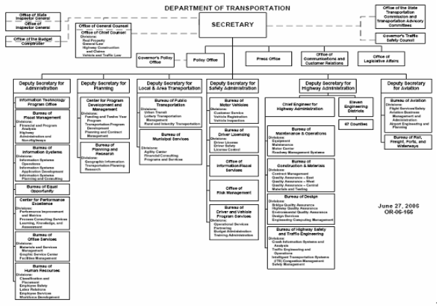
The Division employs 22 full-time staff members. GIS employees are classified as "Transportation Planners," a classification that requires a four-year degree with emphases in math, engineering, and/or geography; there is no specific "GIS Specialist" classification. Additional staff are classified as Information Technologists or Cartographers. When making new hires, PennDOT generally seeks individuals with an aptitude for programming in addition to the requisite educational experience. GIS training is provided to new bureau hires, and BPR coordinates a GIS training program for all of PennDOT.
In addition, PennDOT has 11 District offices distributed across the state's 67 counties. Now, all 11 District offices have GIS operations. Generally, the GIS section in each District employs one lead GIS technician and one GIS coordinator. Overall, the distribution of GIS across counties and districts has helped to increase user autonomy. PennDOT's central office can now devote more time to application development and maintenance and spend less time responding to user queries.
Prior to its current location in the Bureau of Planning and Research, the GIS program at PennDOT's central office was part of the Department's Cartography section. In the mid-1980s, the Cartography section worked to digitize paper maps, but a lack of hardware infrastructure limited the section's ability to support these efforts. In the early 1990s, executive-level support for GIS began to emerge as the Cartography section demonstrated how GIS was an important business tool for the Department. In 1991, PennDOT used staff input, particularly from those working in the Cartography section, to create a Five-Year Strategic Plan.74 The plan, which was intended to provide direction for building a GIS program, addressed how GIS could support PennDOT's business needs, as well as what funding amount(s) and personnel a GIS program would require.75 An executive steering committee comprised of deputy-level staff was responsible for reviewing and approving the plan and designating appropriate vendors to provide GIS hardware and software.
The first Strategic Plan also prioritized the establishment of local (district-level) GIS programs. PennDOT's central office GIS division used a unique process to realize this goal: similar to an RFP, interested districts were asked to demonstrate their plans for GIS implementation. PennDOT then provided GIS software, computers, data, and training to the district deemed to have a superlative plan. Subsequently, after the district implementation was complete, some districts opted to implement GIS in their respective counties to improve district/county communications and planning. Currently, 25 counties have PennDOT-owned machines for their GIS programs.
In 1999, PennDOT published a second Five-Year Strategic Plan to supplement the first. The second plan took a higher-level focus than the first and specified that GIS should evolve from a project-based technology to a tool that could support the broader business needs and mission of the organization. This second plan addressed six objectives for GIS: concentration on PennDOT strategic focus areas, better anticipation of business needs, promotion of partnerships, integration with other information systems, enhancement of data updating capabilities, and strengthening of human resource capacities. The first objective affirmed existing practices and the other five objectives were new or expanded concepts.
Since completing the second strategic plan, PennDOT has made strides towards all six objectives. However, as the GIS system matured, an unexpected management dynamic occurred. The department-wide GIS steering committee lost interest in meeting and guiding progress. As a result, GIS staff have communicated more with PennDOT functional business areas to assess progress, although the second plan's concepts still provide direction for the GIS program and its applications as a business tool. There are currently no plans in place to develop a third strategic plan.
Acquisition of Geospatial Data
PennDOT acquires a significant amount of data it uses from its 12 districts. More specifically, GIS extracts data from PennDOT's legacy systems and inserts these data into an Oracle database for conversion to a spatial format. Data are shared with other entities such as the Pennsylvania Emergency Management Agency (PEMA), Metropolitan and Rural Planning Organizations, and the Pennsylvania Historical and Museum Commission (PHMC), a quasi-remote office of PennDOT. PHMC retrieves data from a PennDOT server and works closely with PennDOT on a variety of data collection efforts.
In addition to data acquired from the district level, PennDOT has provided funding ($100K) to the Pennsylvania Department of Conservation and Natural Resources (DCNR) to acquire orthophotography and Light Detection and Ranging (LiDAR) data. The state has been flown once for orthophotography at a 200' scale with two and then one-foot pixels. DCNR will fly all future orthophotography at one-foot pixels, completing one-third of the state every year.
Data Delivery and Policies
PennDOT's primary GIS customers are the Department's Traffic unit, a group that uses GIS to support their HPMS submittals to FHWA and manage the traffic count program, roadway maintenance, and the Safety Management Division,76 which uses GIS in crash and safety analyses. The ITS/Congestion Management Division is also becoming a major user of GIS.
Initially, there was no governance structure for how internal customers would make requests for the Geographic Information Division's services. Requests usually took place on an informal basis: customers directly approached the PennDOT central office, which then determined what projects to pursue based on the projects' viability, visibility, and alignment with the GIS Strategic Plan and PennDOT strategic focus areas. Over time, however, a governance structure for user requests has been established. Now, all end user requests for GIS system development go through PennDOT's Chief Information Officer (CIO). However, onetime, ad hoc GIS applications and analyses are still informally requested.
Applications
PennDOT's most used GIS application is the Online VideoLog.77 The VideoLog, which was initially developed as part of a Maintenance and Operations pavement survey, displays 20-foot interval photographs of road segments. The Internet version of the VideoLog offers thumbnail images, while an intranet version offers PennDOT staff full-size digital images and additional reporting capabilities. Comprehensive updates to data displayed in the VideoLog occur periodically; National Highway System roads data are updated on an annual basis, while data from all other roads are updated in alternating years.
In addition to the VideoLog, PennDOT maintains the online Internet Traffic Monitoring System (iTMS),78 which displays traffic counts and traffic count information, including truck percent and traffic pattern group. The iTMS allows users to look-up traffic data and traffic monitoring sites by address, zip code, street name, state route number, or intersection. The information is displayed on an interactive map. Commercial developers and engineers are the primary users of the iTMS.
Funding
FHWA's SPR funding supports PennDOT's GIS program. Staff salaries and consultant support services cost for $1.75M annually. Hardware/software purchases and maintenance account for an additional $450K per year.
Benefits
PennDOT has not completed a formal cost-benefit analysis for its GIS program, but explains that the benefits of GIS have been significant both for the DOT and its multiple stakeholders. GIS has increased efficiencies in managing customer requests, facilitated roadway improvement processes, and allowed staff to more effectively respond to roadway safety issues. The VideoLog has also contributed to cost savings across sectors: for example, outside stakeholders such as utility companies have used the application to complete initial project site reviews that would have otherwise required field visits.
Future Activities
PennDOT plans to expand its ability to track users of their GIS applications in order to improve statewide marketing efforts. Organizational change may also occur as GIS is increasingly seen as an IT asset that supports emergency functions and therefore requires constant attention. Funding may be used to relocate the Geographic Information Division to an information services-oriented office and/or a remote location, where round-the-clock staffing and power backup systems can ensure that the GIS will be consistently operational and reliable.
Other plans include expansion of a Road Conditions Reporting System (RCRS), which would enable districts to provide real-time updates to the public, the Bureau of Maintenance and Operations, and/or PEMA about road closures or road conditions during snow, flood, or other emergency events. The expanded RCRS could link to a 511 traveler information network and, in the future, to 911 services. PennDOT has developed a mechanism to export road conditions data to a File Transfer Protocol (FTP) site. An external company then translates the data into voice messages for the public to access anytime via a toll-free telephone number.
Challenges
- Matching and balancing GIS technology with user needs and abilities - It is important to strike a balance between exploring technological capabilities and understanding user needs/requirements. PennDOT is exploring how advanced GIS technologies can best meet the organization's business mission, but it also recognizes that users might not require the most advanced technologies. On the other hand, there may be some GIS users who are 'above the curve' in terms of technological knowledge and may seek support from other DOT divisions if the current GIS applications do not meet their needs or live up to their expectations.
- Meeting the expectations of SAFETEA-LU legislation - PennDOT currently maintains linear referencing for 40,000 miles of state-owned roadways. The remaining 80,000 miles of locally-owned roadways are digitized but do not have a linear referencing network. Therefore, a network must be created and a maintenance plan put in place to meet the safety analysis requirements for all public roads.
Key Success Factors and Recommendations
- Reduce dependencies - Having experienced in-house staff, or staff capable of learning, reduces dependencies on outside consultants and is an important factor contributing to GIS program maturity. In fact, PennDOT requires consultants to work on-site. This requirement provides staff an opportunity to learn new technical skills and improve skills in GIS analyses, application development, web design, programming, and geospatial database development. In addition, the requirement allows PennDOT to diminish its reliance on consultants while developing internal staff capabilities. Finally, PennDOT can more easily monitor consultants' work and foster a team environment where consultants work side-by-side with PennDOT staff. Moreover, the on-site requirement provides significant cost-savings benefits to the Department and represents a more sustainable method of program support (as opposed to flying consultants in periodically to work on an ad hoc basis).
- Utilize Marketing Opportunities - PennDOT emphasizes the importance of utilizing all marketing opportunities to demonstrate GIS program capabilities. Whenever possible, PennDOT attends meetings/events (e.g., the annual District IT coordinator meetings) to showcase the GIS program. Marketing, however, does not always have to involve face-to-face presentations. For example, PennDOT's first Strategic Plan included a white paper documenting '10 Steps to Implementing GIS,'79 one of which was to develop a business logo for the GIS office. The logo has helped to significantly increase the visibility of PennDOT's GIS deliverables both within and outside of the Department and thus has been an important marketing tool.
South Dakota DOT Case Study
Contact: Terry Erickson
Terry.Erickson@state.sd.us
Background
The South Dakota Department of Transportation (SDDOT) began building a GIS program in the mid-1990s. During that time, SDDOT relied upon two platforms (ESRI and Intergraph) to support geospatial data digitization. ESRI software was chosen primarily to maintain and utilize GPS road track data collection of the non-state trunk roadway inventory, which includes information for all public roads not owned and maintained by the state (e.g., county roads, city parks, etc.). Intergraph software was used to digitize 'static' paper maps, support upper management decision-making, and locate highway geometrics. SDDOT's utilization of two platforms developed as an ad hoc strategy to meet departmental needs. DOT management determined that Intergraph's MGE, which was based on CADD technology, could best support maintenance of the Department's automated needs book. This decision was partially vendor-driven (as SDDOT required a custom MGE application) and partially driven by limitations in the representation tools that ESRI software delivered at that time.
Establishing data standards between the two platforms proved difficult and at times compromised communication between Intergraph and ESRI users. In 1996, South Dakota's state government went through a significant reorganization process due to an administration change. As a result, all IT support staff at the agency level were reassigned to a newly-created agency, the Bureau of Information and Telecommunications (BIT). BIT emphasized the need for department-wide standards for GIS activities, which included GIS software. At approximately the same time, high-level support turned to ESRI to meet the organization's business needs for developing a dynamic segmentation process, which involves "reading" a geometrics table to define road segmentation and identification marks. Over time, the Department's GIS use evolved to an ESRI platform and all application and databases migrated to ESRI software.
Current SDDOT GIS efforts involve migrating to a web-based environment for all GIS applications. In addition, work to maintain and/or enhance recently-built applications is ongoing. Due to funding constraints and limited availability of IT resources, future GIS work may involve projects with a smaller, more focused scope (e.g., digitizing borrow pit/gravel source data, which are now displayed on paper maps).
Business Model for Geospatial Technology Implementation
Organizational Structure
The GIS unit is located in the Office of Transportation Inventory Management, which is part of the Division of Planning and Engineering (see Figure 26). The unit has 5 staff. Classifications include 'Mapping Specialist,' 'Transportation Specialist (I and II),' and 'Transportation Analyst.' Staff educational backgrounds and technical skills vary.
The unit's primary responsibilities are to create and maintain geospatial data, maintain the route network, promote the use of GIS across the DOT, train users, and meet customers' business needs through custom application development. Training is made available from ESRI-certified training instructors and staff to support SDDOT's needs.
Figure 26. South Dakota Department of Transportation Organization Chart
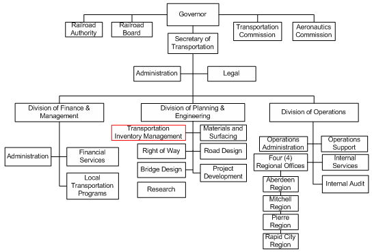
Data Collection, Delivery, and Policies
As early as 1978, South Dakota began to develop a state-level GIS system that was based on remote sensing and analysis of Landsat imagery. GIS in the state gathered momentum over the next 10-15 years and in 1993, SDDOT participated in an informal peer exchange with the Nebraska DOT to assess GIS state-of-the-practice and learn how GIS could meet SDDOT's business needs. The Nebraska exchange increased SDDOT's management support for GIS, which propelled SDDOT to expand efforts to build its own GIS program. Now, GIS products and applications are used to more effectively manage the Department's resources, improve departmental productivity and support policy- and decision-making (e.g., a GIS application may be used to assess whether a section of highway is a candidate for construction, reconstruction, or resurfacing work).
Currently, collecting highway geometrics and other administrative attributes are performed in-house on the state trunk highway system. SDDOT contracts with 4 planning districts, or Councils of Local Governments, to collect data on the non-state trunk highway system (i.e., local roads) on an annual basis. Geospatial data are also acquired from the Farm Service Administration's (FSA) 2-meter aerial imagery. FSA flyovers for the entire state have occurred every year since 2004. In addition, local governments and cities periodically conduct flyovers of their respective locales and SDDOT has obtained some aerial imagery from these entities. Communication between tribal and state governments regarding geospatial data helps to facilitate GIS programs and data-sharing at all levels across the state.
The Department's main data repository for the state trunk highway system is contained in the RES (Roadway Environment Subsystem) database. The Department also utilizes a Pathways Van (VideoLog) that also collects profile and rut data. In addition, SDDOT maintain a pavement management system that helps the DOT evaluate and monitor existing road conditions.
SDDOT uses a pooled-licensing scheme to make ArcGIS available on every computer desktop. This scheme has increased the visibility of GIS across the Department. In addition, SDDOT maintains an open-access policy for data so both internal and external users can access the most current information.
There are several levels of GIS project and resources review at SDDOT. First, through executive proclamation, a cabinet-level GIS Steering Committee was developed to determine the future of the state's use of GIS technologies. A leadership team comprised of IT and departmental GIS contacts also meets regularly to support decision-making about data policies, technology upgrades, and other issues that directly impact the state GIS community. In addition, the Technical Advisory Group (TAG), which is comprised of state, local and private sector representatives, meets on a regular basis to share experiences and knowledge. Finally, potential projects that utilize IT resources must be approved by the Portfolio Management Team (PMT). The PMT reviews these projects to determine whether the project merit, meets the current and future departmental business requirements. Projects are prioritized based on available resources.
Funding
Federal and state funds are used to support SDDOT's GIS program.
Challenges
SDDOT has faced a number of challenges in growing its GIS program. The ability to secure funding for new, custom-built, business-oriented applications is always uncertain. GIS awareness within the Department is expanding, although finding time for adequate training is difficult. It is likely that, once adequately trained, end users will see the potential power of GIS and find ways to incorporate the technology to support their work. To improve educational outreach efforts, SDDOT has, for example, worked with an IT consultant to create user-friendly application interfaces. Such intuitive interfaces encourage user autonomy and increase the visibility of GIS as a helpful business tool.
Key Success Factors and Recommendations
- Prepare a GIS Strategic Plan - A GIS strategic plan can set enterprise data standards and clearly identify how GIS can contribute to the DOT's business needs and mission. With the assistance of GeoDecisions, Inc., SDOT prepared a strategic plan in 2001/2002. Over the past several years, the plan has significantly helped establish a direction for GIS activities, codify GIS program needs, and provide focus for future program efforts. In addition, the plan has increased the visibility of GIS throughout the Department, facilitating efforts to standardize data-collection methods.
- Proceed Incrementally - When building a GIS program, taking incremental steps helps ensure that new technologies, systems, or procedures do not overwhelm or confuse users. It is also important to demonstrate early in the process how GIS can meet users' needs, perhaps through visual displays or maps that can quantify the cost-savings of geospatial technologies. Finally, building a GIS in small, incremental steps will help encourage continued high-level support for the program.
Tennessee DOT Case Study
Contact: Kim McDonough, (615) 741-4037
Kim.McDonough@state.tn.us
Background
The development and implementation of geospatial technology at the Tennessee Department of Transportation (TDOT) has evolved since the early 1990s. Early on, TDOT's GIS system consisted of a series of stand-alone applications, many of them PC-based and used primarily for transportation engineering and design. In 1998, TDOT's Executive Leadership Team, an 18 member group composed of upper management from each of TDOT's Divisions, approved an implementation plan to expand the use of GIS beyond a project-based function into a more process-oriented program. A GIS support group was created under the purview of the Information Technology Office, and one of this group's earliest priorities was to conduct a Functional Requirement Study to assess the GIS needs across the agency. The results of this study now serve to guide the design and development of the enterprise-wide GIS.
Business Model for Geospatial Technology Implementation
Organizational Structure
Currently, two independent TDOT units perform GIS functions, the GIS Mapping and Facilities Unit (Mapping Unit) and the Geographic Information System Unit (GIS Unit) (see Figure 27). The Mapping Unit, the larger of the two units with a full time staff of roughly 18-27, resides within the Long-Range Planning Division and is responsible for the collection of roadway inventory data on interstates, state highways, and local roads, and the preparation of maps, including city, county, traffic and classification maps. The GIS Unit, which is within the Information Technology Division, is responsible for GIS and database design and maintenance. The Unit also works to support other TDOT GIS activities such as:
- Identifying the Department's GIS capabilities requirements
- Determining data needs and data standards; and
- Coordination of data sharing opportunities within the Department.
Figure 27. Organization Chart for the Tennessee Department of Transportation (Adapted from https://www.tn.gov/tdot/about/tdot-organizational-charts.html)
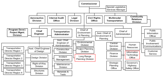
Funding
The State of Tennessee has a comprehensive technology planning process to enhance technology project initiation, review and approval. Each agency is required to prepare an annual Information Systems Plan (ISP), which identifies the agency's prioritized list of information technology projects for a three-year planning period, including descriptions of the objectives, costs and benefits for each project. The ISP in reviewed and internally approved by the agency's Management Advisory Committee (MAC), a senior business management group that directs information technology and participates in the planning and project management process. The individual agency ISPs are reviewed by the Information Systems Council (ISC), an executive steering committee charged with overseeing information technology for the State. The ISC prioritizes and ranks all project requests and creates a Statewide Information Systems Plan.
Within TDOT the Mapping Unit and the GIS Unit are funded separately. The Mapping Unit is funded through federal State Planning and Research (SPR) funds, while the GIS Unit is funded through the State's Highway Funds, the portion of the state's budget funded through dedicated highway user taxes and federal transportation funds. At times, the inherent tension created by the two units' different funding structures has made coordination difficult. Because neither GIS is functionally linked within the organization (TDOT) coordination only occurs as the result of a very deliberate effort on the part of both. Coordination is not inherent within the organizational makeup of Mapping and GIS nor are there any established policies or charters linking the two. In the future, TDOT anticipates a gradual merging of some, but not all, of the Mapping Unit's GIS activities with those of the IT Division's GIS Unit.
Executive support for GIS within TDOT and the State has historically been excellent. As a result GIS is given the same ranking as all other programs within IT. This support has been critical in securing continual funding for GIS projects and programs.
Applications and Data Sharing
TDOT utilizes GIS to fulfill a variety of agency goals and is committed to incorporating a geospatial component in all future systems development, where relevant. Currently, GIS is one of the four technologies employed to implement the Program Development Process (see Figure 28), TDOT's agency-wide effort to reduce the average project development process from 12 to 5 years. This process relies on GIS, Document Management, CADD, and the internet to support the development and use of numerous information systems.
Figure 28. TDOT Program Development Process (Adapted from TDOT's GIS Strategic Plan)
TDOT's most prominent GIS application - having approximately 2000 clients agency-wide - is the Tennessee Roadway Information Management System (TRIMS). TRIMS, a PowerBuilder application that accesses TDOT's Oracle database, enables TDOT to capture, maintain, and view critical roadway data, including traffic, bridges, crashes, railroad grade crossings, and pavement conditions. TRIMS is principally a reporting tool with only about ten percent of TDOT staff using the GIS functionality. TRIMS also provides an integrated interface to TDOT's photologs, which are digital roadway photographs taken of all interstates and state routes. The GIS component provides a query and view interface where roadway data is displayed in a graphical format on a Tennessee state map. From the map, users are able to identify key features and view pertinent data, photologs, and documents to which the feature is associated. The Mapping Unit administers TRIMS' data management internally, but contracts out the majority of the necessary application development and maintenance. Additional data in TRIMS as well as other GIS applications is received from counterpart state agencies, such as the Department of Environment and Conservation, Department of Safety, and the federal government. Aside from data acquired with stated restrictions (e.g. endangered species), all geospatial data is available to those within TDOT and to others by request.
TDOT is currently developing a Statewide Environmental Management System (SEMS) to further enhance the program development process. The development and implementation of SEMS is expected to enable:
- Linking the long range planning process with the project development process;
- Creation of streamlined approaches to involving regulatory agencies, the public, and other interested stakeholders earlier and throughout the project development process; and,
- Ensuring that environmental and other project-related commitments are documented and ultimately fulfilled as part of the project.
Statewide GIS Activities
The Tennessee Base Mapping Program is an important statewide GIS initiative in Tennessee. Managed by the Office of Information Resources GIS Division (OIR-GIS), the program is completing the development of a comprehensive source of GIS data in a common coordinate system for the entire state (Base Mapping Program).80 Data developed as a part of the base mapping program will be accessible to the public and State agencies via the Tennessee Map (TNMap),81 a web portal that serves as the program's data access mechanism. Initial statewide data production efforts were completed in fall 2007, and the next step in the program is developing a maintenance program for the statewide digital orthophotography data layer. Tennessee's Department of Finance and Administration, OIR-GIS, and TDOT have agreed to coordinate their respective mapping efforts to develop this program. TDOT has primary responsibility for project management, ortho photo production, and data delivery, while OIR-GIS Services is responsible for distributing the data and TNMap. In spring 2008, TDOT will begin to collect 1-foot digital color orthoimagery for counties in western Tennessee. It will continue to obtain this imagery for one fourth of the state every year to provide a constantly updated reference layer for the Tennessee Base Map.
GIS Software Standards
TDOT has historically used Intergraph Corporation's CAD technology for its transportation engineering and design activities. As TDOT migrated towards more GIS oriented applications, it was natural for TDOT to begin implementing Intergraph's GIS solutions because of the existing working relationship. However, the State of Tennessee chose GIS software products developed by the Environmental Systems Research Institute, Inc (ESRI) as the statewide GIS software standard. The disparity between TDOT and statewide GIS platforms can cause data standards conflicts, impacting TDOT's ability to integrate its data with data developed by other state agencies. An ongoing issue for TDOT is complying with statewide GIS proprietary standards while at the same time maintaining the flexibility needed to meet its transportation focused needs.
Key Success Factors and Recommendations
- Establish open, interagency relationships - A number of Tennessee's State agencies are utilizing GIS throughout the decision-making process. Developing strong working relationships and data sharing capabilities amongst the various agency's GIS Departments can lead to a more efficient and effective utilization of GIS capabilities throughout the state.
- Work to ensure that business processes are reengineered as technology evolves - As TDOT upgrades and develops new business applications each will be evaluated for its ability to incorporate a geospatial component. However, TDOT should be cognizant of the technology's ability to produce productivity gains.
- Avoid being tied to a proprietary standard - TDOT has a variety of GIS components including input, maintenance, analysis and dissemination. Retaining the flexibility to use a variety of GIS software would allow the different divisions and offices in TDOT to choose the most appropriate software capabilities to meet their unique GIS requirements and needs.
Utah DOT Case Study
Contact: Craig Hancock
Chancock@utah.gov
Background
The Utah Department of Transportation (UDOT) has been working with GIS since the 1970s. However, until recently, the GIS activities were fragmented and ad hoc, undertaken as staff felt a need for it, but not planned or centralized across the department. In 2005, the State of Utah created the Information Technology Services. Within this agency, the Automated Geographic Reference Center (AGRC) facilitates the implementation of an enterprise approach to GIS across the state government. When this agency was created, UDOT's GIS activities were located in the IT unit. Most of UDOT's IT staff members transferred to the AGCR. However, the GIS staff remained with UDOT and relocated to the Project Development Division.
AGRC continues to manage GIS data and applications within the state government. UDOT and other government agencies (federal, state, local, and tribal) compose an Advisory Committee within AGRC. This committee recommends policy and standards, encourages GIS use and education, and promotes data collection, integration, and dissemination among all GIS users.
Business Model for Geospatial Technology Implementation
Organizational Structure
UDOT's GIS unit is located in the Project Development Division (see Figure 29).
Figure 29. Utah Department of Transportation Organization Chart
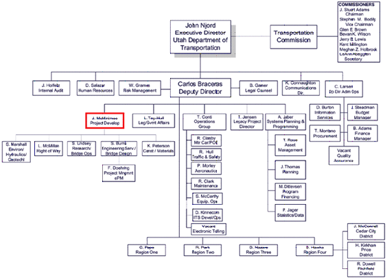
UDOT does not have a job classification that refers specifically to GIS skills. However, the GIS unit has been able to hire people with these skills-engineers, planners, geographers, or IT professionals with on-the-job GIS experience. AGRC occasionally provides training to GIS staff.
In the mid-1990s, UDOT conducted a study to understand the resources and business practices that would be necessary to expand its GIS work. Since then, however, there has not been any is business or strategic plan guiding GIS development. UDOT is currently working with the AGRC Advisory Committee to develop a strategic plan for GIS services statewide. While there are currently no plans for restructuring GIS services in UDOT, the AGRC Strategic Plan could lead to reorganization.
Geospatial Data Acquisition
AGRC maintains a central data repository for the various Federal, State, and local government agencies that use GIS. AGRC's State Geographic Inventory Database contains data in 25 thematic categories and over 350 layers. Historically, UDOT's efforts to collect and compile these data have been fragmented. With the implantation of the statewide GIS database, data compilation has become more systematic. Some of UDOT's geospatial data comes from the AGRC and other state agencies. Local governments share their data with the AGRC, which then provides it to UDOT. UDOT is just beginning to collect its own data and begin to populate its LRS.
Data Delivery and Policies In accordance with AGRC policy, most of UDOT's data is freely available. Some sensitive information - mostly security-related - is redacted.
There is no formal mechanism for requesting UDOT GIS services. Services are provided on an "as needed" basis based on informal communication between other UDOT units and the GIS unit. When customers request desktop access to GIS, the GIS unit purchases a software license for the user.
Funding
The GIS unit has reliable funding. Software is usually purchased using money from the UDOT unit that will be using it or money from the State Information Technology Service.
Benefits
There is a general sense among UDOT's GIS staff and system users that GIS has made important contributions to Department projects and activities. However, there has not been any formal effort to quantify these contributions.
Challenges
Some obstacles that UDOT has encountered while growing its GIS program include:
- Business needs and their GIS components - One of UDOT's biggest challenges is that Department's business needs and GIS capabilities have not been jointly assessed to understand how GIS can be helpful in meeting the business needs. Without a clear understanding and demonstration of the benefits of GIS to the department's core functions, management and others in the department have been reluctant to promote GIS. To address this, the GIS unit conducted a survey and held a workshop to understand the needs of the Department's functions and to demonstrate how GIS can be used to address these needs.
- Benefits of GIS - The GIS unit and others within the Department have a general sense that GIS has made important contributions to some projects. However, there has not been any specific effort to quantify these benefits. Specific, quantifiable analyses of GIS benefits would promote GIS adoption across the agency. However, quantifying the benefits and costs of GIS is complicated and expensive and it outside the scope of the GIS unit's current resources and capabilities.
- Strategic planning for GIS - UDOT has not developed a strategic plan for its GIS activities to guide investment decisions. In the absence of clearly defined goals and strategies, GIS growth within the Department has been haphazard. GIS activities have generally been narrowly focused on specific projects, rather than addressing Department-wide needs. UDOT is in the process of working with AGRC to develop a strategic plan.
Key Success Factors and Recommendations
- Keep an open mind - Since the ultimate goal of GIS is to help UDOT better meet is mandates, it is important for the GIS unit to work with colleagues across the Department to understand their needs and encourage GIS components to meeting these needs. An important part of this is to keep an open mind regarding how to use and grow GIS. Decisions on the future of GIS must be made based on how to help the department meets its needs rather than growing GIS for the sake of having more GIS capability that may or may not be useful across the department. The GIS staff at UDOT encourages requests and feedback from its customers and helps other UDOT units develop their own GIS components when necessary.
- Disseminate information on benefits of GIS - To address UDOT's general need for better quantifiable evidence on the benefits of GIS, FHWA could sponsor studies or compile and disseminate information on how to quantify GIS.
Vermont Agency of Transportation Case Study
Contact: Johnathan Croft
Jonathan.Croft@state.vt.us
Shawn Nailor
Shawn.Nailor@state.vt.us
Background
In the early 1980s before modern GIS was common, cartographers at the Vermont Agency of Transportation (VTrans) created road and town maps using a CADD environment. By the time VTrans had used that technology to develop a digital route log system (mid- to late-80s), a formalized Mapping Unit had been established. This group, which maintains the official record of all public roadways in the state, began exploring various vendors' GIS software during the early 1990s, eventually establishing a licensing agreement with ESRI. It was after this time that GIS activities at VTrans started to grow and flourish. Now, a GIS presence permeates every level of the organization.
Business Model for Geospatial Technology Implementation
Organizational Structure
Currently, GIS functions at VTrans are distributed between two divisions: the Policy and Planning Division and the Information Technology (IT) Division (see Figure 30).
Figure 30. Vermont Agency of Transportation Organization Chart
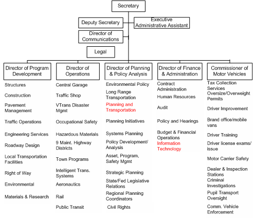
On the Policy and Planning Division side, there is a Mapping Unit that is comprised of three GIS specialists. The unit maintains the official record of all public roadways in the state, which includes the processing of Certificates of Highway Mileage; production of county, statewide, and other special use maps; and the upkeep of the Official Town Highway Maps.
The latter responsibility requires a significant amount of the Mapping Unit's effort. There are 319 town highway maps for Vermont82, each generated in response to requirements outlined in the Vermont State Statutes.83 As the Mapping Unit has described:The maps and the information they contain are closely related to another product of the Agency, the Certificate of Highway Mileage... By early January of each year, the Mapping Unit generates and mails a certificate for each town, city, village, unorganized town, and gore in the state. The mileage numbers contained in the certificate are the mileages on file with the Agency from the previous year's certificate... The town can report that either no changes occurred, or it can record on the certificate what changes occurred and include with the certificate supporting documentation describing the changes.84
When municipalities submit changes to the town road system, VTrans field staff inventories, measures, and verifies the changes, helping the GIS staff to make the necessary changes to the town highway maps and related road centerline data (~15,000 miles). It is estimated that each year, 60-75 towns make changes to their town highway maps. Due to the volume of work these updates constitute, the effects of staffing cutbacks on the Mapping Unit have been especially acute.
The Mapping Unit also maintains straight line diagram route logs for all the highways eligible for federal aid. In the past, the route logs, which are updated annually with all the construction and resurfacing completed in the previous year, were maintained within a CADD system but are now updated within a GIS-based Route Log System.85 The system allows users to specify roadway sections and display attribute data (such as pavement condition, traffic volumes, speed zones etc.). Eventually, information such as bridge inspection photos will be linked to the system.
In the IT unit, two VTrans staff members provide GIS support for the agency, including management of the GIS environment on a centralized server and the desktop environments for VTrans' 1300 staff members, as well as maintenance of GIS software, web-mapping development, and general database administration. The unit has also provided one-on-one GIS training to approximately 200 users (who are served ArcView from the central server) - ranging from the casual user to those performing advanced analyses. As a result of the success of the training, trainees continue to be a mix of staff from business areas across the entire Agency.
Data Availability
Sharing of geospatial data among both VTrans' divisions and among Vermont state agencies is widespread. At VTrans, Operations staff collect on-the-ground data for a variety of business areas in the Agency - information that later populates the GIS and is available to all in the Agency. At the state level, VTrans supplies and acquires geospatial data from the Vermont Center for Geographic Information (VCGI), a public non-profit chartered by the State of Vermont to serve as a data repository for the entire state. Many state agencies supplement the VGIC's geospatial data by linking their databases to VGIC for distribution.
Some current data gaps that VTrans anticipates addressing include:
- More consistent maintenance of the geospatial data available for public transit;
- Advocacy of improved standardization of data attribution across state agencies.
Funding
Since VTrans' primary GIS functions are carried out in two divisions, GIS funding for the divisions comes from different sources. FHWA's SPR funds support GIS activities in the in the Policy and Planning Division. The annual budget is approximately $500k. The IT Division's GIS charge, which includes handling licensing and hardware/software needs, is funded by FHWA at roughly $400k annually.
VTrans has plans to acquire orthophotography for the entire state. It is expected that additional funding will be required during the year that this imagery is obtained.
Obstacles to Implementing the GIS Program
Although VTrans is generally satisfied with how its GIS program has evolved, the maturing process has not been without obstacles. Some of the challenges faced have been:
- Limited staffing - GIS staff in both the planning and IT divisions are often overwhelmed. Adding a full time employee to each would likely ease the workload on existing staff, as well as avoid having to hire temporary staff who need a lot of oversight and are not able to develop a sense of long-term stewardship to GIS and/or the Agency.
- Occasional failure to market GIS internally - In the past, VTrans' GIS staff have sometimes not effectively communicated to others in the Agency all of the remarkable things that are possible using GIS. By shifting to a data maintenance and improvement mode before bringing end users fully up to speed on what GIS does, the inertia of widespread and high-level support can be compromised. As part of its plans to migrate towards a GIS server environment, VTrans intends to first market the concept internally to identify user needs. It is hoped that this will ensure that benefits of new systems are maximized.
Virginia DOT Case Study
Contact: Melanie Seigler
Melanie.Siegler@vdot.virginia.gov
Background
The Virginia Department of Transportation (VDOT) began investigating how GIS could contribute to meeting the organization's business mission in the late 1980s. Over the next 10-15 years, VDOT expanded its efforts to collect geospatial information. At the same time, high-level support focused on developing and implementing an enterprise GIS application to streamline the environmental review process. In 1998, VDOT developed an initial enterprise geodatabase, the GIS Integrator.86 The GIS Integrator is an enterprise spatial data warehouse that is the Department's major repository for viewing, reporting, documenting, and analyzing geospatial information. The GIS Integrator went into production in 2001; since then, the GIS Program has utilized the GIS Integrator framework to develop several applications such as the Comprehensive Environmental Data and Reporting System (CEDAR) and the Online Transportation Information Map (OTIM). Currently, VDOT is moving to a more service-oriented architecture in order to provide comprehensive web-based access to GIS tools and easier application development by non-GIS coders.
Business Model for Geospatial Technology Implementation
Organizational Structure
The GIS unit is located in the Information Technology Division (ITD) (see Figure 31). The GIS program's primary responsibilities are to manage enterprise spatial data and develop GIS applications. The GIS program also supports users by setting data and metadata standards, responding to user queries and requests, and providing GIS data services for other DOT business areas that collect their own geospatial information. The GIS unit also provides training on use of GIS and the associated web-based GIS Integrator portal. Primary internal users of enterprise GIS data include the Traffic Engineering Division, Environmental Division, and the Permits office.
GIS program staff members are grouped into the Application Development and Support, Data Management, and Project Management teams. These groups are comprised of both in-house consultants and state employees. Staff backgrounds are diverse, although most individuals have IT training, and have training in environmental science, geography, and/or geology. Staff size has remained constant because it is difficult for VDOT to fund new positions. Historically, it has not been difficult to find funding to replace staff members who leave. However, finding competitive candidates to hire for replacement positions has been challenging because there are a limited number of qualified candidates in the marketplace with experience managing large, enterprise GIS systems.
Figure 31. Virginia Department of Transportation Organization Chart, December 17, 2007
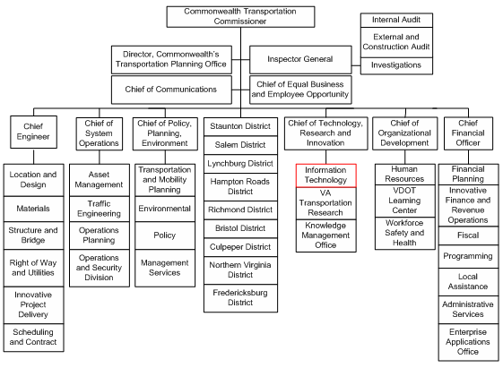
Data Delivery and Policies
As part of an Asset Management Division project, VDOT drove the state roads with a GPS unit in 1999 and 2000 to collect road centerlines. When that project was completed, the GIS unit began to maintain the road centerlines.
In early 2001, the state's Geographic Information Network (VGIN) used aerial imagery to re-digitize the road data for use in E-911 addressing and public safety. VDOT and local governments now work with VGIN to keep enterprise centerlines up-to-date. The centerline and other metadata are available on the VGIN metadata portal/clearinghouse,87 which is available to the public on a limited basis and to registered users on an expanded basis. All state agencies are required to report geospatial metadata to VGIN on a quarterly basis for inclusion in the portal.
VDOT's GIS Integrator also houses data from other state agencies, including the state Departments of Environmental Quality, Game and Inland Fisheries, and Conservation and Recreation for use in CEDAR and other enterprise applications. Currently, the GIS Integrator contains over 150 data layers, which are reviewed and updated on a mutually agreeable schedule with the source agency, although sensitive information is redacted from publicly-available data sets. All requests for new applications or new data layer development go through a process of approval. While the project approval process is undergoing some changes/updates, it involves an internal approval of small-scope (under $100K) projects and approval from the state IT agency for larger (over $100K) projects.
VDOT purchases some datasets, such as road data for routing purposes, and has considered purchasing other sets (e.g., parcel data) as a future option. Outside of the GIS program, several DOT business areas (such as the Transportation and Mobility Planning Division and Northern Virginia District) manage their own data and have developed customized GIS applications. The ITD manages the central network and maintains specific enterprise environmental/roadway data layers on behalf of various federal and state agencies, which may not have the IT capacity necessary to do their own maintenance work.
VDOT divides the state into 9 district offices, over 45 residencies, and over 250 area headquarter field offices. Recently, VDOT completed a study to examine options for consolidating area headquarter offices to allow more focus for office activities. Both field and district offices provide data to VDOT for use in the Comprehensive Environmental Data and Reporting (CEDAR) application, which catalogues transportation and natural resource information to contribute to environmental decision-making.
Future efforts will focus on building the enterprise system around a service-oriented architecture and moving from a current model of separately-developed GIS applications to a system that supports web-based access to GIS tools and data. This move is supported department-wide as other internal divisions expand their GIS systems. VDOT notes that this move represents a significant technological change, since providing GIS access to a broader community of users will involve heavier utilization of web-based systems that do not require specialized coding knowledge.
Funding
VDOT receives funding from various state taxes (e.g., the gas tax). The GIS Program has also used federal SPR grant funds to fund specific projects.
Challenges
- Need for Staff Augmentation - The ITD office does not have sufficient full-time GIS staff to address all user requests and needs; there is an ongoing need to augment staff. Consultants have helped to supplement staff skills on an ad hoc basis, but VDOT's consultants are generally self-employed and do not receive benefits. Rapid consultant turnover has made it difficult for VDOT to grow the GIS program at a sustained long-term level.
Key Success Factors and Recommendations
- Proceed Incrementally - It is important to take incremental steps when building a GIS program to ensure that new applications, systems, or processes do not overwhelm or confuse users. For example, VDOT added only 8 data layers to the first iteration of the GIS Integrator in 2001 and slowly added more layers over time. This incremental process allowed VDOT to establish a quality GIS program and set a precedent for data maintenance, documentation, and response to user requests. As a result, department-wide trust in GIS has increased.
- Mainstreaming - Thoroughly understanding users' needs and expectations will help DOTs to more efficiently build GIS applications. The relatively recent development of Google maps and other web-based mapping programs has raised the general user population's expectations regarding geospatial technologies. While managing the expectations of those who use and view products like Google maps, it has been difficult for GIS experts at VDOT to communicate GIS functionalities to non-experts in the public or federal arena. To improve lines of communication, DOTs should consider ways to make GIS application interfaces more intuitive or user-friendly, as well as expand public access to applications via the web.
Washington DOT Case Study
Contact: Shawn Blaesing-Thompson, (360) 709-5524
blaesis@wsdot.wa.gov
George Spencer, (360) 709-5513
spenceg@wsdot.wa.gov
Background
The Washington Department of Transportation (WSDOT) began to utilize rudimentary GIS in the late 1980s, when staff in the cartography office began to make use of the newly available geospatial technology. Today, GIS ArcView is installed on 1400 desktops for staff throughout a number of business units.
Business Model for Geospatial Technology Implementation
Organizational Structure
The Cartography and Geographic Information Systems (CGIS) section, a part of the Geographic Services Branch of the Strategic Planning and Programming Division (see Figure 32), is responsible for WSDOT GIS program policy, application development, base map development, and GIS training.
Figure 32. Organization Chart for the Washington State Department of Transportation December 12, 2007
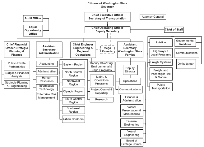
While CGIS manages the hub of GIS activities, a number of additional offices are involved in the implementation of GIS at WSDOT. The GIS Support Team coordinates activities of Geographic Services, Transportation Data Office (TDO), Office of Information Technology (OIT), NW Region GIS Program and the Environmental Services Office as well as many other business areas across the agency. Geographic Services is responsible for WSDOT base map development, the linear referencing system, and GIS application development., while OIT takes the lead on user applications, data administration, data conversion, data discovery, software installation and testing. Environmental Services has led the way in adopting GIS technology as a day-to-day business tool. TDO is leading an effort to update the linear reference system using GPS as well as for development of the roadside features data inventory. In addition to the GIS Support Team, many business units and regions that use geospatial technology have GIS staff to manage data and perform analysis. The core GIS infrastructure is centrally managed by OIT and shared ArcGIS Desktop licenses are emphasized over dedicated licenses.
GIS policy and funding decisions on Department-wide GIS activities begins with the GIS Advisory Committee, made up of middle management who develops recommendations. A GIS Executive Board, which consists of higher level executives, are responsible for making final policy decisions based on the Advisory Group's recommendations.
GIS Users
Each month WSDOT has 400-500 unique GIS users. Every GIS user receives an ArcView platform with preformatted data, as well as custom tools and maps. Each user receives full functionality and has complete access to all WSDOT data. The Geographic Services Office supports users through a GIS helpdesk, as well as providing training for all GIS users. WSDOT's standard 2-day training program provides basis GIS skills, including information on what kind of data is available and how to work with the data. The second part of the course provides training on advanced GIS application work. Advanced and specialized training is outsourced.
Funding
Designated funding with the Office of Information Technology is used to maintain GIS shared software licenses. Many of the offices that use GIS to do business are either funded with a combination of state and federal dollars earmarked to support certain activities, or the offices operate as cost recovery. Alternative sources of funding include the process of taking a decision package to the Legislature to request additional funding for critical projects, or a reallocation of existing available funding. Programs that add demand for licenses and infrastructure are expected to fund incremental increases to the license pool. Dedicated licenses are funded by the programs and growth is limited by funding at this time.
Data Availability and Sharing
WSDOT develops geospatial data internally primarily through its Transportation Data Office (TDO) as well as CGIS and OIT. Much of the data produced by WSDOT, which includes transportation, political and administrative, environmental features and county base data, is made available free-of-charge to state agencies, transportation partners and the public via the centralized WSDOT GeoData Distribution Catalog.88 The data is made available in several formats including ESRI shapefiles, georeferenced .jpg and MrSID formats. In addition to the data developed internally, WSDOT also meets its GIS data needs through data sharing agreements with state agencies, including the Department of Fish and Wildlife, Department of Health, and the Department of Natural Resources as well as other data sources.
Another source of GIS data is the Washington State Geospatial Clearinghouse89. The Clearinghouse is maintained by the Washington Geographic Information Council (WAGIC), a statewide body responsible for coordinating and facilitating the use and development of the state's geospatial information. The Clearinghouse stores GIS data collected by state agencies, where other state agencies and the public can access it for download.
WSDOT is involved in two additional statewide projects. WSDOT is building a Transportation Framework, called WA-Trans.90 WA-Trans is a statewide transportation database of location-based transportation data to use in GIS across that state, and will contain the best available data from all levels of government, including tribal nations, for roads, rails, ferries, ports, aviation and non-motorized transportation infrastructure. The data will be seamless, connected, consistent and continuous between jurisdictions and political boundaries. The second project is the Statewide Orthophoto Program, where WSDOT is partnering with state and local agencies to produce and share orthophoto data. The cooperative approach for the production of orthophotos allows participating agencies to cost-share on the flight costs and minimize duplication of flying efforts. WSDOT and the WA Department of Natural Resources are designated as the stewards for the ortho framework. Currently there is a mix of public demand and fee based data sharing.
Key Success Factors and Recommendations
- Establish Support from High-Level Decision-makers - In order for management to reallocate and invest funding to develop the critical datasets necessary to perform spatial analysis, they must understand and believe in the value and benefits of performing spatial analysis. Championing the role that GIS can play in supporting and improving decisionmaking processes has come from several different offices throughout WSDOT, including Real Estate Services who are pushing for the advancement of GIS to help them perform their responsibilities, and from Environmental Services who demonstrate how useful GIS can be in implementing the day-to-day office activities. Other groups supporting GIS implementation include Systems Analysis and Program Development using GIS for the Highway Construction program development, the Transportation Data Office is using GIS for roadway and roadside features, Maintenance is using GIS for management of operations, planning for developer review and long range planning, and the Traffic Operations office is using GIS for asset management
- Involve GIS in the Project Management Process - GIS has typically been considered in an ad-hoc format throughout the transportation decision-making process. Involving the Cartography and Geographic Information Systems (CGIS) section staff and Office of Information Technology staff in the project management process will enable staff to make proactive decisions on where GIS can be incorporated, providing a more efficient process than the current wait and see course of action. There have been mixed successes in defining roles with the office of Information Technology to ensure consideration of GIS in applications.
- Plan for GIS Needs Department-Wide - WSDOT has historically worked with individual Offices on the development of GIS applications. By making decisions in silos the Department has missed opportunities to coordinate GIS application and data needs throughout the agency. WSDOT is beginning to view GIS in the parameters of the big picture where by individual program requests can be rolled into one generic application that can customized to support everyone's needs. A more comprehensive needs assessment is in progress.
References
11GeoStor: https://gis.arkansas.gov/ (back)
12https://egis3.lacounty.gov/dataportal/2011/11/22/california-spatial-information-library-casil/ (content no longer available) (back)
13Dynamic segmentation makes it possible to visualize (using a map) information that is stored in a tabular form. (back)
14The Colorado Department of Local Affairs was ESRI's 11th customer. The Department purchased its first ESRI product in 1981. (back)
1550 States Initiative (2005): https://www.fgdc.gov/policyandplanning/future-directions/action-plans/FD_PART_Fifty_States_Contributing_NSDI_Final_Action_Plan_v9.pdf (back)
16State of Connecticut Geospatial Information Systems Council: https://portal.ct.gov/OPM/IGPP/ORG/GIS2/GIS-Office (back)
17Connecticut Framework Data Themes Final Report: https://portal.ct.gov/DEEP/GIS-and-Maps/Geographic-Information-Systems (back)
18For example, the Oklahoma Department of Transportation has demonstrated a successful experience in starting its GIS enterprise modestly; the program quickly gained momentum as the DOT showcased the program's achievements at every step of implementation, and GIS eventually evolved to an enterprise system. See Oklahoma DOT Case Study from Phase 1 of the work presented here, www.gis.fhwa.dot.gov/documents/gis_business_models.pdf. (back)
19NCHRP 20-27(2), A Generic Data Model for Linear Referencing Systems: https://www.trb.org/Transportationgeneral/Blurbs/154169.aspx (back)
20Open Geospatial Consortium, Inc: https://www.ogc.org/ogc (back)
21Publication no longer online. (back)
22See Idaho Geospatial Office at https://gis.idaho.gov/ (back)
23https://itd.idaho.gov/road-data/ (back)
24https://iplan.maps.arcgis.com/apps/webappviewer/index.html?id=06e0f910357340c5816d2214266660cd (back)
25Indiana Geographic Information Council: https://www.igic.org/ (back)
26Indiana GIS Atlas: https://www.in.gov/gis/indianamap/ (back)
27Iowa Geographic Information Council: https://www.iowagic.org/ (back)
28Kansas Collaborative GIS Breakthrough Team: https://hub.kansasgis.org/pages/projects (back)
29The GIS Breakthrough Team's "Guidebook for County GIS Implementation" is available at http://www.teamtechinc.com/kansas_collaborative/resource.html#anchor11. Content no longer available. (back)
30See www.da.ks.gov for a schedule of and minutes from GIS Policy Board meetings. Content is no longer available. (back)
31More information on the Data Access and Support Center can be found here: https://www.kansasgis.org/ (back)
32More information on KGATE: https://kdotxtra.ksdot.gov/kgate/index.aspx (back)
33KDOT's 511 Road Condition Real Time Map: https://www.kandrive.org/kandrive/@-101.43512,39.04521,6?show=roadReports,constructionReports,trafficSpeeds,winterDriving,weatherRadar (back)
34KYGONET: https://kygeonet.ky.gov/ (back)
35KGSGeoPortal: https://kgs.uky.edu/kgsmap/KGSGeoPortal/KGSGeoPortal.asp (back)
36Jim Mitchell, "LA update" PowerPoint presentation. 2006. Presentation available for download at http://wwwsp.dotd.la.gov/Business/Pages/GIS_Maps.aspx (back)
37Louisiana GIS Council: https://www.doa.louisiana.gov/doa/osl/gis-data/ (back)
38GIS Executive Council, About Us: https://www.maine.gov/megis/about/ (back)
39GIS Stakeholders: https://www.megug.org/ (back)
40On April 9, 2002 the Governor signed into law L.D. 2116 "An Act to Establish the Maine Library of Geographic Information (Chapter 649). www.maine.gov/geolib/ (back)
41Maine GIS Data Catalog - https://www.maine.gov/geolib/catalog.html (back)
42MEGIS Maps - https://www.maine.gov/geolib/maps/index.html (back)
43MaineDOT. Location Referenced Transportation System Database, Reporting on: Transportation Integrated Network Information System and Transportation Information for Decision Enhancement. Content no longer available online. (back)
44Executive Office of Transportation, Office of Transportation Planning Roads - April 2007: The layer is the official state-maintained street transportation dataset available from EOTPW and represents local and major roadways, including designations for Interstate, U.S. and State highways. (back)
45Road Inventory File Updating Process: https://www.mass.gov/orgs/massgis-bureau-of-geographic-information (back)
46MassGIS website: https://www.mass.gov/orgs/massgis-bureau-of-geographic-information (back)
47MassGIS Legislative Mandate: https://www.mass.gov/massgis-standards-and-best-practices (back)
48Strategic Plan for Spatial Data Infrastructure in Massachusetts: https://www.fgdc.gov/initiatives/50states/MA_StratPlan_Final.pdf (back)
49Road Inventory Interactive System: http://www.mngeo.state.mn.us/chouse/data.html. Content no longer available. (back)
50Minnesota's Spatial Data Infrastructure: http://www.mngeo.state.mn.us/chouse/index.html (back)
51Minnesota's Geographic Data Clearinghouse: www.mngeo.state.mn.us/chouse/ (back)
52The Geodetic Monument Viewer is available at: https://www.dot.state.mn.us/maps/geodetic/ (back)
53The Statewide Archaeological Predictive Model is available at: https://www.dot.state.mn.us/maps/geodetic/ (back)
54Minnesota DOT Interactive Basemap: https://www.dot.state.mn.us/maps/geodetic/ (back)
55Mississippi Automated Resource System (MARIS): https://maris.mississippi.edu/ (back)
56Mississippi Coordinating Council for Remote Sensing and Geographic Information Systems: https://www.giscouncil.ms.gov/ (back)
57Location Information System (LOIS): https://gis.dot.nv.gov/lois/ (back)
58Traffic Information Access (TRINA): https://geohub-ndot.hub.arcgis.com/apps/NDOT::trina-new/explore (back)
59New Jersey Geographic Information Network: https://njgin.nj.gov/ (back)
60State of New Hampshire Geographic Information System (GIS) Strategic Plan: https://www.nh.gov/osi/planning/services/gis/documents/strategic-plan.pdf (back)
61NH GRANIT: https://granit.unh.edu/ (back)
62GIS implementation plan (completed June 1993) available from NYSDOT, upon request. (back)
63Due to this organizational transition, an organization chart for NYSDOT is not currently available. (back)
64New York State Office of Cyber Security and Critical Infrastructure Coordination: https://its.ny.gov/ciso (back)
65New Models of Collaboration: GIS Coordination in New York State: https://gis.ny.gov/coordinationprogram/reports/documents/New-Models-of-Collaboration-GIS-Coordination-in-NYS.pdf (back)
66Real-Time Transportation Status: https://511ny.org/ (back)
67Geodetic Control Viewer: https://login.dot.ny.gov/nysdotsso/nysdotssologin.jsp?site2pstoretoken=v1.2~A549D4E0~EDC4AC7E2024C5CC645DA065E19AB4F0CBAA357808F36032AEB02C01B0DAEC213772CF5D3891F2846B46A051F603417D8E524D16BAB921AD4C63B363B32CC62B4724BF26E3BC4B2B7351CB6A4C55E2C9067D510595361EB2EAE0AF7EE277943A19E54379DD4D0B880F125175ABDC21F4D2C83C7855E6C3CED211E23E9D8395A9139AE8EDD02B932D232B4E49131DCEDE3A03BCBF8520911607536BBFAB077A0549FF8D24A8935199130A576AFC182F6DC9F290F4A0B2500A67B5AA5216518CA8363955FB81B456978AC5D99AB5F5A2ADE89B28F6F68F57E287B13842D8002AB8D03AE9EDEBEAB850B5F9B261F9DD54EC&p_error_code=&p_submit_url=https%3A%2F%2Flogin.dot.ny.gov%2Fsso%2Fauth&p_cancel_url=https%3A%2F%2Fwww.dot.ny.gov%2Fportal%2Fpls%2Fportal%2FPORTAL.home&ssousername= (back)
68Over Size/Over Weight Pre-Screening Tool: www.dot.ny.gov/gisapps/osowscreen (back)
69North Dakota GIS Hub: https://www.gis.nd.gov/ (back)
70North Dakota Road Conditions Map: https://www.dot.nd.gov/roadreport/roadreport/roadreportinfo.htm (back)
71Ohio DOT Business Plan Addendum: www.dot.state.oh.us/policy/2006-2007BusinessPlan/Documents/BusinessPlan06-07_Addendum-Sept.pdf. Content no longer available. (back)
72Ohio Statewide Imagery Program:https://das.ohio.gov/technology-and-strategy/OGRIP (back)
73ODOT Asset Management Program: http://www.oregon.gov/das/eam/Pages/index.aspx (back)
74In its GIS Strategic Plan, Iowa DOT provides a summary of PennDOT's plan, which was used as a model: https://intrans.iastate.edu/app/uploads/2018/03/gis_implementation_plan.pdf (back)
75Also see https://www.fhwa.dot.gov/asset/ for more information on the background and history of PennDOT's GIS program and the first Strategic Plan. (back)
76This division is located in the Bureau of Highway Safety and Traffic Engineering Safety. (back)
77PennDOT's Online Video Log: https://gis.penndot.gov/Videolog/ (back)
78PennDOT's Internet Traffic Monitoring System: https://www.dot.state.pa.us/public/Bureaus/BOMO/Portal/TSPortal/TSCC.html (back)
79"Top 10 Suggestions to Insure GIS Implementation" April 1995. PDF document available from PennDOT upon request. (back)
80Tennessee's Base Mapping Program: https://www.tn.gov/finance/sts-gis/gis/projects.html (back)
81TNMap: https://tnmap.tn.gov/ (back)
82Town highway maps for the most current year are available at: https://vtrans.vermont.gov/planning/maps/town-maps. (back)
8319 V.S.A § 305(g) directs VTrans to "provide each town with a map of all of the highways in that town together with the mileage of each class 1, 2, and 3 highway and such other information as the agency deems appropriate." From "Town Highway Maps - Purpose and Production" by VTrans Policy and Planning, Mapping Section (May 2007) https://vtrans.vermont.gov/planning/maps/town-maps (back)
84Town Highway Maps - Purpose and Production. VTrans Policy and Planning, Mapping Section. May 2007. https://vtrans.vermont.gov/planning/maps/town-maps (back)
85VTrans Route Log System: https://vtrans.vermont.gov/planning/maps/route-logs (back)
86Information about VDOT's GIS Integrator enterprise warehouse: http://vdot.virginia.gov/business/locdes/gis.asp (back)
87Virginia's online, geospatial data portal: https://data.virginia.gov (back)
88WSDOT GeoData Distribution Catalog: https://gisdata-wsdot.opendata.arcgis.com/ (back)
89Washington State Geospatial Clearinghouse: https://geo.wa.gov/ (back)
90WA-Trans, WSDOT's Transportation Framework: https://wsdot.wa.gov/engineering-standards/performance-framework (back)