AUGUST 2015
A Newsletter from the Federal Highway Administration (FHWA)
www.gis.fhwa.dot.gov
Solving Clean Water Act Requirements by Leveraging the ArcGIS Online Platform
This edition's Q&A is with John Olenik and Robbie Prezioso of the Virginia Department of Transportation (VDOT). They discuss VDOT's development of a custom, cloud-based field data solution to support VDOT's stormwater runoff responsibilities.
What transportation needs existed at your agency? How did the use of geospatial technologies address these needs?
The Virginia Department of Transportation (VDOT) is charged with the responsibility to ensure that stormwater runoff from its roadways and facilities in urbanized areas are in compliance with regulations set by the Federal Clean Water Act (CWA) and the Virginia Stormwater Management Act. Under the supervision of the Virginia State Water Control Board, which has the power to issue General Permits for Stormwater Discharges from Small Municipal Separate Storm Sewer Systems (MS4s) to the surface waters in Virginia, VDOT was on a mission to establish control measures and best management practices (BMPs) to help improve and maintain compliant water quality in the state. Part of this initiative was to create a program for Illicit Discharge Detection and Elimination (IDDE). This program provides guidance and procedures to develop, implement, and enforce the IDDE program which includes updating its storm sewer map within 48 months of issuance of the permit. Not only this, but the permit requires MS4 operators to field inspect and map all MS4 outfalls located within newly defined urbanized areas.
Because of the specific needs VDOT has to comply with these regulations and perform a vast amount of field inspection and data collection, the agency sought the assistance of EEE Consulting, Inc. (EEE), JMT Technology Group (JMT), and Louis Berger to create a custom, cloud-based, field data collection solution using their Esri ArcGIS Online subscription paired with Esri's Collector for ArcGIS mobile application.
Why was this set of tools chosen to meet stormwater management needs?
This solution was chosen because of its versatility and mobility for collecting data in the field. It provides access to an existing organization's subscription to ArcGIS Online, Esri's cloud-based mapping platform, leveraging investments already made by VDOT. ArcGIS Online provides a secure enterprise environment and a centralized repository for all authoritative data sources collected in the field. Using this application, VDOT had the ability to increase transparency and heighten collaboration across its own teams as well as the US Army Corp of Engineers (USACE) and support contractors. With this implementation, VDOT had access to a free and easy-to-use mobile application that works directly with ArcGIS Online and is available for iOS or Android platforms. Those who needed to collect data in the field were able to perform on- or off-line data collection, taking advantage of their mobile device's camera and GPS units. It is also able to integrate with Esri's suite of GIS tools and can easily share data across other VDOT organizations.
Who currently uses ArcGIS Online? How do VDOT employees use the application to meet transportation needs?
VDOT, with the help of JMT, created the MS4 Group in its ArcGIS Online account. Through ArcGIS Online, VDOT is able to invite users to participate and view the services published within the MS4 ArcGIS Online Group.
There are currently 56 assigned members that have access to the VDOT ArcGIS Online - MS4 Group including staff from the following VDOT departments: Environmental - Natural Resources Department, Environmental - Hazardous Materials Department, Maintenance, and Location & Design. Members also include support staff from the three USACE districts and consultants.
VDOT tasked the consultant with the preparation of a series of feature, tile and web map services. The web map services consist of a combination of feature service(s), tile service(s), map service(s), and a base map. Individual web maps were prepared for three USACE Districts within Virginia and contractor support teams who are performing the field inspections. Each USACE District and contract support team has an individual web map to cover their specific area of responsibility. Individual web maps were prepared to eliminate error in data entry among the teams. While each District or team has their individual web map, all web maps within the MS4 Group share a common theme through a set of basic feature services, tile services, map services, and aerial imagery base maps. Specifically, the web maps consist of an inventory feature service, an outfall feature service, a VDOT roads tile service, a target area tile service (i.e. cluster areas), the US National Hydrography Dataset (NHD) map service, and an aerial base map (using either Esri or Bing imagery).
VDOT and JMT configured the web map properties with the appropriate definitions, tags, cartographic symbols, and shared them on the MS4 Group. Once the services are published onto ArcGIS Online, all data is stored and maintained in the cloud. This allows VDOT staff, as well as any USACE District or contractor support outside of the VDOT intranet, to have direct access and ability to edit the data at any time using the ArcGIS Online web application. The published web maps are also viewable and editable through the Collector for ArcGIS mobile application.
VDOT's Maintenance Division, USACE District, and supporting contracting staff are assigned specific areas for outfall collection and screening based on their geographic area of responsibility and clustered areas. The agency and its consultants use the Collector for ArcGIS to perform and complete the field inspections. In performing the inspection, users take advantage of the GPS and Camera built into the device. Users collect pertinent attribute information of the asset, capture the asset's location by manually pinpointing the asset on the map or by using the GPS unit, and take pictures of the asset, capturing the current condition and attaching the image to the GIS feature. With the Collector for ArcGIS, users have the option to perform the inspection in a connected or disconnected environment (using network or Wifi service). Users perform the work in a disconnected environment when the network or Wifi service is weak or not available. Once the user is able to reconnect to the Internet, the data can be synchronized in the map service to ArcGIS Online.
Once the field inspection is complete, VDOT, USACE, and contract support staff use the Report Generator desktop application to connect to the VDOT ArcGIS Online account to export a copy of feature layers into a file or personal geodatabase, create a project directory folder structure on a local machine, download the photo attachments and storing the images into their respective project folder, insert water marks on the images with pertinent IDDE asset information, and create custom reports. The data can be further utilized by additional follow-up investigations in the field, if necessary.
What was the process of identifying and developing the solution?
VDOT's Maintenance Division identified the need for a new field data collection solution to better support MS4 regulatory compliance and the goals of the IDDE Program and Stormwater BMP. In the fall of 2012, VDOT Maintenance Division representatives initiated support from Esri to document VDOT's field data application requirements and prepare a design approach that applied geospatial technologies to meet their needs. The detailed design specification was delivered in January 2013 but encountered funding issues.
Meanwhile, JMT was supporting the IDDE field inspection using the internal ArcGIS Online account and Collector for ArcGIS. Seeing the efficiency of the field data collection solution using ArcGIS Online, VDOT sought out the consultant's support to implement the same solution for them. VDOT's Location & Design as well as their Maintenance Divisions utilized its existing MS4 Program Implementation Services Contract to support an ArcGIS Online implementation. In September of 2013, JMT, EEE, and Louis Berger provided a demonstration and training to VDOT and USACE staff on the solution. Then, in October 2013, the solution was deployed to field inspectors. Support services continue to be provided to VDOT'S ArcGIS Online and Collector for ArcGIS solution by the team of consultants.
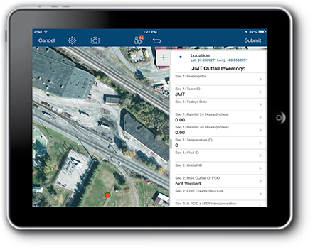 Figure 1. VDOT's MS4 Mobile Collection Tools
What other factors contributed to use of ArcGIS Online in this way?
Recognizing that the consultant would be able to deliver a solution within a short turn-around period and within a small budget, and that they could use an out of the box commercial off-the-shelf (COTS) solution instead of developing a custom application, VDOT had all the tools it needed to implement an efficient, versatile solution. The solution also used VDOT's existing ArcGIS Online subscription, an existing technology in which VDOT had already invested. Last, the Collector for ArcGIS mobile application was free, simple to use, and could be implemented across VDOT, USACE and other support contract staff.
Where do you obtain data for the ArcGIS Online solution?
VDOT developed a GIS data model to generate target areas of investigation, and it uses the most up-to-date Environmental Protection Agency (EPA)/US Census Bureau urbanized area boundaries, the National Hydrography Dataset (NHD) from the US Geologic Survey, and the National Wetland Inventory (NWI) dataset from the Fish and Wildlife Service. It also uses VDOT's road centerline data, IDDE point location, and District boundary GIS data layers. VDOT was also able to purchase a subscription to the Bing aerial imagery basemap (from Microsoft) which is used in conjunction with Esri's basemaps (i.e. street, topology, and aerial imagery).
Were there challenges in securing funding for the solution?
VDOT's Location & Design Division (L&D) is administering the MS4 Program and is supported by VDOT IT Division who is providing the ArcGIS Online subscription. The Maintenance Division is implementing the mobile field data collection pilot program using ArcGIS Online and Esri's free mobile Collector application. L&D was faced with several challenges with implementing and securing funds for this pilot program due to internal stakeholders' reservations with the new technology. The division raised questions regarding whether or not the solution could integrate with the existing mission's goals. Hesitant to fund a project that could create a black box silo solution, multiple VDOT departments were highly involved in the project. Each department had a stake and role in the program, which created challenges with identifying how to break out cost responsibilities.
How has the use of the application and geospatial technologies met the transportation and business needs of your agency or department?
Use of this process has greatly enhanced the efficiency of field data collection. It has helped to eliminate many hours of searching for outfalls in unlikely areas. It has also helped to assure that the dataset is consistent, regardless of the individual field staff.
The implemented technology met VDOT's transportation and business needs in that it provided a cost-effective and time-sensitive solution to maintain permit compliance. The number of outfalls that have been collected and screened since the implementation of the technology has more than doubled. The technology has met VDOT's technical aspirations by utilizing existing VDOT technologies and investments, while heightening the MS4 program transparency, enabling collaboration and further integration across other VDOT programs.
Are there future plans to change or modify this application or how geospatial technologies are used?
Future enhancements to the VDOT MS4 IDDE program will build upon the success of ArcGIS Online and the Collector for ArcGIS. These enhancements are intended to elevate the user's experience by introducing a custom dynamic field data collection form and enabling VDOT staff to generate custom reports efficiently. In addition, the success and lessons learned from the IDDE program will be used to support other VDOT programs including the MS4 Stormwater BMP inventory and other VDOT initiatives across other organizations.
What have been the critical success factors or lessons learned while applying this solution?
ArcGIS Online was a major improvement to the overall VDOT MS4 IDDE inspection program, and using ArcGIS Online forced important changes to standards in the inventory data schema, field data collection protocol, and data management and reporting process. ArcGIS Online simplified the exchange of data over the cloud while increasing communication and transparency across the three Districts. In addition, it made the state-wide field data collection more cost effective and increased accuracy while maintaining the overall safety of the investigations. The use of ArcGIS Online significantly reduced the amount of time spent on gathering and reconciling data collected from the Districts, removed the need for paper forms and users re-entering data into a flat database, and eliminated errors with transposing data from the field to the database. ArcGIS Online and the Collector for ArcGIS improved field data collection by implementing a standard, simple-to-use field data collection application. Finally, it allowed users to view data collected in the field in near real-time, giving immediate information to supporting team members and quality assurance managers.
John Olenik
VDOT - Location & Design Division
(804) 371-0366
John.Olenik@vdot.virginia.gov
Robert (Robbie) Prezioso
VDOT - Maintenance Division
(804) 786- 0816
Robert.Prezioso@vdot.virginia.gov
GIS and Transportation Asset Management
Editorial from Frances D. Harrison, Spy Pond Partners, LLC, and Connie Gurchiek, Transcend Spatial Solutions
Every year at the AASHTO GIS-T Symposium, the Task Force surveys State DOTs on their use of geospatial technologies. A consistent survey result over the past several years is that Asset Management is viewed as one of the areas where geospatial technology can add the most value. That's the good news. The bad news is that Asset Management is also viewed as one of the most costly and difficult areas in which to implement geospatial technology. These results make sense. By its very nature, Asset Management is about integrating information across organizational silos to make better decisions. GIS is a perfect solution for this. But that “integrating across silos” part also is what makes GIS for Asset Management costly and difficult.
NCHRP Project 8-87 was initiated in 2012 to help advance the state of the practice in GIS-Based Asset Management. Its objectives were to:
- Develop guidance for how State DOTs and other transportation agencies can enhance their asset-management capabilities through effective adoption of GIS technologies, and
- Encourage more extensive adoption of GIS technologies by conducting pilot demonstrations and workshops on implementation of GIS-based Asset Management.
The project was completed in 2014 and the results were published as NCHRP Report 800 in March of 2015. Key products are a short Executive Guide that highlights opportunities and benefits, a longer Implementation Guide for practitioners, and pilot demonstrations that illustrate how GIS can benefit Asset Management.
With this project now in the rear-view mirror, three key lessons stand out about how to achieve success using geospatial data and technology for Asset Management:
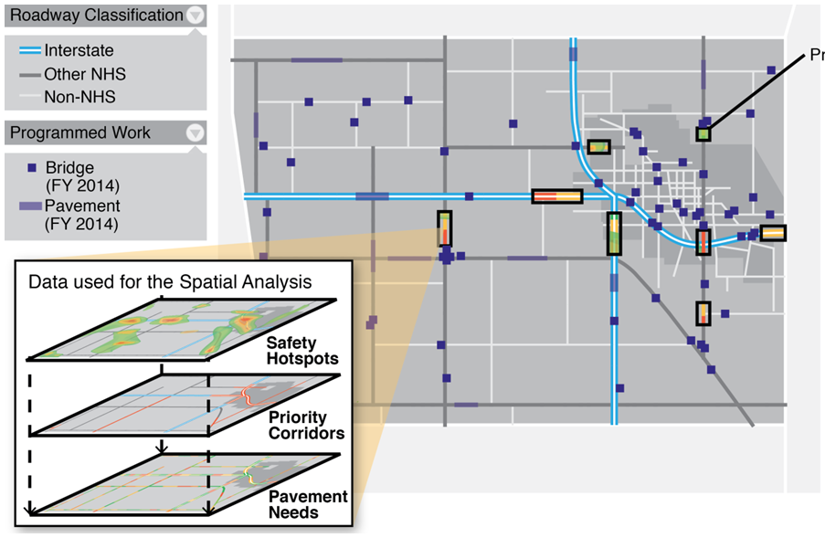 Figure 2: Implementing GIS for Transportation Asset Management
- Architectural Vision. Sharing information across pavement, bridge, safety, maintenance management, capital project management, and roadway inventory systems is a continuing challenge. The most fully-featured, spatially-driven Asset Management systems identified in the project were single-vendor, integrated solutions. These systems were typically deployed at the municipal level. Most State DOTs, on the other hand, have implemented “best of breed” (i.e. considered most advanced or fully featured within a given niche area) solutions for different assets and different stages of the asset life cycle. This approach is advantageous in many respects, but presents very significant integration challenges to combine data and analysis results across systems. These challenges require strong leadership and innovative solutions to overcome. Agencies must create a vision for how they want their systems to work together, then work with vendors and internal information technology staff to move towards that vision.
- Collaboration. Getting to the next level of sophistication beyond “Let's collect data and make a map of our assets” requires collaboration between Asset Management business leads and staff who understand what geospatial technology can do. Having the technology—and even having the data—is not enough. Asset managers need to be engaged in a conversation about how a spatial view of information could provide new insights that they don't currently have.
- Experimentation. As a corollary to lesson #2, advances in practice take iteration and experimentation. That was clearly evident in the project as we worked with several State DOTs to mock up spatial capabilities and construct a story line about how these capabilities would be used to support Asset Management processes. Scenarios included diagnosing reasons for rapid pavement deterioration, enhancing the efficiency of work planning and tracking, and integrating risk analysis results into geospatial project planning. In each case, we began with a business question, and then moved on to assembling available spatial data that could help answer that question. The next task was to determine how to summarize and display the data in a meaningful way, and how to avoid the “layerreah” phenomenon (i.e. too many layers and too much information to process). Finally, we considered how this information would be shared across different business units in the agency, and how it would be integrated into decision making processes. Multiple cycles of experimentation with different scenarios were necessary before we had a coherent story line. To support this process of experimentation, it is important for asset managers to have ready access to staff who understand geospatial data and technology and who can work in an iterative fashion responding to new needs as they arise.
For more information, please contact:
Frances D. Harrison
Email: FHarrison@spypondpartners.com
Phone: (671) 500-4875
Connie Gurchiek
Email: CGurchiek@tssgis.com
Phone: (941) 359-9697
Other News
SCDOT - Projects, Programs, the STIP and MAPS: Sharing Project Info with the Enterprise:
Webcast Summary Now Available
A summary of the most recent GIS in Transportation webcast is now available on the GIS in Transportation website. Lynsee Gibson of the South Carolina Department of Transportation (SCDOT) discussed SCDOT's project management and programming system, P2S, and its eSTIP system (currently in development). Both applications use SCDOT's existing LRS to tie project management and funding to geographic locations. See this link for more: www.gis.fhwa.dot.gov/webinars/webinar26_sc.aspx.
GIS for Transportation Performance Management: Upcoming Peer Exchange and Case Study Reports
FHWA sponsors peer exchanges, in which GIS practitioners gather to share and learn about effective practices, methodologies, and lessons learned about the use of GIS to support transportation decision-making. This summer, FHWA hosted a peer exchange looking at how local and State transportation agencies are using geospatial tools to implement transportation performance management programs or initiatives. FHWA is currently conducting case study interviews develop a companion report to the peer exchange summary. Both reports will be available this winter at www.gis.fhwa.dot.gov/reports.aspx.
Making a Business Case for GIS: Upcoming Case Study Report
This spring, FHWA held a peer exchange on how transportation agencies are making the business case for GIS applications or geospatial tools. A case study report based on the peer exchange discussion and case study interviews, will be released this fall at www.gis.fhwa.dot.gov/reports.aspx.
Regional Models of Cooperation: Upcoming Case Study Report
This spring, FHWA conducted case study interviews with agencies that are using GIS to enhance multijurisdictional cooperation, in association with FHWA's Every Day Counts (EDC) program. This report will be available this fall at www.gis.fhwa.dot.gov/reports.aspx.
For more information about this newsletter, please contact Mark Sarmiento, FHWA Office of Planning, at Mark.Sarmiento@dot.gov.

