FALL 2013
A Newsletter from the Federal Highway Administration (FHWA)
www.gis.fhwa.dot.gov
A Look at Road Network Management in Baton Rouge,
Louisiana (LA)
This edition's Q&A is with Warren Kron, GISP, GIS Coordinator, and Justin Priola, GISP, Senior GIS Analyst, of the City of Baton Rouge and Parish of East Baton Rouge (City-Parish), LA. They discuss the conversion of the City-Parish's GIS road network to a linear referencing system (LRS).
Upcoming Events
- Transportation Research Board (TRB) Annual Meeting
January 12-16, 2014
Washington, D.C.
See www.trb.org/AnnualMeeting2014/AnnualMeeting2014.aspx
- Esri Federal GIS Conference
February 10-11, 2014
Washington, D.C.
- American Society for Photogrammetry and Remote Sensing (ASPRS) 2014 Annual Conference/Joint Agency Commercial Imagery Evaluation (JACIE) Workshop
March 23-28, 2014
Louisville, KY
- AASHTO GIS for Transportation Symposium
May 5-8, 2014
Burlington, VT
See gis-t.transportation.org/
Obtaining accurate data and information for a local roadway network is crucial for departments such as planning, public works, public safety, and 911 communication districts. It is not uncommon for departments to contend with street name duplications, several address reference system baselines, and multiple jurisdictions. Often times, a single ‘source of truth’ does not exist, and departments have to address incomplete unique identifiers, un-named private roads, and non-calibrated road networks.
How does the City-Parish store and maintain road data?
The City-Parish, like many local governments, stores and maintains street centerline data for all roadways located within its jurisdiction, and is responsible for managing and updating these data. The data exists within an enterprise GIS framework and are accessible to all GIS users who work for the City-Parish. One of the primary data maintenance responsibilities of the City-Parish Planning Commission is to maintain the geometric aspects of street segments, and associated attributes. Other City-Parish departments maintain related datasets that are specific to their needs. The geometric data are periodically updated when new development occurs, or when roads are realigned or reconstructed.
How are road data used by various departments within the City-Parish?
The centerline data are the geometric basis for various datasets pertinent to the road network. These data are used by municipal departments in the process of carrying out their functions. Emergency Medical Services, for example, relies on dependable centerline data to locate a caller in case of emergency. This information is used to direct first responders to the location via the shortest route. The Department of Public Works uses centerline data to manage roadway characteristics such as right-of-way width, pavement type, and locations of manholes. Also, while the City-Parish maintains the majority of the streets, there are quite a few roads in East Baton Rouge Parish maintained either by the State of Louisiana, one of the three incorporated cities, or private landowners. Regardless of the jurisdiction, roadway data and characteristics must be stored in a single database for reference purposes and for use by City-Parish departments.
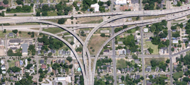 Interchange of Interstates 10 and 110 in downtown Baton Rouge.
What were the challenges associated with the City Parish's old system of data storage?
Street data in the City-Parish enterprise GIS data warehouse are stored as line segment geometry, where each centerline is a discrete roadway, and roads are broken where other roads meet or intersect. While most of the attribute data pertinent to streets can be stored using an intersection to intersection geometric format, a number of attributes cannot be efficiently stored in this manner. For instance, the beginning and end of school zones can occur either at an intersection or midblock. The same is true for changes in pavement type, speed zones, etc.
The original street data model did not meet the needs of various City-Parish users due to the shortcomings described above. These issues led users to develop duplicate sets of street data and geometries to meet the internal needs of various departments. These separate records were not synchronized, nor were the street names consistent with the Planning Commission's “Official Street Name List.”
How did the City-Parish decide to address these challenges?
To resolve this problem, a committee, comprised of representatives from all pertinent local government agencies, was formed in 2009 to review street attribute data collection practices and decide what data should be stored as an integral part of the street centerline geometry. The committee realized that certain types of data required a more dynamic type of storage method than could be provided using the intersection to intersection geometries. Dynamic storage eliminates the need to import separate datasets from other departments. To improve the way in which these data were stored, the committee decided to develop a Linear Referencing System (LRS) for the street centerline data.
How was the LRS developed and funded?
In 2011, the City-Parish obtained funding through its partnership with the U.S. Army Corps of Engineers to initiate the development of a LRS. In coordination with the contractor, the City-Parish performed extensive preparatory work on the centerline data to ensure its geometric validity. The LRS allowed the City-Parish to put standards into place to create an official repository for both buildings and street names. As a result, analysts were able to validate the street name and building permit databases to ensure that the information contained in each was correct. Also during this quality assurance phase, the Planning Commission digitized all un-named private and public streets and assigned unique street name identification numbers to these segments.
How does the City-Parish manage its new LRS system?
To manage the LRS, the Planning Commission acquired a license of the Intergraph® Corporation desktop software product GeoMedia® Transportation Manager. GeoMedia® Transportation Manager is a data management tool optimized for maintaining and updating linear reference system centerline data. The finished product provides a powerful tool to effectively and efficiently manage accurate street data that meets the requirements of all end users.
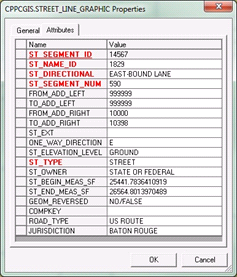 A screenshot from GIS displaying base street centerline attribute data.
What are some of the benefits of using the new LRS system?
Because the City-Parish spent significant time during the quality assurance phase, one of the immediate benefits of the LRS has been that a single user can now maintain the dataset. With the new system, the City-Parish can now collect and populate additional event tables such as traffic counts, pavement type, sidewalks, and signage. Also, it is very easy to perform periodic recalibrations to support asset and incident locations.
The LRS was originally developed as a single level, as it was believed that ‘starting simple’ would minimize any issues that might arise during the data development process. The single level LRS uses one geometry to store and manage various street-related events. In 2013, the Planning Commission decided that it was ready to ascend to the next level by establishing a multi-level LRS which will build on the success of the existing LRS. A multi-level LRS allows the users to maintain events on many geometric components of the road network.
Previously, the only way to view much of the event data, such as bike paths, road jurisdiction, and bus stops, was in a tabular format. With the LRS in place, this information can now be presented on a map using dynamic segmentation tools. This system has dissolved redundant datasets by creating one repository to store all street-related attributes. This has resulted in improved inter-governmental collaboration, more accurate street data, as well as an easier and faster way to access these data. The City of Baton Rouge is now positioned to provide data to the Louisiana Department of Transportation and Development in a format that will meet upcoming MAP-21 mandates.
For more information, please contact:
Warren Kron
WKron@brgov.com, GISP
Phone: 225-389-3144
Justin Priola
JPriola@brgov.com, GISP
Phone: 225-389-3144
Strategic Highway Research Program (SHRP 2) Roadway Information Database
Editorial from Charles Fay, Transportation Research Board, and Omar Smadi, Iowa State University
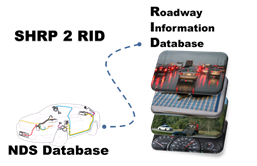 The RID data sources (Existing, Supplemental, and Mobile data) and how they should be linked to the NDS data for full safety analysis.
The second Strategic Highway Research Program (SHRP 2) conducted the world's largest and most comprehensive naturalistic driving study (NDS) to date. The study focused on six States (Florida, Indiana, North Carolina, New York, Pennsylvania, and Washington) and involved 3000 participants, who took 5 million trips and travelled more than 30 million miles overall. The study takes a systems approach to improving highway safety by combining vehicle, driver, and contextual data such as roadway, traffic, weather, work zones, safety laws, and other relevant information. Together these data will be used to determine what happens just before a crash, when drivers experience near-crashes, and when they drive without incident (exposure data). This new insight will lead to the development of safer roadways, safer vehicles, and ultimately, safer drivers.
The SHRP 2 Roadway Information Database (RID) is a spatially-enabled database, or Geodatabase, which is interoperable with the NDS driver and vehicle data. The RID accommodates contextual data from multiple sources including new roadway data collected by SHRP 2 on 12,500 centerline miles in the six study sites, and existing data acquired from government, public, and private sources on approximately 200,000 centerline miles.
The RID was designed to store, query, and manipulate geographic data, including points, lines, and polygons within a GIS environment. The data contained within the RID is published into a de-normalized data warehouse designed to improve data query and retrieval speeds as well as retain data in their most logical and elemental form.
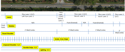 An example of the roadway data collected for the SHRP 2 RID and how the data are stored in the roadway database.
Given the disparate and spatial nature of the RID data, GIS serves as the optimal tool for integration, analysis, and visualization. GIS not only supports basic attribute and spatial-based queries but also more complex data assimilation and analysis approaches. For example, through the use of dynamic segmentation, various independent roadway-related data sets may be systematically integrated, allowing users to identify only those locations that have characteristics of interest. This functionality facilitates reporting of any or all roadway/roadside characteristics associated with a given portion of an NDS trip, allowing new, more complete analyses of driver, vehicle, and contextual data.
For more information, please contact:
Charles Fay
CFay@nas.edu
Phone: 202-334-1817
Omar Smadi
Smadi@iastate.edu
Phone: 515-294-7110
Other News
Geospatial Data Collaboration (GDC)
GDC is a new FHWA geospatial data-sharing initiative which encourages transportation agencies to use geospatial tools to share data, increase collaboration, and improve the quality and speed of transportation decision-making. The GIS in Transportation website (www.gis.fhwa.dot.gov/gdc.aspx) now houses information on the three GDC focus areas:
- Operating Agreements
- Collaborative Data Libraries
- Collaborative GIS Screening Tools
FHWA would like to hear from State Departments of Transportation and other transportation agencies about their uses of geospatial tools that support data-sharing and collaboration. Please share your examples by contacting Mark Sarmiento at Mark.Sarmiento@dot.gov (202-366-4828).
Peer Exchanges & Reports
FHWA sponsors peer exchanges, in which GIS practitioners gather to share and learn about existing effective practices, methodologies, and lessons learned concerning the use of GIS to support transportation decision-making. This spring, FHWA held two peer exchanges on the following topics:
- Applications for the Interoperability of CAD (Computer-Aided Design) and Geographic Information Systems (GIS)
- Uses of Cloud Technologies for Geospatial Applications
Case study reports based on the peer exchange discussions, as well as case study interviews conducted with each participating organization, will be released soon. These reports will be available at www.gis.fhwa.dot.gov/reports.aspx.
Webinars
FHWA sponsors a quarterly GIS webinar series that provides information about current GIS efforts, applications, and initiatives. To view previous webinars, please see www.gis.fhwa.dot.gov/webinars.aspx.
For more information about this newsletter, please contact Mark Sarmiento, FHWA Office of Planning, at Mark.Sarmiento@dot.gov.


