SUMMER 2010
A Newsletter from the Federal Highway Administration (FHWA)
www.gis.fhwa.dot.gov
A Look at Ohio DOT's Asset Management Applications
This month’s Q&A is with Fred Judson, GIS Coordinator at the Ohio Department of Transportation’s (ODOT) District 2. He discusses ODOT District 2’s use of GIS to build several asset management applications.
Upcoming Events
- GIS Tools for Strategic Conservation Planning
August 3-6, 2010
Shepherdstown, WV
- National States Geographic Information Council Annual Conference
September 12-16, 2010
Minneapolis, MN
- URISA Annual Conference for GIS Professionals
September 28-October 1, 2010
Orlando, FL
Q. What transportation needs existed at ODOT? How is ODOT using asset management applications?
A. ODOT is increasingly required to work within limited budgets, which has led to demand for more efficient use of resources and new ODOT business practices. Uses of integrated GIS standards and geospatial applications are important ways to help allocate resources over a large geographic area.
ODOT has created several state-of-the-art applications to meet these new demands, which include:
- A web-based geospatial mapping application to view and extract spatial data (see Figure 1).
- The Buckeye Asset Data Collection System (BADCS), a web-based application to view video of ODOT’s roadways with fast and efficient collection of large-scale asset inventories (see Figure 2).
- A mobile asset management application capable of operating on any Windows mobile device with a global positioning system (GPS) (see Figure 3). The GPS ensures that data are updated as they are changed in the field.
- Safe Software’s Feature Manipulation Engine (FME) to ensure data interoperability and automated data processing. The FME product supports over 250 data formats and allows ODOT to communicate effectively with its customers and internal applications that utilize proprietary formats.
The goal of all of these applications is to compile, analyze, and report on information related to the current and future condition of our roadways.
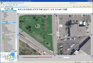 Figure 1. Mapping application screenshot.
All of the applications update with ODOT District 2’s enterprise database to ensure that they contain the most current data. They also allow the end user to extract data for use in other applications.
These applications are currently being used to support several ODOT business processes, including remote sensing, data collection, and work order management.
For example, aerial imagery in ODOT’s web-mapping application is utilized for historical and current land use identification. The web-mapping application is used to display and query most of ODOT’s current and historical geospatial assets. The mobile application is used to inventory, inspect, and perform work order application activities for several areas, such as culverts, overhead signs, curb ramps, highway lighting, and others. BADCS is utilized to extract three-dimensional coordinates from two-dimensional photographs to inventory asset locations.
Q. Why were these applications chosen as tools to meet transportation needs?
A. Except for the FME product, the asset management applications were developed in-house without use of third-party software. This has helped ensure that ODOT functions as an expert in the field and does not have to rely on vendors to address any problems (a byproduct of shrinking budgets).
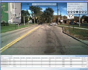 Figure 2. BADCS screenshot.
ODOT has standardized in Microsoft programming technologies and utilizes the Visual Studio development platform for all application development. This allows ODOT to capitalize on its existing investments and perform rapid application development. The BADCS and the map application are fully web- based applications programmed in Microsoft’s Silverlight to support efficient data dissemination.
The next version of the BADCS and the web mapping software will combine the traditional mapping application with the video into one comprehensive system. These applications use special formulas that allow ODOT to consume any sequence of roadway images from any vendor.
The BADCS displays video of ODOT’s transportation infrastructure and allows users to collect and measure large-scale inventories. It displays a comprehensive view of asset data with spatial filtering operations. The BADCS also allows users to export data into ODOT’s computer-aided design and drafting (CADD) and Excel systems.
Q. Who currently uses these applications?
A. The applications are currently used throughout ODOT’s Districts 1 and 2. The applications are available to all of ODOT’s 6,000 employees. However, the applications have currently been implemented only by ODOT’s District 1 and 2. Across these two districts, there are approximately 800 potential users.
The mobile software is available to anyone in ODOT. However, due to the nature of the software, use is limited to those individuals with mobile devices running Windows. ODOT currently has 12 employees running this application on their mobile phones, but District 2 plans to expand use of the software to over 50 employees by fall 2010.
Q. Who initiated the application of these applications?
A. Fred Judson led the GIS implementations within District 2 under the direction of Hiram Crabtree, Network Administrator. Two additional staff from District 2’s Information Technology Department (Ben Cordes, GPS Coordinator, and Jon Woyame, Application Developer) then joined the group. District 2 then partnered with District 1 under John Puente, Planning Administrator and GIS Coordinator.
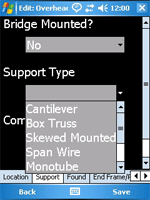
 Figure 3. Mobile application screenshots.
From 2005 to 2008, District 2 conducted research to build the applications and then entered a development and production phase from 2008 to the present.
Q. What other factors contributed to ODOT’s use of these applications?
A. Several factors encouraged development of these applications, including decreasing budgets, constraints due to existing policies and procedures, and implementations from existing vendors that did not meet ODOT’s business needs.
District 2 researched asset management for several years before building the applications. Staff surveyed several agencies, conducted field visits, reviewed technical documents, and performed vendor evaluations. After conducting this extensive research, District 2 reached the only conclusion possible: build its own applications.
Q. Are there challenges in securing funding for use of these applications?
A. ODOT cannot depend on any particular level of funding from year to year. Due to the expertise within the organization from building the products in-house, ODOT believes it has safeguarded itself against years when funding may be reduced.
Q. Where do you obtain data for the applications?
A. In addition to its own agency data, ODOT uses information from several data owners, including:
- ODOT’s central office;
- The Ohio Statewide Imagery Program, a partnership between state, local and Federal government agencies to develop geospatial data for the state of Ohio;
- Ohio’s Location Based Response System, an ODOT-sponsored program to help coordinate multi-jurisdictional spatial data;
- The Ohio Geographically Referenced Information Program Division, which is under the Ohio Information Technology Department;
- A variety of Federal, state, regional, county and municipal organizations.
Periodic viewing of ODOT’s transportation infrastructure also allows staff to collect asset data.
Q. How has use of the applications met ODOT's needs?
A. In using these applications, ODOT has not only achieved its business goals but has surpassed them. The applications have allowed the agency to collect tens of thousands of assets valued at millions of dollars in less than three months.
By storing application data in a centralized database, a user can run reports, query, and summarize information to make more informed business decisions for better resource allocations.
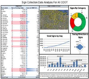 Figure 4. Sign statistics screenshot.
By implementing web-based solutions, ODOT has reached the entire organization and fostered partnerships with Ohio’s educational system.
For example, for a short period of time, ODOT partnered with Penta County Vocational School and Ohio State University’s Rhodes College GIS programs, where the agency provided greatly needed practical GIS experience. In return, students collected over 10,000 signs for the department (see Figure 4).
The asset management data are also being used to more accurately estimate maintenance activity costs and assess different sign metrics to ensure that they meet state minimum standards.
A use case for the data and application of the asset management systems occurred when a Category 4/5 tornado hit District 2’s counties. The tornado killed seven people and destroyed two miles of signs along State Route 795 and a section of Interstate 280, causing millions of dollars in damage. Using ODOT’s software, staff queried sign data and generated a report to identify the signs that were destroyed or lost in the relevant areas.
Q. Are there future plans to modify these applications?
A. The asset management process and procedures will always be in a development stage as ODOT is continuously improving and updating the applications. The technology does not remain stagnant. As an organization, ODOT needs to grow and adapt with changes and evolutions in technology.
Future development will utilize the evolving mobile market. Costs decrease when phones, computers, and GPS units merge and limitations such as GPS accuracy improves. These new devices become more attractive for use in inventory, inspection, and work order management.
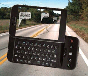 Figure 5. Potential use of augmented reality application.
ODOT District 2 plans to implement augmented reality for locating assets in the field (see Figure 5). By utilizing the camera feature that is standard with all modern phones, staff can overlay assets onto a video, presenting a real-time view of asset locations through the phone’s display. As the user changes his or her position, asset locations will update on the screen.
Q. What have been the critical success factors or lessons learned?
A. ODOT has learned that it knows its business better than any vendor, professor, or consultant. Additionally, an important lesson learned is that budgets are unreliable. ODOT researched many asset management solutions and explored acquiring services or purchasing products. As a result of this research, ODOT learned that the benefits gained from developing the applications in-house far outweighed any costs in research and development time.
As a state agency, ODOT is dedicated to delivering the best value to taxpayers and developing technologies that advance GIS and geospatial knowledge.
For more information, please contact Fred Judson, GISP, at Fred.Judson@dot.state.oh.us
Editorial from Eric Abrams, Iowa DOT
Enterprise Geospatial Web Services – Avoid Silos of Excellence
We have all been there or are still in an environment of application-centric GIS systems. Application-centric GIS systems meet specific project needs without focusing on how other users or systems can consume the data. Offices, users, or other systems needing data must make standalone, hard-wired connections to databases, files, various GIS formats, or follow obscure security rules.
Enter the GIS “silo of excellence,” a closed, application-centric system in which data is not easily accessible or useable to those outside the system.
Implementing geospatial web services can help GIS systems move from an application-centric silo of excellence to a processed-based environment.
Processed-based GIS systems have the freedom to combine and reuse multiple datasets. In a geospatial web services system, Information Technology (IT) staff can also upgrade or change back-end technology without impacting system security or data access.
Development and deployment of successful geospatial web services require five tiers; standards, producers, geospatial web service, application and consumers.
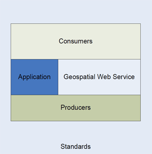 Framework tiers for successful enterprise geospatial web services.
Standards provide a blueprint for systems and processes. These standards can include a common database or governance and guideline documents. Producers create, manage, and maintain data stored in a central environment (e.g., databases, flat files). The application tier consumes data from the geospatial service.
Geospatial web services harvest data; producers expose and make data available via a Web Map Service (WMS) or Web Feature Service. Essentially, producers directly bundle and package information for consumers.
Iowa DOT is moving quickly toward a Simple Object Access Protocol (SOAP)-based geospatial web service. Iowa DOT stores enterprise spatial data in Oracle Spatial. Producers manage and maintain data in this central location while leveraging Oracle’s native data access rules and design structure.
Iowa DOT’s implementation of ArcGIS server gives IT and users the ability to develop applications based on technologies like JavaScript API. Users can also access WMS to display data in custom desktop or web applications.
The common standards and framework offered by SOAP allows Iowa DOT to create web services on top of Oracle Spatial and the Linear Referencing system (LRS).
Iowa DOT’s LRS web services give applications the ability to transform data from one linear referencing method (LRM) to another. For example, LRS could allow applications to transform reference post number 113.56 on Interstate 35 north to mile point 5.8 on a county border. Moreover, Iowa DOT’s LRS web services can coordinate LRMs without needing to tie the LRS and business databases together.
Consumers benefit from being able to integrate, view, and work with multiple datasets when needed. They also have access to a one-stop shop for information.
DOT GIS business needs today require more efficient and accessible ways to access spatial and business data. More IT processes are moving towards web services and GIS systems should follow suit to avoid silos of excellence.
For more information on Iowa DOT’s SOAP-based geospatial web service or on silos of excellence, please contact:
Eric Abrams
GIS Coordinator
Iowa DOT
iowadot.gov
eric.abrams@dot.iowa.gov
(515) 239-1723
Other News
Website Update
FHWA has updated the GIS in Transportation website at www.gis.fhwa.dot.gov. The new website offers information on GIS events, industry news, and innovative GIS applications from around the country, as well as the FHWA GIS in Transportation quarterly webcasts and newsletters.
New Report
FHWA recently released a new report related to applications of GIS for transportation decision-making purposes. This report, listed below, is available along with many others at www.gis.fhwa.dot.gov. Visit the site to learn more as well as to submit information about your agency’s transportation GIS applications.
Current Uses of Web 2.0 Applications in Transportation (March 2010) - This report presents seven case studies that illustrate how select state Departments of Transportation are using web 2.0 technologies to meet business objectives such as data analysis and information provision. Web 2.0 technologies in use include GIS-based mashup maps, social media, wikis, and other types of applications.
For More Information
For more information about this newsletter, please contact Mark Sarmiento, FHWA Office of Interstate and Border Planning, mark.sarmiento@dot.gov.


