Webinar 37
Slimgim Maturity Model & Slimgim-T Development
May 31, 2018
Summary of the Federal Highway Administration’s Quarterly Webinar: Applications of Geospatial Technologies in Transportation
Background
The Federal Highway Administration (FHWA) has promoted Geospatial Information Systems (GIS) as a means to more effectively manage and improve transportation systems. One of the ways that FHWA has done this is through its GIS in Transportation program,1 which identifies timely and critical GIS issues and topics in transportation and connects transportation agencies with available resources and best practices. The webinar summarized here is part of a quarterly series, which is organized through the GIS in Transportation program.
Eric Abrams presented on his experience using the Slimgim Maturity Model. He also discussed the development of the Slimgim-T Maturity Model, a unique maturity model specifically for transportation agencies.
A recording of the webinar can be viewed here.
Introduction
Maturity models provide a framework for creating a shared vision and common language for an organization’s goals, and can be used for benchmarking the progress towards those goals. Transportation organizations have certain requirements when it comes to maturity models for the exercise to be effective, such as Executive Support and Governance.
- Ad hoc (Think local, act local)
- Planned/Early Stage (Think global, act local)
- Partially Implemented (Think global, act collectively)
- Enterprise (Think global, act globally)
- Optimized (Work global, act globally)
The results from the Iowa Department of Transportation’s (DOT) maturity model were shown as an example of how the maturity model ranks an organization’s capabilities and activities within a given category.
Slimgim Maturity Model
Iowa DOT began looking for GIS-specific maturity models in 2013/2014, and decided to start using the Slimgim Maturity Model. The DOT underwent a historical audit of their maturity across various categories back to 2004, and then compared those results to those from more recent maturity assessments in 2015 and 2016. This historical audit showed the timeline of Iowa DOT’s activities, including benchmarks for progress and any stagnation or decline in maturity.
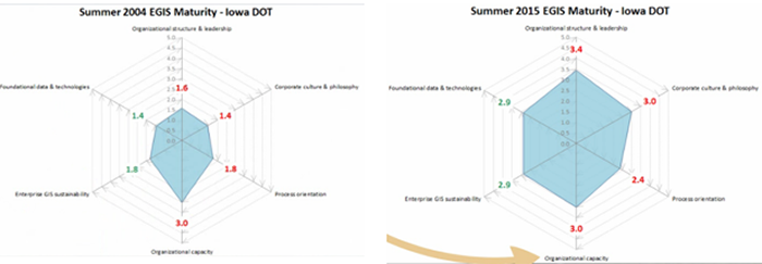
Figure 1. Comparison of Iowa DOT’s 2004 maturity model results to a 2015 maturity model
The Slimgim Maturity Model provides a standardized framework for DOTs that enables them to compare and identify best practices, and form partnerships with other DOTs. A peer group met using the Urban and Regional Information Systems Association (URISA) model at GIS-T 2017. The URISA model is very thorough, but was deemed too complex for an initial effort. The Slimgim model was a simpler framework for organizations to use, and was then modified for DOT-specific needs and use.
Slimgim-T Development
The Slimgim-T model was developed to be a streamlined program: users can simply download and start inputting their answers. The test users have submitted their completed models and average scores have been developed from them. The Slimgim-T model is comprised of five sections:
- Organizational Structure and Leadership
- Corporate Culture
- Organizational Capability
- Enterprise GIS Sustainability
- Foundational Data and Technologies
The model generates results using spider diagrams for these categories, much like other maturity models. However, an “Appetite for Change” score is also generated. This metric refers to an organization’s ability and willingness to progress in a given category, and the likelihood of the organization to do so.
FHWA is developing the Slimgim-T maturity model not only to facilitate organizational self-evaluation, but also to encourage collaboration between DOTs. It is recommended that if a DOT has a specific GIS Manager, that person should make the first attempt in using Slimgim-T. If a DOT does not have a GIS Manager, it is recommended that a group of staff members are convened to input answers together, rather than individuals providing answers on their own.
Questions & Answers
Does maturity ever have an end point? Or does it continue to move as technology changes?
It is very difficult to achieve “Optimized” level. DOTs should be assessing how technology changes and staying modern with trends.
How many DOTs are currently using Slimgim-T?
In addition to Iowa, there is a set of pilot States: Arkansas, Arizona, Utah, Washington and the Canadian Province of Manitoba. This information can be made available. More input for the model is always welcome, if the users keep in mind that it is a work-in-progress. FHWA is looking for additional trial users, and will send formal invitation to States.
Can you define the difference between “maturity” and “likelihood?”
Rating “likelihood” has been a difficult concept to implement. Likelihood is the probability that an organization will progress in a given category based on the maturity rating. For example, if a low maturity score is given for metadata, then it is unlikely that progress will be made with a business-as-usual scenario. The maturity ratings allow DOTs to see what categories they need or desire to prioritize their efforts within.
Continuous training is a necessary part for overall progress, correct?
Yes, this is exactly correct. Training is an integral part in all aspects of successfully progressing in maturity. Assessing training needs is extremely important.
Conclusion
The Slimgim Maturity Model provided a simplified platform for further development of a DOT-specific GIS maturity model. The Slimgim-T model seeks to not only rank an organization’s maturity in a given category, but also the likelihood of improvements to that maturity rank. Technology is always changing, and the danger of “no progress means moving backwards” can be avoided by organizations using the maturity model to assess blind spots and weak areas, and to remain up-to-date in new technologies.
Return to top

