FALL 2010
A Newsletter from the Federal Highway Administration
www.gis.fhwa.dot.gov
A Look at the Appalachian Development Highway System (ADHS)
This month's Q&A is with Jason Wang, Senior Transportation Specialist at the Appalachian Regional Commission (ARC), and Sang Yoo, Brad Cains, and Greg Dudding, all Research Associates at the Nick J. Rahall, II Appalachian Transportation Institute (RTI). They discuss the development of the ADHS GIS.
Upcoming Events
- Transportation Research Board (TRB) Annual Meeting
Washington, D.C.
January 23-27, 2011
- American Association of State Highway and Transportation Officials (AASHTO)
GIS for Transportation Symposium
Hershey, PA
March 28-30, 2011
See gis-t.transportation.org/
Q. What is the ARC?
A. The U.S. Congress established the ARC in the Appalachian Development Act of 1965. ARC is a regional economic development agency that represents a partnership of Federal, state, and local government agencies.
ARC is composed of the governors of the 13 states in the Appalachian region and a Federal co-chair who is appointed by the President. Multi-county local development districts provide local participation. ARC funds many types of projects, including the ADHS, which support economic development in the Appalachian region.
Q. What is the ADHS?
A. The Appalachian Development Act of 1965 established the ADHS, which was designed to promote economic development in previously isolated areas and better connect the Appalachia region to the interstate system.
The ADHS is currently authorized at 3,090 miles. Approximately 87 percent of these miles are complete or under construction. Completion of the ADHS remains a top priority for ARC.
Q. What is the ADHS GIS?
A. The ADHS GIS is an integrated, comprehensive, web-based GIS mapping system. It provides an efficient tool to allow users — the 13 Appalachian states and FHWA Division Offices from these states—to update and query ADHS information across the Appalachian region.
The ADHS GIS is unique in that it is one of the only transportation GIS systems in the nation that includes data from multiple states while supporting integrated usage by many Federal, state, and local users. The ADHS GIS is designed not only for public viewing but also for transportation system operators to support decision-making.
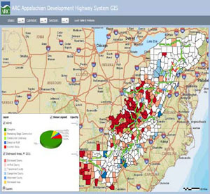
 Figure 1. ADHS GIS Silverlight application.
Information included in the system covers the Federal-aid highway program, state and county corridors and roadway sections, as well as specific projects.
Q. How was the ADHS GIS developed?
A. ARC transportation and highway program office staff initiated the ADHS GIS in 2002, in partnership with RTI. To develop the GIS, ARC and RTI created a basemap and customized it for a desktop system using ESRI ArcMap.
The most recent additions to the system use an ArcGIS Server and the Microsoft Silverlight platform. These additions, which include updating the platform technology to add functionality and improve performance and incorporating economic development data, are currently under development.
ARC and RTI now maintain the ADHS GIS in collaboration with the Departments of Transportation (DOTs) and FHWA Division Offices from all 13 Appalachian states.
Q. Who currently uses the ADHS?
A. Regular users of the system include ARC transportation staff, FHWA Division Offices in the 13 Appalachian states, FHWA's Federal-aid program administration office staff, and State DOTs in the Appalachian region.
With recently added economic development data and tools, the system has gradually added additional users such as other representatives of Appalachian states and ARC economic development staff and program managers.
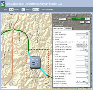
 Figure 2. Editing a ADHS corridor section in the Silverlight application.
Q. Why was the ADHS GIS chosen as a tool to support the ADHS? How is the GIS used?
A. In 2002, ARC and FHWA conducted several ADHS Cost-to-Complete Estimate (CCE) studies. The purpose of the effort was to provide a foundation for Congress to establish new Federal funding levels needed to complete the ADHS and determine the apportionment factor for completing the ADHS among the 13 Appalachian states.
The ADHS GIS technology was deployed to facilitate and complete the CCE studies. Additionally, the GIS was designed to help support ADHS program management and more effective, efficient decision-making on the development of the ADHS.
The ADHS GIS now provides a web-based, mapping, and online data management tool that allows non-GIS users at State DOTs and FHWA Division Offices to more easily complete CCE updates online. The tool minimizes the need for multiple location coordination and mitigates the impact of staff turnover or transitions.
Q. Where do you obtain data for the applications?
A. A. Data are obtained from ARC and RTI's data collection efforts, as well as from State DOTs, state data clearinghouses, ESRI, and the U.S. Census TIGER files.
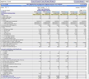
 Figure 3. ADHS Cost Estimate Table B.
Q. Are there challenges in securing funding for use of the application?
A. ARC and RTI jointly fund the ADHS GIS. The USDOT Research and Innovative Technology Administration has recognized the ADHS effort as a successful partnership between a government agency and a University Transportation Center.
Q. Are there future plans to change or modify the ADHS GIS?
A. A. ARC and RTI will continue to improve and update the ADHS GIS application based upon user input and identified needs. ARC and RTI will also make changes to prepare for the 2012 CCE studies. These changes will be identified by system users. Furthermore, ARC and RTI will look for new ways to leverage the web-based GIS to include economic development functions in Appalachia.
Ultimately, ARC and RTI intend to extend the ADHS Cost-to-Complete platform into a new GIS system that would integrate transportation and economic development data into a single web-based GIS.
To date, RTI has successfully implemented the first phase of these upgrades, creating an updated, web-based GIS for the ADHS Cost-to-Complete platform and a prototype for the transportation-economic development platform.
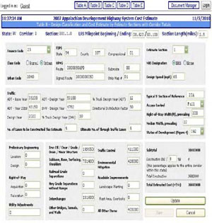
 Figure 4. Editing screenshot of ADHS Cost Estimate Table B.
Q. What are the benefits of the ADHS GIS?
A. There are several benefits derived from use of the ADHS GIS tool. From the CCE studies completed in 2007, ARC and RTI learned that the tool has led to both time- and cost-savings in updating CCE estimates throughout ARC's region. The tool has also helped connect users across the 13 Appalachian States and FHWA Division Offices through use of a single networked platform.
The GIS has allowed users who are interested in transportation and economic development in the Appalachia region, including ARC, its local partners, and Congressional staff, to access information without needing to ask State DOTs and FHWA Division Offices.
Finally, the application stores and archives ADHS-related documents and data in a repository for anyone who needs them and supports coordination among multiple agencies.
Overall, implementing the online version of the ADHS GIS has lowered the cost of updating and maintaining ADHS geospatial data, improved the flow of data exchange between agencies, and helped create a centralized, enterprise-level data repository.
Q. What have been the critical success factors or lessons learned?
A. Critical success factors include the close ARC/RTI partnership and the agencies' collaboration with the 13 Appalachian State DOTs, FHWA Division Offices, and FHWA headquarters. Exploring and adapting new technology has allowed ARC and RTI to achieve its goals and accommodate new demands from users across the region and all levels of agencies.
Why Can't We Get on One Map?
Editorial from James E. Mitchell, Ph.D., Louisiana Department of Transportation and Development (DOTD)
There has been a great deal of discussion regarding the topic of “transportation for the nation.” Ideally, a transportation for the nation effort would result in a seamless, national GIS roads database that might include other transportation features (rail, linear referencing, etc.).
There would be a number of benefits to developing a national GIS database. For example, if we were all on one map, we would get on the same geographic coordinates when we geocode a location. We could provide road mileage in a more consistent manner. We could more effectively report on highway performance management system data and reliably map them. With a single consistent schema and seamless data, we would have interstate interoperability. However, it has been difficult to determine how or where to obtain funding to support such an initiative.
In the past, there have been three separate efforts that have sought to develop a national dataset, including the U.S. Census TIGER data, TomTom (formerly Tele Atlas and Geographic Data Technology (GDT)), and NAVTEQ. All of these datasets offer consistent, standard information and “nationwide” GIS coverage.
However, as many transportation GIS professionals are aware, none of these datasets offer completely up-to-date information and this problem is exacerbated in rural areas. In addition, the TIGER data do not support routing attribution, although all three efforts support geocoding.
Regardless of their various shortcomings, the public relies on these three datasets for the ever-increasing in-car navigation market, as well as for Internet geocoding, mapping, and routing. It is important to note that the data used for in-car navigation (e.g., for address location and routing) are only as good as the last update that the user loaded onto their navigation unit.
As highways, intersections, and other transportation infrastructure are modified and updated, information becomes outdated. This issue has already caused problems in a number of states. There are examples of car crashes that have been blamed on in-car navigation devices sending drivers down a one-way road in the wrong direction.
These issues will continue until user devices can obtain real-time data from “the cloud.” I believe that the day is coming. The U.S. Census, TomTom, and NAVTEQ have made substantial investments in developing and marketing their intellectual property. In the discussion on transportation for the nation, all of these efforts have been examined and various approaches considered.
What no one has done is talk to state Departments of Transportation (DOTs) about their business requirements for statewide data. Clearly, not all states have the same requirements. For example, some State DOTs are responsible for local roads, while others are not. Some require routing while others do not.
Most State DOTs are not involved in addressing or geocoding; however, their users need these capabilities. None of the current providers directly supports linear referencing.
Most State DOTs extensively use linear referencing and have a fairly well developed GIS program. However, not all State DOTs actually map, or create GIS data, for their roads. The USDOT does not map the nation's transportation system. Most transportation-related GIS work is performed at the state agency level.
Wouldn't it be great if we could all be on one map? Wouldn't it be great if this map supported State DOTs' business processes?
For questions or more information, please contact:
James E. Mitchell, Ph.D.
Information Technology GIS Manager
Louisiana DOTD
Baton Rouge, LA 70802
http://wwwsp.dotd.la.gov/Inside_LaDOTD/Divisions/Mgmt_Finance/GIS/Pages/default.aspx
Jim.Mitchell@la.gov
(225) 379-1881
Other News
Website Update
FHWA has updated the GIS in Transportation website at www.gis.fhwa.dot.gov. The new website offers information on GIS events, industry news, and innovative GIS applications from around the country, as well as the FHWA GIS in Transportation quarterly webcasts and newsletters.
The website also includes new ways to stay in touch and informed about events through an email listserv, Twitter ‘tweets,’ and an RSS feed.
To sign up for the listserv or access the Twitter and RSS feed options, please see the “Connect” section in the lower right-hand corner of the website.
Reports
FHWA has produced several reports on uses of GIS tools and applications to support transportation decision-making. For example, a recent report (completed in March 2010) focused on transportation agencies' uses of web 2.0 technologies, including GIS mashup maps.
These reports are available at www.gis.fhwa.dot.gov. Please visit the site to learn more or to submit information about your agency's transportation GIS applications.
For More Information
For more information about this newsletter, please contact Mark Sarmiento, FHWA Office of Interstate and Border Planning, mark.sarmiento@dot.gov.