Webinar 35
Data Integration through Data Governance
February 6, 2018
Summary of the Federal Highway Administration’s Quarterly Webinar: Applications of Geospatial Technologies in Transportation
Background
Ian Kidner (Ian.Kidner@ohio.dot.gov) is the GIS Manager for the Ohio Department of Transportation (ODOT). He focuses on delivering technology solutions to improve workflows and agency efficiency. As a manager, Mr. Kidner provides leadership for asset management, data governance, LRS/Road Inventory, and GIS policy initiatives at ODOT. In addition to Bachelor’s degrees in Sociology and Geographic Information Systems, Mr. Kidner has a Master’s degree in Technology Management, and is a certified GISP. Building on his GIS and IT background and his experience at ODOT, Mr. Kidner delivered a webinar presentation on ODOT’s data governance and data integration techniques to an estimated 100 viewers. A recording of the webinar can be viewed here.
Introduction
Data governance and data integration is a complex problem to solve. Imagine there are several systems that collect information, with an end-goal of organizing their output data into one central repository so that subsequent systems can access and work. One of the initial challenges that arises in this situation is the use of different data collection standards, none of which are necessarily wrong. ODOT developed both short- and long-term strategies to deal with these complexities.
Short-Term Approach
In the short-term, ODOT first implemented the Transportation Information Management System (TIMS), a web-mapping portal that allows users to access ODOT’s geospatial information. TIMS has drastically reduced the amount of time the GIS technical staff were spending on the large volume of assistance and data processing requests from ODOT. TIMS shifts this burden of light data processing to the users themselves, and allows the GIS staff to focus on managing data from a high level, and analyzing ODOT’s overarching needs. TIMS also facilitates transparency in the data management process and empowers staff to utilize data belonging to other staff members. This freedom of information also encourages all staff members to maintain clean, high quality data-sets.
Organizational structure is a key component for implementing data governance policies. The structure of ODOT’s Asset Management Leadership Team can be seen in Figure 1 below.
Figure 1. ODOT’s Organizational Structure
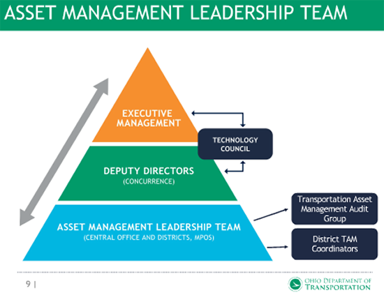
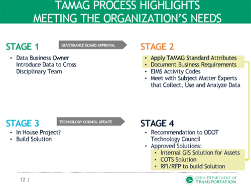
The District Transportation Asset Management (TAM) Coordinators within this structure aid in the day-to-day data governance activities. The Transportation Asset Management Audit Group (TAMAG) ensures that the data collected by ODOT is of high quality and created a work-flow shown in Figure 2 below. The cross-functional nature of this group seeks to meet the needs of ODOT as a whole, rather than serving a specific department. Coordination and consensus building is a great deal of work, but the end results are well worth the time and effort.
Figure 2. Data Collection Work Flow
TAMAG also created a Business Requirements document that shows the benefits to customers of data governance policies. A “high-quality data” inspection manual for highway operators is also in development. This manual will be utilized to communicate the importance of the end-user’s role in maintaining the quality of all data that is collected.
ODOT is also implementing new data standard attribute requirements across both old legacy systems, and all new systems going forward. A spreadsheet tracks every single piece of data, its completeness, and any issues that arise. This spreadsheet enables any member of the team to jump in and troubleshoot problems. An “inventory life cycle diagram” was created to map out each step of data processing, and can show what the problem is, in what step it is occurring, and how it can be fixed.
Esri Collector and was chosen as the main platform for ODOT’s data collection effort. Using Collector reduces the training burden on technicians, as they only have to learn one new technology language framework and utilize the numerous solutions within it. This strategy also drives data integrity and consistency. A “business progress” chart is also used to mark major milestones in development and monitor progress.
Long-Term Approach
The first step in ODOT’s long-term strategy was to make use of a custom Data Governance Maturity Assessment. Prior to conducting this maturity assessment, an Enterprise Data Study performed in 2014 indicated major problems with how ODOT was managing information, and a need for an official data governance structure. ODOT’s Secretary of Transportation fully backed this Data Governance Maturity Assessment.
Maturity assessments show how an agency is currently performing across 16 categories, plots “goal posts” where the agency would like to be, and details the path to achieving those goals. The assessment also generates a spider diagram that shows the gaps between current maturity levels and goal levels, shown below in Figure 3.
Figure 3. Diagram from ODOT’s Maturity Assessment
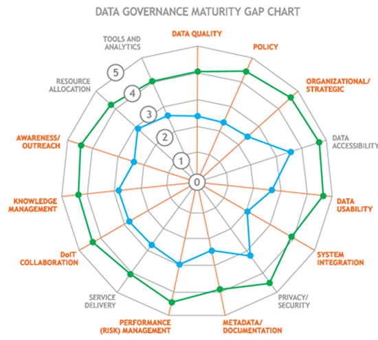
ODOT’s assessment showed that the agency was not performing well in the “Organization” and “Strategic” categories. ODOT was able to use the results to inform a list of recommendations to address these weak points. These recommendations included hiring a Chief Data Officer, establishing a data governance framework and policy, and creating a data governance oversight committee. These recommendations were further broken down into a 5-year timeline, as seen in figure 4 below.
Post-Assessment
Overall, the preceding solutions have initiated a culture change at ODOT that created an “appetite” for better solutions and high quality data. The shift towards process-oriented thinking, which is inherent within capability maturity models, greatly aids in the implementation of data governance. Once an agency has reached the “managed” level of maturity within a given category, it can begin to shift towards becoming proactive rather than reactive to issues. It is important for agencies to step through each level of maturity, rather than jumping from a low-level of maturity all the way to “managed” or “optimized;” agencies must define their systems first. This approach eases the pressure on staff and encourages them to thoroughly think and work through the issues.
A peer exchange hosted by FHWA in September 2016 on Capability Maturity Models (CMMs) showed there was great interest in this tool from attendees. However, it was found that a State DOT/GIS-specific CMM did not exist. At GIS-T 2017, Mr. Kidner presented a new pilot GIS-specific CMM. Another peer exchange was held in September 2017 and a new GIS CMM model was created, based on the Slimgim model.
The hope for this new GIS CMM is that it can be leveraged by all State DOTs for internal planning and comparisons across all State DOT programs, demonstrating successes and sharing effective strategies. There will be a workshop at GIS-T 2018 for this new GIS CMM.
Questions & Answers
Following Mr. Kidner’s presentation there was a question and answer session, which is summarized below:
What happens after ODOT’s 5-year Plan is complete?
The goal is to end up with a Data Governance Program, a permanent structure of how ODOT does business. A lot of this is to be determined, but they want a full-fledged program to meet the agency’s strategic objectives, and possibly perform annual maturity assessment to ensure performance would be utilized.
How did ODOT select the list of standard attributes?
This was based off of ODOT’s Linear Referencing System (LRS). The LRS Route ID is an intelligent code that contains metadata, and the LRS system also contains fields of data that are commonly requested and/or used for management purposes.
What was the deciding factor not to include address information in center-line data?
This was not ODOT’s full center-line information data set. The table shown in the presentation was just the key standard data items included in all of ODOT’s information systems. The data-addressing process would be an LRS function that ODOT will be able to integrate with the common data points.
What tools is ODOT using for LRS management in the office and for field data collection?
ODOT uses Esri Roads & Highways for LRS management, and a number of methods for field data collection. This includes a documentation process, where local county agencies are responsible for providing local roadway updates to the State via the Certified Mileage Program. This documentation is then digitized by ODOT. There is also the LDRS program that involves conflating the local agency data with ODOT’s common data sets.
Has ODOT created a data warehouse or a single-point of truth?
ODOT has identified a single-point of truth for all the enterprise data sets but has not created a true enterprise data warehouse. There are so many access points that they struggle with proper authority of data at times. ODOT hopes this next phase of data governance will help them integrate a true warehousing system.
What factored into ODOT’s decision to use WGS84 data format?
ODOT used WGS84 for web-mapping purposes and because a lot of collected data is already in that format.
Has ODOT’s data governance plan extended to safety or non-spatial data?
Yes. Everything ODOT does inherently has a spatial component. The spatial data is maintained by any number of people across the agency. ODOT examined all of their systems for their Data Governance Review, including safety data.
Can you outline any ways ODOT is using asset or LRS data for safety analysis?
ODOT is building a road intersection file that will be integrated with the LRS. He is not wholly familiar with safety analysis activities that ODOT’s safety engineers perform, but he knows they utilize it a lot. He encouraged Connecticut DOT to email him for further information.
Does ODOT work with local government for their LDRS?
The LDRS mentioned is a 3-year State project to create an “all-roads” network. Moving forward, collaboration with local governments will be of great importance for the collection, updating, and maintenance of data. ODOT is reviewing how to perform this task and will most likely assemble a Steering Committee with representatives from all counties in the State.
Does ODOT catalog its applications and data?
Mr. Kidner’s office is creating a GIS Application and Data Portfolio, the purpose of which is to actively track what each database or application does and align it against the specific regulatory requirement or business function. It is uncertain how ODOT as a whole does this.
How is ODOT exposing and consuming metadata?
In ODOT’s TIMS application, they have a data glossary that defines all the information that is published. Mr. Kidner’s team would like to establish more complete metadata standards but they have yet to do that. He believes this will be part of the next phase of the Data Governance Plan.
Conclusion
ODOT stresses that the “Three Elements of Success” (People, Processes, and Technology) are much more effective than a single “silver bullet” approach to data governance. Agencies must prioritize having the right people and processes in place before implementing new technologies. Mr. Kidner expressed that he is happy to answer any further questions via email.

