A Newsletter from the Federal Highway Administration (FHWA)
www.gis.fhwa.dot.gov
Spring 2017
Using Aerial LiDAR Technology to Update Highway Feature Inventory
Utah Department of Transportation
Upcoming Events
- Capability Maturity Model Peer Exchange: Following up on last year's successful peer exchange, Ohio DOT will host a CMM Peer Exchange on September 19th and 20th of this year.
- The National States Geographic Information Council will host its Annual Conference from Monday, September 25th to Friday, September 29th in Providence, Rhode Island. For more information, please visit the NSGIC website.
Since 2012, the Utah Department of Transportation (UDOT) has started using mobile LiDAR data and airborne mapping to provide effective information about road assets. The FHWA GIS in Transportation Program interviewed State DOT's Research Project Manager, Jason Richins, on one of their GIS initiatives; the LiDAR-based Maintenance Feature Inventory.
What transportation needs existed at your agency? How did the use of the application/geospatial technologies address these needs? How do people use the application/geospatial technology?
UDOT's Maintenance Feature Inventory, housed inside the Operations Management System (OMS), was largely populated as a result of a Mobile LiDAR (Light Detection and Ranging) data collection effort conducted by Mandli Communications in 2012.
Why was the application/geospatial technologies chosen as tools to meet these transportation needs?
The Feature Inventory, however, is not static, so it is imperative to identify cost-effective means to keep the data current. Currently, Mandli helps UDOT conduct a new Mobile LiDAR data collection every two years to identify differences in the asset inventory. However, a more cost-effective means of identifying differences may be by employing Aerial LiDAR in areas where large-scale changes may have occurred, such as where new construction activities may have occurred subsequent to the original data collection. Aerial LiDAR technology offers the advantages of a) less time spent in data collection (days rather than months), and b) a view of the roadway from a different perspective, allowing features to be viewed and identified that may have been hidden from the Mobile platform.
How do people use the application/geospatial technologies to meet transportation needs? Who currently uses the application/geospatial technologies?
The main goal of the project was to analyze and demonstrate the feasibility of the airborne LiDAR inventory technique for collecting and recording highway inventory data. The project is an exploratory research project. Proving that data collected through airborne mapping can provide effective information about road assets will help state DOTs and transportation agencies save large amounts of resources on road inventory in the future.
Application and Data Development
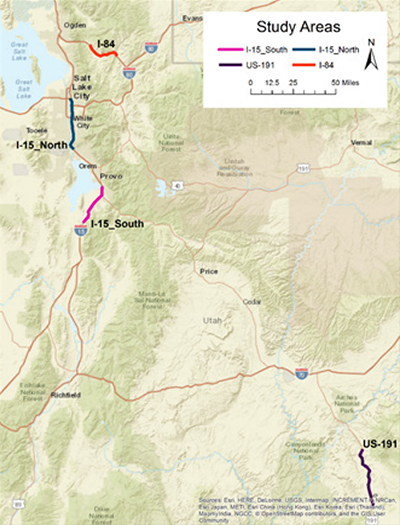
Figure 1. UDOT LiDAR Study Areas
Who initiated the application of the application/geospatial technologies to meet transportation needs? Who brought it to completion? How many people were involved in the process? When?
Lloyd Neeley and Rukhsana Lindsey were the UDOT champion of the project. The project titled “Implementation of Aerial LiDAR Technology to Update Highway Feature Inventory” was contracted to a research team at Utah State University, led by Dr. Ziqi Song, in 2015. The research team consists of 7 people.
What other factors contributed to use of this application/geospatial technologies in this way?
Despite LiDAR becoming increasingly popular across the United States, and state DOTs and transportation agencies adopting LiDAR technology to deal with transportation-related applications, to date, airborne LiDAR is still not as popular as other inventory techniques because of its expensive initial investment and limitations in identifying small objects. The main purpose of this research is to analyze the advantages and disadvantages of airborne LiDAR technology in collecting and recording highway assets.
Where do you obtain data for the application/geospatial technologies?
The field experiments were conducted by the research team at USU. Prior to data acquisition the flight lines were planned and stored in the onboard GPS system to be followed during the actual flight. The flight campaign was conducted on June 4, 2015, and can be divided into two separate parts. The first part was from 11:20 am to 12:45 pm and covered three road sections: I-84, I-15 North, and I-15 South. The second part was from 3:20 pm to 4:20 pm and mapped section US-191. The weather conditions were a partially cloudy sky and a clear sky during the first and second parts of the flight, respectively.
Each section of the roads of interests was divided into multiple subsections with each covered by a single flight line. The data acquisition includes LiDAR and colored high resolution images. This study covers four road sections in Utah (see Figure 1), one on Interstate 84 (I-84), two on Interstate 15 (I-15), and one on US-191 (Figures 4.3-4.4). The exact location of these sites can be described by the distance between two mileposts (MP) as follows:
- I-84 from Mountain Green to Morgan County/Summit County (MP 97 to 113)
- I-15 North from Lehi to Salt Lake City (MP 284 to 307)
- I-15 South from Santaquin to Springville (MP 241 to 260)
- US-191 from MP 84 to 112 (MP 84 to 112)
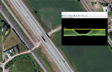
Figure 2a. UDOT LiDAR Imagery (1)
How has the use of the application/geospatial technologies met the transportation, business, and/or technical needs of your agency or department? How do you know?
State DOTs and transportation agencies are always looking for better techniques to reduce costs. Airborne LiDAR is much faster in data collection than conventional surveying methods. This project further demonstrated that the point density of airborne LiDAR data is sufficient for most highway assets. Also, airborne LiDAR has the advantage over ground-based inventory technologies of providing a different perspective; as a result, it can detect objects like bridges and culverts that may be hidden from the mobile platform (see Figures 2a and 2b). In addition, the data processing procedure proposed in this project improved the efficiency of airborne LiDAR. We conclude that airborne LiDAR is a highly promising technique that can serve as a complement to other techniques for highway inventory data collection.
Are there future plans to change or modify this application or how geospatial technologies are used? If so, how and why?
UDOT will start the second phase of the project titled “A Data Fusion Approach for Extracting Highway Maintenance Features” in the summer of 2017.
Most studies investigating highway feature extraction in the literature focus on a single source of data, e.g., aerial LiDAR or imagery data. The research team found that each data collection method has its advantages and limitations. The most effective approach to achieve the maximum level of accuracy and completeness is probably to combine data collected from multiple sources.
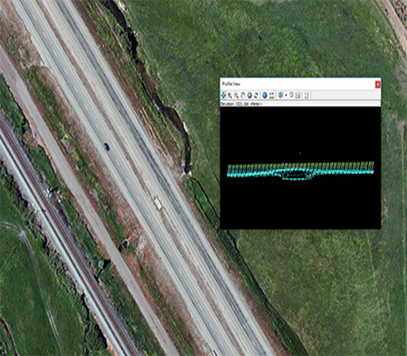
Figure 2b. UDOT LiDAR Imagery (2)
Geo-referenced high-resolution aerial imagery data can be used as an alternative means to identify highway features. With the advent of Unmanned Aerial Vehicle (UAV) technology, high-resolution aerial images will be much more affordable and easily accessible for transportation agencies in the future. However, aerial imagery data do not contain any elevation information, which is critical for identifying some highway features. To achieve the maximum level of accuracy and completeness, it is imperative to develop a data fusion approach that utilizes both aerial LiDAR and aerial imagery data to compensate for the limitations of both methods. Also, automated feature extraction is an important aspect of large scale applications. As a result, the second phase of the project will take advantage of the unique data set, which contains both aerial LiDAR point cloud and high-resolution aerial imagery data, obtained from the phase 1 study by developing an efficient workflow for automatic extraction of highway maintenance features.
What have been the critical success factors or lessons learned while applying the application/geospatial technologies to meet transportation needs?
Because of the sparseness of the airborne LiDAR points, smaller highway features, such as speed limit signs, are difficult to be identified accurately by aerial LiDAR data. However, all other assets included in the Mandli dataset were successfully explored. Moreover, we were able to detect bridges and culverts that cannot be mapped from the mobile platform because of the broad view and different perspective of the aircraft. As shown in Figures 2a and 2b, bridges (a) and culverts (b) are distinctive in airborne LiDAR data.
GeoWomen Invites Your Participation
Editorial by Molly Schar, Executive Director of National States Geographic Information Council
GeoWomen, the group started by the National States Geographic Information Council (NSGIC) a few months ago, has a new home. NSGIC recently launched a new website that serves as a communication platform for members and stakeholders around the world. GeoWomen can be found there.

Figure 3. First GeoWomen Meeting in 2016
While initially envisioned as a women's group that would caucus during NSGIC's two conferences each year, GeoWomen quickly grew to include a vision for attracting more women to GIS careers, nurturing women emerging leaders, and expanding the involvement of women as volunteer leaders on the U.S. national stage through NSGIC.
At its first official meeting in early March, GeoWomen identified a short-term goal of creating a national network of GIS women's groups, including local user groups as well as social media-based groups. Through a “limited access account” on NSGIC's new website (nsgic.org), individuals interested in joining GeoWomen can sign up and start to interact with other GeoWomen participants.
The GeoWomen initiative will leverage NSGIC's network of state government chief geospatial officers and coordinators, as well as federal agency partners and private industry sponsors.
As momentum builds, the group hopes to establish a list of GIS internship opportunities, and begin outreach to university and K-12 schools.
To learn more and to join the GeoWomen group, please visit www.nsgic.org/let-s-rally-for-geowomen-.
Other News
Now Available: 2016 Organization Assessments Peer Exchange Summary Report
In September of 2016, seven State DOTs and FHWA met to discuss current challenges to carrying out GIS organizational assessment. A summary of each State's experience, lessons learned and recommendations is available at https://www.gis.fhwa.dot.gov/reports/Capability_Maturity_Model_Peer_Exchange.aspx
Now Available: URISA GIS Capability Maturity Model (CMM) Webcast Summary
Allen Ibaugh, CEO of Data Transfer Solutions (DTS) and member of URISA presented an overview of what a GIS CMM is and how GIS has grown to become a ubiquitous tool across many disciplines such as government, private industry, agriculture, and academia. The webcast recording and summary are available at https://www.gis.fhwa.dot.gov/webinars/webinar31_Applications_of_Geospatial_Technologies_in_Transportation.aspx.
Now Available: How LA Metro Leverages Waze Data to Manage Traffic
Kali Fogel, Program Manager from the Los Angeles County Metropolitan Transportation Authority (Metro), presented a detailed slideshow on RIITS and the integration and potential uses of the Connected Citizens Program. The webcast recording and summary are available at https://www.gis.fhwa.dot.gov/webinars/webinar32_LAMetro_Waze.aspx.
Available Now: Mobile LiDAR - Uses at Oregon DOT
Chris Glantz, Lead Remote Sensing Surveyor at Oregon DOT, reviewed the science and application of LiDAR technology in transportation. Mr. Glantz also presented examples of how Oregon DOT has utilized the technology to address State transportation needs across fields such as safety and asset management. The webinar recording and summary are available at https://www.gis.fhwa.dot.gov/webinars/webinar33_Uses_of_Mobile_LiDAR_at_ODOT.aspx.
Upcoming: Capability Maturity Model Peer Exchange
Following up on last year's successful peer exchange, Ohio DOT will host a CMM Peer Exchange on September 19th and 20th of this year. If you or someone from your agency is interested in participating, please reach out to Mark Sarmiento at FHWA: Mark.Sarmiento@dot.gov
Advisory Panel
FHWA and the U.S. DOT Volpe Center are soliciting interest from GIS practitioners in serving on an advisory panel for the FHWA GIS in Transportation program. This panel would serve to 1) guide the identification of research priorities, 2) identify communications needs for stakeholders, and 3) provide recommendations to ensure that the program's activities and products align to stakeholder needs. If you are interested in participating or have further questions, please contact Mark.Sarmiento@dot.gov, FHWA Office of Planning.


