A Newsletter from the Federal Highway Administration (FHWA)
www.gis.fhwa.dot.gov
WINTER 2014
A Look at Washington Department of Transportation's Community Planning Portal
This month's Q&A is with Kyle Miller and Julie Fogde of the Washington State Department of Transportation (WSDOT). They discuss WSDOT's development and use of the Community Planning Portal.
Upcoming Events
- AASHTO GIS for Transportation Symposium
May 5-8, 2014
Burlington, VT
- Esri International User Conference
July 14-18, 2014
San Diego, CA
- COM.Geo 2014 & COM.BigData 2014
August 4-6, 2014
Washington, DC
- URISA's GIS-Pro 2014: Leveraging Spatial Technology to Support Sustainable and Resilient Communities
Sept. 8-11, 2014
New Orleans, LA
What transportation data needs existed at WSDOT, and how did you address these needs?
Washington State's Growth Management Act requires local governments to periodically review and update their comprehensive plan. Transportation is one of the main components of a comprehensive plan and is an effective tool for shaping the community's future development patterns.
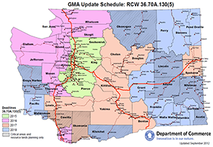 The Community Planning Portal was developed to help jurisdictions meet the requirements of the Growth Management Act.
Prior to the development of the Portal, local planners had to refer to multiple sources to get the state transportation data that they needed to develop a plan. The goal of the Portal is to bring together all of these separate data sources and make them available via a publically accessible, free, and easy to use map application called the Community Planning Portal.
The Portal is a browser-based, interactive web map application built using ESRI's ArcGIS Online technology. Users can turn data layers on and off, search for and add spatial data layers from other organizations, click on a feature to get more information, access feature metadata, print a map, and access custom-built city and county factsheets. The Portal allows local agencies to view and interact with data in a way that—until the development of the Portal—required expensive GIS software and significant technical expertise.
Why did WSDOT select this technology to meet the state's transportation planning data needs?
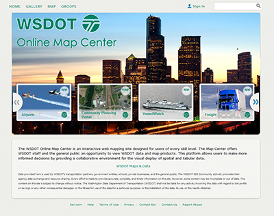 The Community Planning Portal is located within the WSDOT Online Map Center.
WSDOT selected ArcGIS Online as the platform for the Portal because it enabled the agency to leverage its existing map services and distribute them to a much broader audience. This technology cost less to develop and required less maintenance than other mapping solutions, provides easy access to a wide array of WSDOT data quickly and transparently, and allows the user to combine WSDOT data with outside data sources in a single map. These maps are dynamic and easily shared with select groups or publically with just a few clicks of a mouse. Since the Portal is browser-based, it can be accessed by anyone, anytime, anywhere and does not require special software, training, or advanced GIS skills to operate.
How is the Community Planning Portal used, and who uses it?
The Portal is a simple web map that has been populated with transportation-specific content. Anyone who needs to know more about WSDOT's current state transportation system can simply turn on data layers he or she are interested in and click on the features displayed in the map to get more information. If users want to conduct a more in-depth analysis or make a more sophisticated map, they can use the Portal to download the source data into their existing GIS system.
The Portal was originally developed to be used by local and regional planners. However, as use of the Portal has grown and word has spread, it has not only become a gateway to discover WSDOT data, but a way to start conversations about how to make public data more readily accessible to the general public.
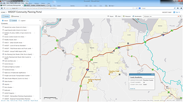 The Community Planning Portal helps local, regional, and state planners collaborate more effectively.
How was the Community Planning Portal developed?
In early 2013, the WSDOT Community Transportation Planning Office approached the WSDOT Transportation Data and GIS Office about developing an interactive mapping application that would allow local agencies to view WSDOT spatial data. Over the next year, a team of six staff worked part time to define the project requirements, develop data sources, coordinate with data stewards, and test and promote the tool. It took the project team approximately eight months to develop the first phase of the Portal.
What other factors contributed to the use of this technology for the Portal?
Prior to the Portal project, WSDOT had invested considerable resources in developing an ArcGIS Server environment to support custom map applications. This investment included a 50-user subscription to ArcGIS Online. WSDOT was also one of the first state DOTs to be invited to join the American Association of State Highway and Transportation Officials (AASHTO) Technology Implementation Group (TIG) UPLAN project, which also uses ArcGIS Online. Executive interest in using this readily available technology resulted in a compelling case to move the project forward.
How did WSDOT fund the development of the Portal?
The initial funding commitment to develop the content in the Portal was relatively small (approximately $20,000). This relatively minimal entry level cost was possible because the work was completed in-house; because the AASHTO TIG covered some of the start-up costs associated with ArcGIS Online; and because the Portal focused largely on leveraging existing WSDOT resources. Because of these factors, the cost to maintain the tool is also minimal.
Where does WSDOT obtain data for the Portal?
With very few exceptions, the data layers presented in the Portal are authorized and stewarded by WSDOT. They are publically available for download from the WSDOT GeoData Distribution Catalog.
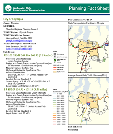 City/County Planning Fact Sheets provide a quick overview of transportation facilities within a jurisdiction.
Does WSDOT plan to update the Portal in the future?
The Portal currently has more than 25 layers. Based on user feedback, WSDOT is working on adding more. Potential new layers include: fish passage barriers, noise wall locations, right of way information, stormwater discharge locations, climate change vulnerability assessments, environmental and traffic study information, commute trip reduction sites, transit stop locations/bus routes, electric vehicle charging station locations, bridge and pavement conditions, and a tribal factsheet.
What have been the critical success factors in using the Portal to meet WSDOT's transportation planning data needs?
The key to the success of this tool has been in the intra- and inter-agency coordination and promotion conducted by the Community Transportation Planning Office. Representatives from many different business areas (including local agencies) were involved in developing project requirements and providing feedback on the tool throughout the development phase.
By involving the end user in all phases of the project, WSDOT has been able to create a tool that most effectively meets the needs of its users.
For more information, please contact:
Kyle Miller
MilleKy@wsdot.wa.gov
360-705-7946
Julie Fogde
FogdeJ@wsdot.wa.gov
360-596-8919
Nevada Department of Transportation's (NDOT) Planning and Needs System
Editorial from Rebecca Kapuler, NDOT
The Nevada Department of Transportation's (NDOT) is replacing its current Project Tracking System database with a new system called Planning And Needs System (PLANS). The objective of this multi-phased project is to create a system which will enable NDOT and its external partners to more efficiently plan and report on transportation system projects. The final system will allow NDOT to create and electronically submit the Statewide Transportation Improvement Projects (e-STIP) report to the FHWA and the Annual Work Program (AWP) report.
This integrated e-STIP component of the PLANS system will include the development of an interactive GIS web-based mapping component, both for internal and external use. Needs and projects will be entered into and viewed both from the GIS map and from a data view. NDOT will use the GIS system to build projects through this planning tool. For example, individuals will be able to click on an interactive map to identify potential project boundaries. All of the needs, or deficiencies, will be displayed on a pop-up menu which will be used in building project scenarios to assist with bundling projects.
Later phases of the project will allow users to track individual transportation system needs and will create a systematic, work-flow approach to analyzing and building projects. The system will enable better project coordination, integration of data, and remove duplication of data entry. PLANS will ultimately change and improve NDOT's business processes and create an environment of efficiency and accountability, both to our external partners, (MPOs, FHWA, local governments and the public) and throughout the State of Nevada.
For more information, please contact:
Rebecca Kapuler
RKapuler@dot.state.nv.us
775-888-7122
Other News
Geospatial Data Collaboration (GDC)
GDC is a FHWA geospatial data-sharing initiative which encourages transportation agencies to use geospatial tools to share data, increase collaboration, and improve the quality and speed of transportation decision-making. GDC is one element of FHWA's Every Day Counts initiative, which is aimed at producing innovations, resources, and partnerships to shorten project delivery, enhance safety, and protect the environment.
FHWA is holding two peer exchanges this spring at which GIS practitioners will gather to share and learn about effective GDC practices. Lessons learned at the peer exchange will be summarized in a report which FHWA will publish later this year. For more information on GDC, please visit www.gis.fhwa.dot.gov/gdc.aspx.
New Reports Now Available
Two FHWA case study reports for GIS practitioners are now available online:
- Applications for the Interoperability of CAD (Computer-Aided Design) and Geographic Information Systems (GIS)
- Uses of Cloud Technologies for Geospatial Applications
These reports contain summaries of the state of the practice and lessons learned based on peer exchange discussions and case study interviews conducted with each participating organization. These reports are available at www.gis.fhwa.dot.gov/reports.aspx.
For more information about this newsletter, please contact Mark Sarmiento, FHWA Office of Planning, at Mark.Sarmiento@dot.gov.


