GIS and E911/NG911 Peer Exchange
Summary Report
June 21, 23, and 30, 2022
Host Agency: Federal Highway Administration (FHWA), via Zoom

Participating Peer Agencies
Alabama Department of Transportation
Alabama 911 Board
Arizona Department of Transportation
Arizona Department of Administration 911 Program
Florida Department of Transportation
Idaho Transportation Department
Ohio Department of Transportation
Ohio 911 Program Office
Oregon Department of Transportation
Pennsylvania Department of Transportation
Sponsoring Agency: Federal Highway Administration (FHWA)
| REPORT DOCUMENTATION PAGE |
Form Approved
OMB No. 0704-0188
|
| Public reporting burden for this collection of information is estimated to average 1 hour per response, including the time for reviewing instructions, searching existing data sources, gathering and maintaining the data needed, and completing and reviewing this collection of information. Send comments regarding this burden estimate or any other aspect of this collection of information, including suggestions for reducing this burden to Department of Defense, Washington Headquarters Services, Directorate for Information Operations and Reports (0704-0188), 1215 Jefferson Davis Highway, Suite 1204, Arlington, VA 22202-4302. Respondents should be aware that notwithstanding any other provision of law, no person shall be subject to any penalty for failing to comply with a collection of information if it does not display a currently valid OMB control number. PLEASE DO NOT RETURN YOUR FORM TO THE ABOVE ADDRESS. |
1. REPORT DATE
March 24, 2023 |
2. REPORT TYPE
Final Report |
3. DATES COVERED
June 2022 |
4. TITLE AND SUBTITLE
GIS and E911/NG911 Peer Exchange Summary Report |
5a. CONTRACT NUMBER |
| 5b. GRANT NUMBER |
| 5c. PROGRAM ELEMENT NUMBER |
6. AUTHOR(S)
Sara Secunda |
5d. PROJECT NUMBER
HW2LA621 |
5e. TASK NUMBER
WP067 |
| 5f. WORK UNIT NUMBER |
7. PERFORMING ORGANIZATION NAME(S) AND ADDRESS(ES)
U.S. Department of Transportation
John A. Volpe National Transportation Systems Center
55 Broadway
Cambridge, MA 02142-1093
|
8. PERFORMING ORGANIZATION REPORT NUMBER
DOT-VNTSC-FHWA-23-07 |
9. SPONSORING/MONITORING AGENCY NAME(S) AND ADDRESS(ES)
U.S. Department of Transportation
Federal Highway Administration
1200 New Jersey Avenue, SE
Washington, DC 20590 |
10. SPONSOR/MONITOR’S ACRONYM(S)
FHWA |
| 11. SPONSOR/MONITOR’S REPORT NUMBER(S) |
12. DISTRIBUTION/AVAILABILITY STATEMENT
This document is available to the public on the FHWA website at https://www.gis.fhwa.dot.gov/.
|
| 13. SUPPLEMENTARY NOTES |
14. ABSTRACT
The Federal Highway Administration’s (FHWA) Geographic Information System (GIS) in Transportation program sponsored a three-day virtual peer exchange in June 2022 to bring together practitioners of GIS applications to discuss and learn about how State Departments of Transportation (DOTs) and E911 agencies are building and managing their road networks and how DOT and E911 agencies can collaborate to have one road network for the State. |
15. SUBJECT TERMS
Geographic Information Systems (GIS), E911, NG911, Peer Exchange, National Address Database, road network |
16. SECURITY CLASSIFICATION OF:
|
17. LIMITATION OF ABSTRACT
Unlimited |
18. NUMBER OF PAGES
20 |
19a. NAME OF RESPONSIBLE PERSON
Sara Secunda |
a. REPORT
|
b. ABSTRACT
|
c. THIS PAGE
|
19b. TELEPHONE NUMBER (include area code)
617-494-3601 |
Standard Form 298 (Rev. 8-98)
Prescribed by ANSI Std. Z39.18
Contents
List of Figures
Figure 1. AZ data supply chain workflow (Arizona Department of Administration)
Figure 2. The Ohio Location Based Response System (LBRS), Ohio DOT
Figure 3. PA NG911 GIS Data Hub onboarding and QC pre-check status, PEMA (current as of 5/25/2022)
Figure 4. AEGIS Pooled Fund – road comparison to assign road ratings, PennDOT, AEGIST 2022
Figure 5. ECD GIS data on-boarding status, Alabama E911 Board, 06/2022
Figure 6. National Address Database schema, NENA standards
Figure 7. National Address Database, map of the status of State submissions, May 2022
Figure 8. National 911 program timeline, 2022
Figure 9. Applications of Enterprise GIS in Transportation (AEGIST) Pool Fund Program, NSGIC
Figure 10. Road information modeling rules comparison, AEGIST, FHWA Office of Planning and Safety
Purpose
The Federal Highway Administration’s (FHWA) Geographic Information System (GIS) in Transportation program sponsored a three-day virtual peer exchange in June 2022 to bring together practitioners of GIS applications to discuss and learn about how State Departments of Transportation (DOTs) and E911 agencies are building and managing their road networks and how DOT and E911 agencies can collaborate to have one road network for the State.
Peer agencies included the Alabama Department of Transportation and Alabama 911 Board, Arizona Department of Transportation and Arizona Department of Administration 911 Program, Florida Department of Transportation, Idaho Transportation Department, Ohio Department of Transportation and Ohio 911 Program Office, Oregon Department of Transportation, and Pennsylvania Department of Transportation.
FHWA hosted this virtual peer exchange via Zoom in three-day, three-hour sessions, included a series of presentations from all the peer agencies, as well as presentations on the National Address Database (NAD), Applications of Enterprise GIS in Transportation (AEGIST), and the National 911 Program. Each day of the peer exchange also featured a roundtable discussion. The exchange concluded with a discussion of next steps that FHWA can take to inform and assist State DOTs in creating and advancing data dashboards as internal and external resources. To help manage and highlight the overall effort, FHWA asked the United States DOT (USDOT) John A. Volpe National Transportation Systems Center (Volpe Center) to develop a report that provides a summary of the peer exchange, background and summaries of each presentation, themes, roundtable discussions, and next steps for participants.
Back to Top
Background
FHWA initially recognized the need for a peer exchange based on interest from State DOTs through the GIS for Transportation (GIS-T) 2019 Survey administered by the American Association of State Highway and Transportation Officials (AASHTO). Through the same AASHTO survey, the GIS-T team identified several State agencies that have experience working with their partners in moving toward one spatial representation of the roads in their State.
Participants expressed the need to share information among peers on the current state of practices and projects undertaken to create one State road network used by the State DOT and 911 agencies, to facilitate communication and cooperation among the agencies, and to learn about current NG911 projects. With that goal in mind, the Volpe Center and FHWA reached out to appropriate stakeholders in the field and invited them to participate in this peer exchange.
Back to Top
Day One Activities
Roundtable #1 - Introductions
Roundtable #1 involved each participant introducing themselves and explaining what they are interested in learning from the E911/NG911 Peer Exchange. The roundtable also reviewed the questions and answers from a pre-Peer Exchange Survey. Participants and their State, agency, and title are listed in Appendix B.
Arizona Department of Administration: Arizona’s Data Supply Chain
In the past year, the State of Arizona has begun implementing Next Generation 911 (NG911) with Geospatial Call Routing. GIS is the backbone of NG911 for emergency call routing and the overall process, so the work that is being done includes improving the geospatial data’s core datasets of address points, road centerlines, and various emergency service boundaries. The initiative involves close coordination with all their partners including State, Tribal, and county agencies as well as local municipalities, all of whom maintain their own geospatial data. In order to back up and support the initiative when working with the local partners, the State statute was first updated with the correct geospatial terminology and requirements. The State 911 continually works toward better collaboration with their local partners through education, documenting, and discussion to emphasis the value of the work. Good communication and collaboration have helped to ensure greater transparency, data quality and integration, and that the GIS data is being updated frequently to the point of discrepancies being resolved within three business days.
To update the GIS data in a timely manner and maintain the database, the State developed an automated workflow that leverages 1Spatial technology. The database is maintained in the 911 office and the workflow developed is called the AZ Data Supply Chain Strategy (see Figure 1). The main purpose is to create one authoritative, accurate data source. To do this, the Data Supply Chain leverages the existing data infrastructure. The workflow begins with local GIS data updates on the existing data that are then validated and aggregated in a self-service portal. After validation, a high-level report of the data’s quality is sent to the local authorities who are then able to use it to present to their leadership. The system tracks all steps in the process, including data edits, comments, and identifying who made the entries. The Data Supply Chain is maintained in the secure AZGeo, an ESRI product, which is also a statewide clearinghouse for all Arizona authoritative geospatial data. Within AZGeo the data can be updated and consumed by other web applications through ArcGIS Online hosted web services.
The road network uses the National Emergency Number Association (NENA) data model for road data with some additional attribution for the State’s linear referencing system (LRS) system. There are several issues that the new tools help to solve. One issue with bringing all the data together is joining the centerlines at the county boundaries. This is necessary for connectivity of the data for routeability. To do this, demarcation points are used at the boundaries, and the centerlines are snapped together. This is done by an automated process in the background using 1Spatial tools. One advantage of using these tools is that only the data changed is consumed. Another issue is how to maintain LRS from one county to another.
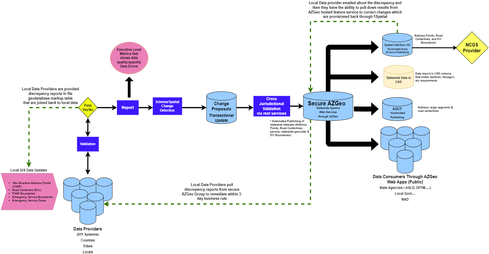
Figure 1. AZ data supply chain workflow (Arizona Department of Administration).
The AZ NG911 geodata and workflow supports several business initiatives beside NG911, including All Road Network of Linear Reference Data (ARNOLD), National Address Database (NAD), Statewide Geocoder, and Road Map with parcels. The successes of the program have been to create a standard workflow, improve data quality, provide crowdsourcing to improve data accuracy, offer support for other business cases, receive funding to support the initiative, and save lives. The Arizona Geographic Information Council has also been pushing for private partnerships with both Amazon and Google who would like to make sure their data is accurate. Arizona can use these partnerships to cross validate and reference the data ensuring information they are disseminating to various entities is correct. The State is also working on areas of improvement, such as supporting underserved and rural communities, increasing and supporting Tribal engagement, and creating a better mechanism for public/private partnerships.
The most important lessons learned with this initiative are that partnership, coordination, and communication are essential as well as having a plan. Emphasizing return on investment is also crucial to building these partnerships as well as how the program is supporting initiatives beyond 911.
Ohio DOT: Ohio 911 Program Office: Ohio Next Generation 911
Ohio DOT is currently developing the Location Based Response System (LBRS), a county/State partnership creating location road and address data information. The project began in 2004 with all parties first agreeing to the standards that need to be followed. To collect the data some counties have hired outside companies to drive their roads. For addresses, some counties have rooftop addresses and some use road centerlines, but all data formats ae accepted. The counties are also required to provide yearly updates of their road data through a License Tag Reference Program that provides funds to the counties. Once ODOT receives a county’s data, a quality check is completed and the data is then conflated with the ODOT Road Inventory System which follows the NENA standard. The conflation involves removing the existing line work and replacing it with the updated county line work. Once in the Road Inventory System, the centerline and address will become publicly available. ODOT is in the process of collecting the road data from all 88 counties in Ohio and expects the LBRS work to be completed in 2023 (see Figure 2). Once it is completed the State will work with the counties to convert their LBRS data to the NENA standard as well.
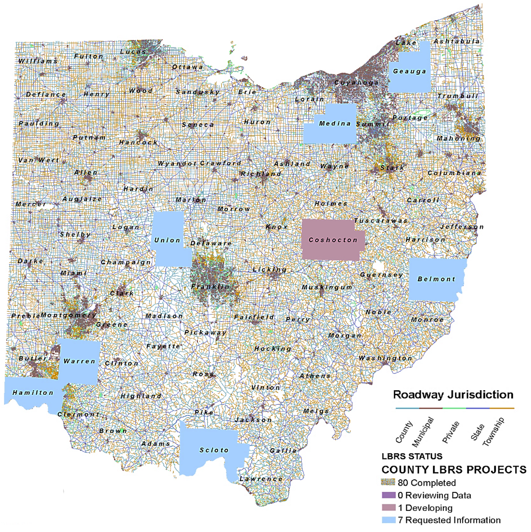
Figure 2. The Ohio Location Based Response System (LBRS), Ohio DOT.
Long Description
The LBRS initiative improves 911 disaster planning, responses, helps save lives, reduces redundant data collection efforts to save taxpayer dollars, supports Federal reporting requirements (ARNOLD, HPMS), and supports Federal planning. In addition, it brings higher reliability and network efficiency, which is used by many different agencies for various reasons, including roadway inventory, crash analysis, NG911, and census enumeration within NG911 GIS core services.
The NG911 initiative was begun in the State which has some legacy systems. There is currently an NG911 Pilot Project with six counties that uses core services that it has been running for three years. Creation of a statewide NG911 system is contingent on legislation and funding. The legislation is current in the State House waiting to be approved, and the legislation includes providing funding for State and local systems. The NG911 systems will use the GIS data to pre-validate caller location by address or latitude/longitude rather than telephone number and route the call to the correct public safety answering point (PSAP) based on the GIS location. The NG911 system will use the ODOT GIS data to fill in the NG911 data. Almost all 88 counties have at least the initial LBRS data. The data does not exactly match the I3 standard for NG911 so some of the data may have to be brought to the I3 standard, but the necessary data is available. The State owns the NG911 system and the NG911 data is shareable among all 911 operators at the State and county level.
Day One Questions and Summary
A discussion on geocoding brought up the issue of using the U.S. Postal Service (USPS) postal code, which is an optional attribute in the NENA standards. States responded that they did not yet use the official postal code which was not readily available from the postal server. Instead, geocoders were built using addresses from different sources. For example, Ohio uses a combination of mostly rooftop addresses, but also uses the parcel centroid and road centerline address points. Each address is coded so there is an accuracy value associated with the address for geocoding. In Minnesota addresses are required to be located on both the left and right sides of a roadway. The NAD is working with the USPS to acquire the postal codes.
The first day was to establish expectations for the peer exchange and start to look at how the work is done in some States. The presentations were to show how a State works with their NG911 agency and local partners to develop their databases. Two takeaways from the day include:
- Collaboration taking place between the partners is essential. Some had some structure in place already such as in Arizona with AZGeo tools and Ohio with collaboration to create an LBRS statewide centerline dataset. It also helps to have legislation in place.
- Marketing the work to all the different partners and State officials is also very important. It helps people understand the benefits of the work.
Back to Top
Day Two Activities
Presentations by Peer States
Pennsylvania DOT/E911
In the State of Pennsylvania, the Pennsylvania Emergency Management Agency (PEMA) coordinates all NG911 spatial call routing efforts and is the GIS data hub for NG911. The State’s 67 counties collect and own the data for their roads, and they each operate differently and independently. Traditionally, the counties can sell and license their data, so they have not wanted to share their data with public agencies, but NG911 State legislation now requires them to share the data with PEMA. The State’s GEO Board has facilitated a statewide data-sharing agreement which eliminates any licensing agreements. They also have an initiative called Base Map 2030 where key datasets are using the same geometry, such as roads and boundaries.
Most counties in the State have now provided their data to PEMA. (See Figure 3) The five-step process involved PEMA providing ortho imagery for the counties to use to update their geometry. Once updated, the road and address data are sent to PEMA for validation. The data is then merged into the NG911 dataset and sent back to the counties and the PSAP. PEMA also provides funding to the counties.
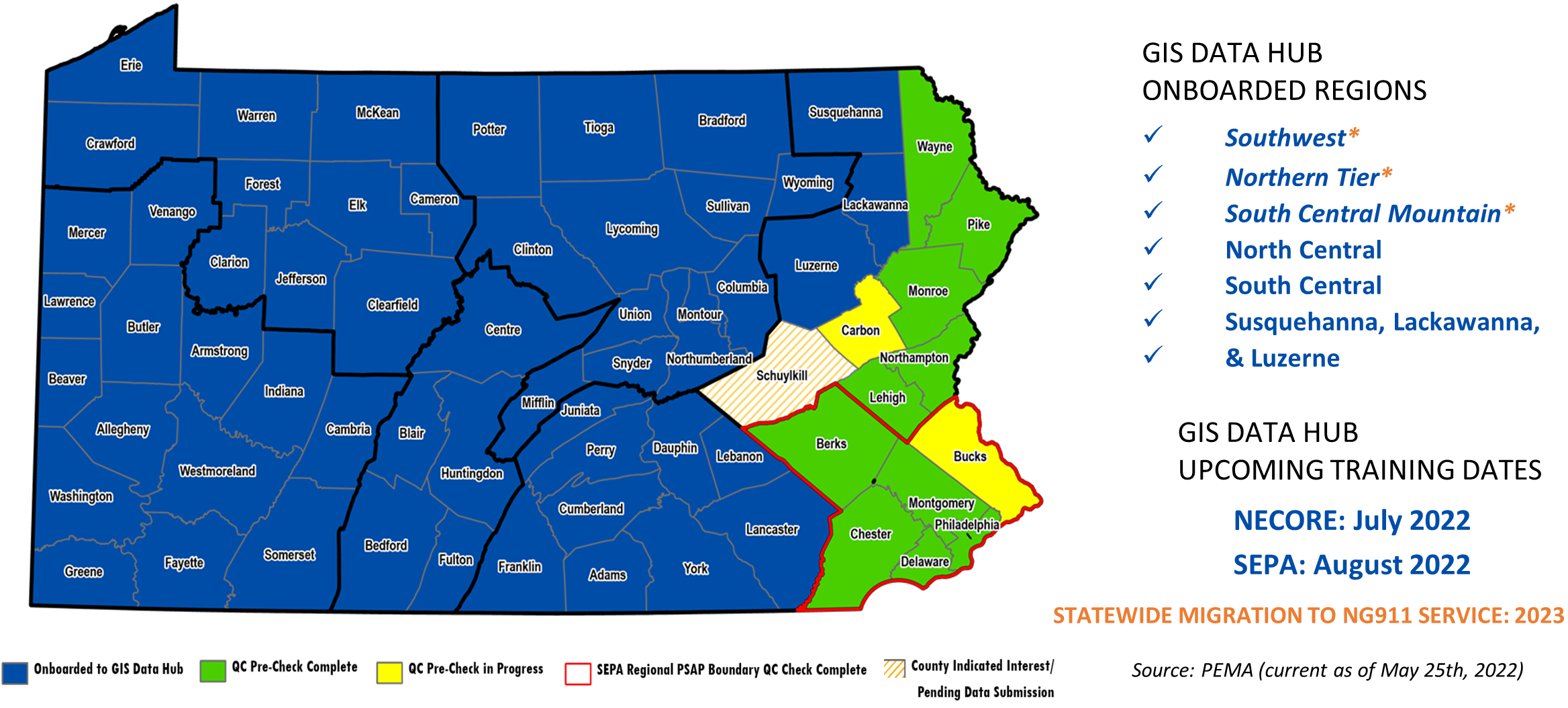
Figure 3. PA NG911 GIS Data Hub onboarding and QC pre-check status, PEMA (current as of 5/25/2022).
Long Description
Pennsylvania DOT (PennDOT) manages three sets of linearly referenced roads data―State-owned roads, liquid fuel roads, and non-liquid fuel roads. Almost all local roads are owned by the municipalities. Liquid fuel roads are local roads that meet specific criteria, and the road mileage is included in the calculation of the State’s gas tax. Funds are then distributed to the municipality roadway owners. PennDOT’s road and other GIS data are published on Open Data.
PennDOT would like to use the NG911 data to update their data with street names and other attributes. Ideally, they would like to eventually have full integration with a single road centerline dataset, though there are issues with ownership and stewardship of State-owned and liquid fuel roads because these roads involve financials. PennDOT does not maintain the local roads, but they would like to integrate these roads into their dataset in exchange for other information they can offer the municipalities.
To explore the feasibility of a single road centerline dataset, PennDOT participated in an AEGIST Pooled Fund pilot project using data from eight counties. Several comparisons and analysis between road datasets were undertaken in this effort. They included comparing road names between PennDOT data, county data, and NG911 data as well as comparing road alignment of NG911 centerline geometry with PennDOT roads. A record count and proximity analysis were applied to the data using different tolerances to determine how well the data compared and which tolerance would be more feasible to use to update a dataset. The data geometry was also compared at a micro level to use conflation to snap the PennDOT road to the local road data and compared to assign road ratings (Figure 4). Other comparisons between PennDOT data and local road data were documented including dual carriageways, divided highways, roundabouts, and the different ways of modeling intersections. One of the documents produced by the study was the creation of a chart comparing the modeling rules of AEGIST, PennDOT, PA NG911, and other States.
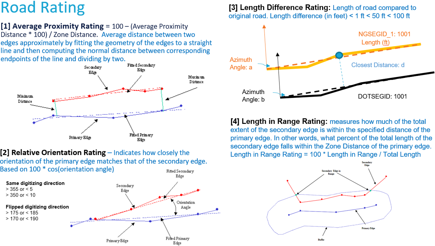
Figure 4. AEGIS Pooled Fund – road comparison to assign road ratings, PennDOT, AEGIST 2022.
Long Description
One of PennDOT’s biggest concerns regarding creating one common road centerline dataset is liability and ownership and stewardship of the data. For now, PennDOT may be willing to replace the non-liquid fuel roads with the updated roads from the municipalities and counties, but they will only be able to do this if the counties agree.
Alabama DOT
Alabama DOT (ALDOT) maintains the authoritative LRS line work for the State of Alabama, which is also used by other institutions such as academia, Alabama Law Enforcement (ALEA), and municipalities. ALDOT does all the updates to the road dataset since there is no State legislation that requires local agencies to submit road data to the State. This makes it difficult to update local roads. Only some of the larger counties send data to ALDOT, so the data for these counties are updated regularly.
The lack of updated local roads did not really become an issue until ALDOT’S safety initiative with creating an accurate crash database. This initiative is a collaboration with the Center for Advanced Public Safety (CAPS) at the University of Alabama. The police officers in the field were having problems locating crashes because the road data was not up to date. ALDOT is trying to get rid of their link and node legacy system and move to a system using mile points. It has not been possible to do this because police officers are used to seeing links and nodes, and it is used in their application to plot crashes for their report. The new system with CAPS is now synching the data nightly between ALDOT, CAPS, and ALEA, but it is not possible to totally get rid of the legacy system until all the local roads are up to date.
AL 911 Board is in the process of implementing the Alabama Next Generation Emergency Network (ANGEN). As of May 2021, the network buildout to the primary PSAPs is completed. The GIS project started in 2020. Seven mandatory GIS layers outlined in the NENA standards are being collected. All 85 datasets have now been collected from the local emergency communication districts. A two-phase process validates the data. First a pre-check is completed to make sure that everything needed to do the validation is present in the data received for the local authority. A report is created and sent to the district to do any updates. Then the data is run through the validation engine providing a more detailed report. Currently, each district is in various states of validation. (Figure 5) AL 911 is trying to build the GIS dataset so it is a network dataset with road centerline data that can be used for emergency response and for DOT and other State agencies, not just for 911 engineering and core services.
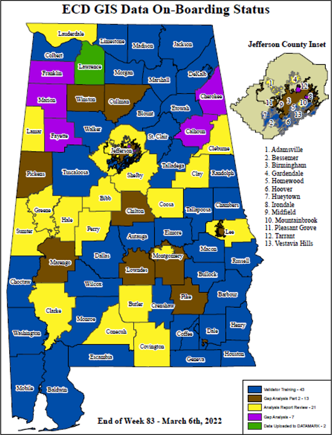
Figure 5. ECD GIS data on-boarding status, Alabama E911 Board, 06/2022.
Long Description
ALDOT is interested in getting the more authoritative road data from E911 Board since the data comes from local authorities that are the local addressing and road authority for the data. The preliminary idea would be to pull in data from the NG911 road database and assign it a flag. ALDOT and CAPS personnel could then go in and check the difference in the line work to a certain tolerance. They would especially look at functional class seven and use the NG911 line work based on functional class. Ultimately, they would like to pull in the NG911 data nightly, run it through their validation rules, and use the data to update their local roads.
Florida DOT
Before the Covid-19 pandemic, the Florida DOT was heavily involved with the kickoff of the NG911, with the Department of Management Services (DMS) creating an NG911 plan, so there is an implementation roadmap for NG911. The DMS sets policy for 911, but implementation is regional, or county-based. These initial steps included creating a Florida base map with county boundaries and Emergency Service Zones, creating a State repository, and surveying the 911 regions. The DOT coordination plans with DMS were slowed by the pandemic and due to poor coordination, collaboration, and communication with DMS, regions, State, and counties.
Florida has a Geospatial Information Officer (GIO) who coordinates with all the agencies in Florida. Another way Florida DOT coordinates with DMS is through Florida’s crash mapping system, which uses one road dataset first using Tele Atlas data, and the HERE data. The point addresses from this data were given by the GIO to the DMS to use for 911 addresses as another data source. DOT also has road data that could be used by DMS for NG911 to fill in their data. DMS has started up their NG911 activity again with statewide coordination, but DOT has not recently been involved in the process.
Idaho Transportation Department
The Idaho Transportation Department (ITD) does not currently have any coordination or communication with the Idaho E911 coordinator regarding sharing road and address data. They are interested in learning from other States how they approached other departments to facilitate a relationship with good communication and collaboration on data issues. They also would like to learn more about the differences between city versus rural counties and how other States update, track, and edit addresses and road networks. ITD does have good collaboration with their local highway districts regarding their needs and issues, and some collaboration with the cities. They would like to improve their data collection efforts going forward, which includes collaborating with E911 to avoid duplication of data and developing one road network for the State.
Oregon DOT
Oregon DOT has several units involved with GIS: the Transportation Operations Center (TOCS) program, in the ITS work group, the GIS Unit, and the Road Inventory Classifications Services Unit (RICS). Other State agencies that the ODOT partners with include the Department of Administrative Services (DAS-GEO), the Portland Dispatch Control Center (PDCC), the Oregon State Police, and the Office of Emergency Management (OEM). The 911 program is within OEM, as well as an NG911 program that is being developed.
TOCS has four locations across the State and is responsible for functions associated with emergency response such as incident response, management, communication, and dispatch. They support maintenance and coordination with other emergency services in the State and are involved with the NG911 effort regarding geolocating and routing. When a call comes in from the police it is routed to a center and geolocated. This latitude/longitude point is then connected to a highway LRS and then a mile point, which is then dispatched to first responders as an address taken from an address repository. There are some issues with the geolocating not being accurate enough, especially in metro areas, which on occasion can cause responders to be given a location on the opposite side of the median. TOCS has been collaborating with PDCC to improve their techniques and methods for geocoding and routing for the Portland area 911 calls. They are investigating methods for moving away from using XY and mileposts to using address data for geolocating. PDCC is also in the process of fusing several hubs in the metro area into one dispatch hub and ODOT may be a participating agency in these efforts. The next question is how the updated geocoding and routing methods can be expanded throughout the State.
ODOT is interested in improving their statewide road centerline data to include more local roads and for meeting ARNOLD reporting requirements, including updating Facility Type and Ownership data. Becoming part of the NG911 workflow could help with this project.
Roundtable #2 – Topics of Interest
In MN, the NG911 reached out to DOT to determine their needs and those elements were added to the State standards. In that way the data meets both the needs of 911 and DOT so locals can report at once.
The second roundtable discussed some of the reasons the State DOTs are interested in working with agencies involved with NG911 activities. Also discussed were what issues have come up in the collaborations and strategies to deal with issues. These discussions are outlined below.
- Some States are interested in collaborating with NG911 and local partners to update their road database because they need to update the local roads as required by ARNOLD and HPMS. These roads are usually maintained and updated at the local level.
- States need to collect addresses for different purposes including geocoding. States collect this data in various ways. Arizona collects this data from the Arizona motor vehicles division twice a year and they geocode the addresses (12 million) for an address layer. They provide these points back to the motor vehicle department and a metropolitan planning organization that is involved with an air quality study. They have used Tele Atlas geocoder, which is not very accurate. They are hoping to get the address points from the NG911 program, which is likely to be more accurate. Florida DOT believes that NG911 would be better off using the LRS data from the DOT because they have been good stewards of their data. In any case, it is important to have accurate address data for many purposes, which will be discussed during the NAD presentation.
- USPS postal codes would also be an important addition for generating an accurate address data layer. USPS does have a tool to make sure an address is postally correct, and they have an API application to verify zip codes. There would possibly also be a role for the Census Bureau and TIGER data. Working and coordinating with these groups is important for an accurate address database and will be discussed in the NAD presentation.
- Make sure data is public and shareable. Everyone wants to own their own data. You can update your own data, which you cannot do with third-party data, and be transparent about what work you are doing to create partnerships for collaboration.
- Communication and close coordination are necessary for partnerships between State DOTs and NG911 and local agencies. Some ways to foster this collaboration are:
- Having a State-level GIO involved is essential. The State GIO has communication with all agencies involved with GIS activities and knows all the contacts so is able to be able to bring people together. If there is no GIO, figure out who each person is in an agency that can help in the collaboration.
- Have legislation that defines the partnerships and what the agencies’ requirements involve.
- Have funding incentives attached to the work.
- Emphasize the benefits of the partnership and how it will create better data.
- Have a repository of data that is public and shareable. Being transparent about what work an agency is doing is important to create partnerships for collaboration.
- Create a communication plan to establish coordination.
- Establish how to verify and update data between agencies. It is important to establish guidelines to update one road network with the data from another network. One way would be to use a portal to compare and validate datasets. Have an exchange standard to share data such as road centerlines and addresses, so it makes it easy for the partners to collaborate. Also have an agreement to give updated data back to the original owners.
Back to Top
Day Three Activities
USDOT, Office of Chief Information Officer: The National Address Database E911/NG911
A presentation on the NAD was given by Steven Lewis, the USDOT’s Office of Chief Information officer. The NAD is an authoritative dataset of address point data that was started in 2016 and is housed at the USDOT. The address data is collected from State (36), local government (27), and Tribal partners (2) who have agreed to participate in the program. These partners are the official owners of their data, not the USDOT. When a State has not agreed to be a partner, some local governments in that State have agreed to partner directly with the NAD. States who are not yet partners in the endeavor may be facing issues such as State legislation regarding data being made public, receiving permission from cities and counties to share the data, or some local governments selling their data, so they do not want to make it public.
The NAD currently contains 65.3 million records. The database schema follows the NG911 standards developed by NENA standards and includes basic data elements that make partner compliance possible. (Figure 6) The point location of the data is usually the rooftop of a building, but the schema does include an attribute to describe the point location if it is not a rooftop. Besides the street address, the database also includes the latitude and longitude and national grid coordinates of the location point.
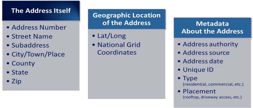
Figure 6. National Address Database schema, NENA standards.
Long Description
Some examples of NAD users include the Federal Emergency Management Agency (FEMA) and Google Maps. FEMA has used the database for disaster relief efforts. Google Maps has used the database to update their database and has stated to USDOT that it has helped them update thousands of records. The USPS has also used the data to verify their database. The NAD is currently trying to receive feedback from Google Maps on their updates, and to receive the official postal zip codes from USPS.
An updated version of the NAD is published every three months. The database can be downloaded as a file geodatabase or flat text file. Three national maps displaying the States are included with each download: a map showing the committed partners by State; a map showing the completion of submissions by State (Figure 7); and a map showing the age of the data by State. A web feature service is also available, which is best displayed at the local level on a map since the database is too large to display at a smaller scale.
The future of the NAD includes the development of an ArcGIS Portal, which will provide multiple download options. The NAD is also working with ESRI to produce a Story Map of the history and status of NAD. A visualization tool is also being developed.
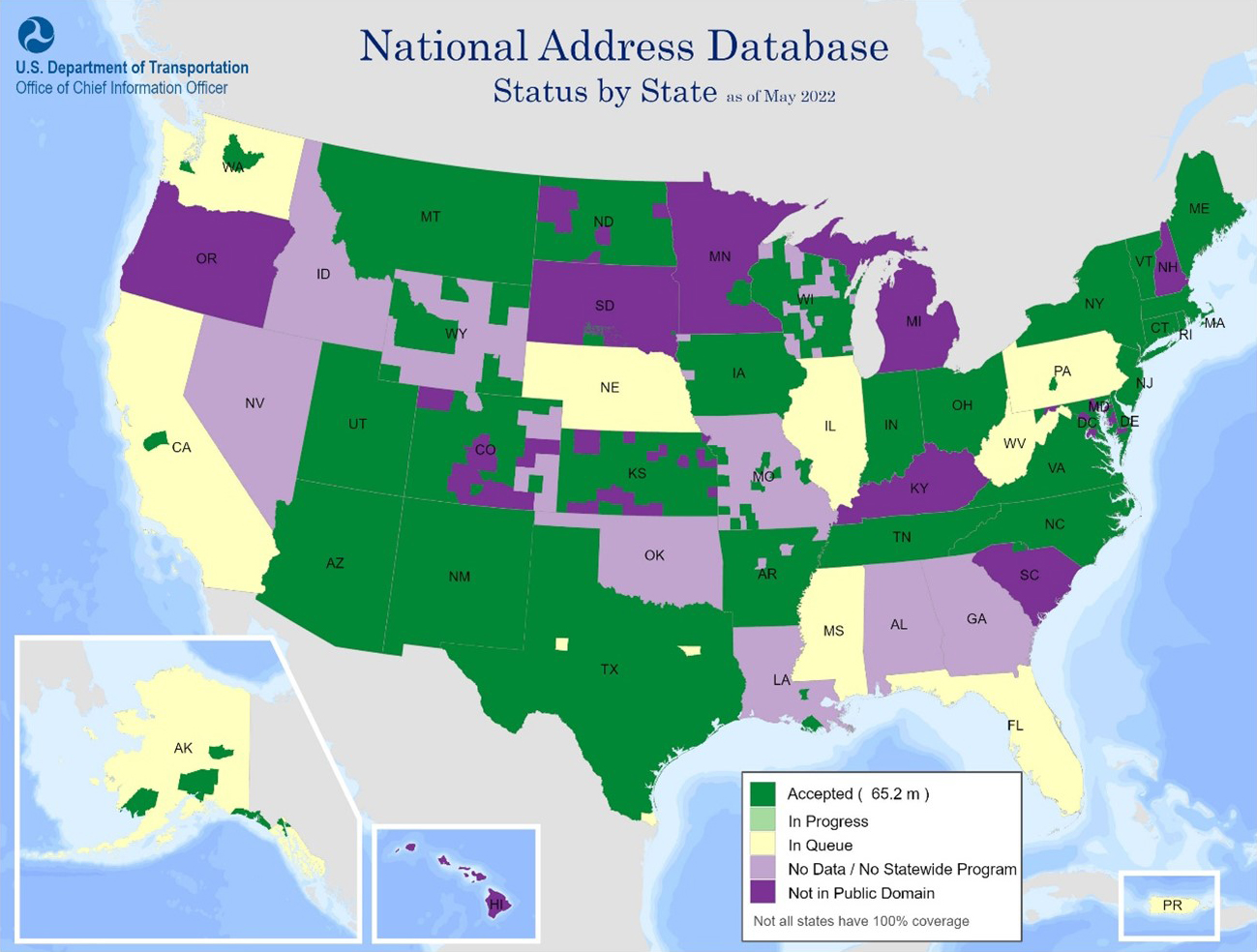
Figure 7. National Address Database, map of the status of State submissions. May 2022.
Long Description
NHTSA: National 911 Program
Kate Elkins from the Emergency Medical Services division of the National 911 Program office at NHTSA presented on the National 911 Program. Emergency systems are moving toward developing NG911, which involves using voiceover IP systems that will use GIS maps to route calls to the correct 911 center. Therefore, GIS mapping is a critical component of NG911, and it is important to have highly accurate GIS data that can be freely shared locally, regionally, and nationally. The National 911 Program’s goal is to develop a 911 GIS data-sharing strategic plan. Since regulations regarding #911 and emergency management are only at the State and local level, and not at the national level, the National E911 Program is not creating regulations. Instead, the Program has three tasks to help attain the goal of developing the strategic plan:
- Convene stakeholders to learn about their issues, make decisions, and take action.
- Create and share resources to help 911 programs and educate regarding 911 systems.
- Administer grants for updating State/local 911 systems (with the National Telecommunications and Information Administration (NTIA)).
Discussions with stakeholders regarding GIS mapping for NG911 are helping to identify gaps, capabilities, and challenges. The program is also conducting research on documents to find best practices. Three themes have emerged from these efforts: the need for a GIS data supply chain where local autonomy is maintained but with nationwide integration; issues with shortages of staff with the necessary GIS experience; and issues with funding for GIS needs from 911 funding and other sources.
The National 911 Program will produce several documents discussing what has been learned from its stakeholder meetings and research. Other project components that the program will undertake and share with States include:
- Creating a NG911 blueprint.
- Helping States understand how interstate interoperability needs to work regarding GIS data.
- Creating a document template for starting out with NG911.
- Providing formal support with conferences, strategic partnerships, and creating standards.
- Increasing Tribal support and inclusion in 911 programs.
The results of the National 911 Program will provide a national GIS data-sharing strategic plan with tools and resources to help State and local entities achieve their NG911 goals. (Figure 8) The program will continue to encourage collaboration between State DOT offices and their 911 counterparts.
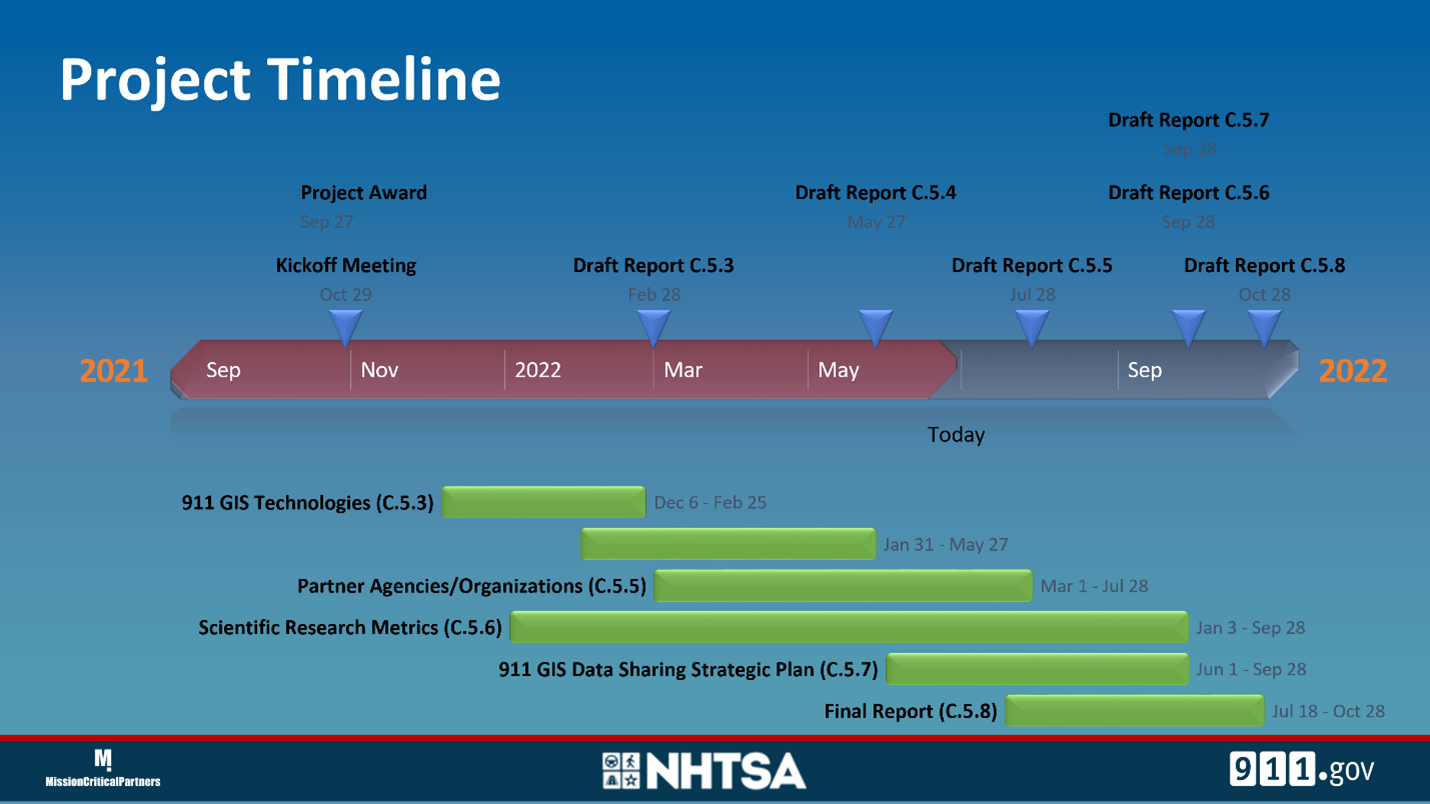
Figure 8. National 911 program timeline, 2022.
Long Description
Applications of Enterprise GIS in Transportation (AEGIST)
Joe Hausman, the AEGIST manager in the FHWA Office of Planning and Safety, presented on NG911 local and State DOT roads data integration. AEGIST was started in 2017 to develop a guidance document regarding linear reference, business rules, and data governance. It is a research effort to help States develop standardization for their road dataset and also to support HPMS. After the document was published a Pooled Fund Program was established. The FHWA’s Transportation Pooled Fund gives each participating State a $100,000 match to help the State start implementing the information in the guidance document. The funded projects focus on the States’ needs, and for some States the project involves NG911. Eighteen States are participating in the Pooled Fund with 13 already receiving the $100,000 match. (Figure 9) The ultimate goal is to try to get local entities and States to standardize road centerline data, including E911 data, and ultimately send it to FHWA for the development of a national road network. AEGIST also works with software vendors regarding data modeling, and to make software more compatible so data can be shared across different platforms.
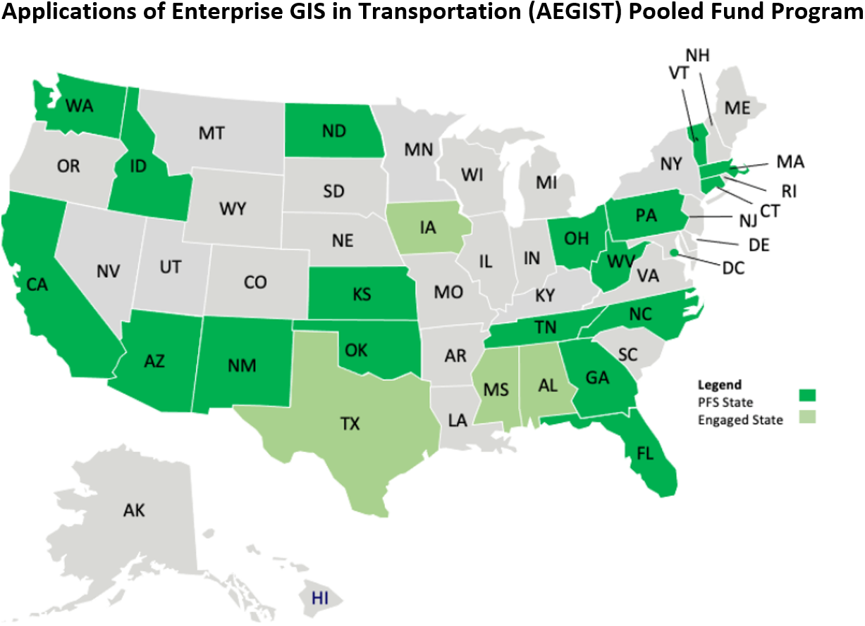
Figure 9. Applications of Enterprise GIS in Transportation (AEGIST) Pool Fund Program, NSGIC.
Long Description
Two State projects funded by the Pooled Fund Program are presented, Pennsylvania and California. In Pennsylvania, PennDOT maintains road data that it submits to FHWA to build ARNOLD. Pennsylvania counties maintain their own dataset of roads and they each may use different road models. The county data is being integrated to build the State’s NG911 roads dataset. This presented an opportunity to integrate the NG911 and ARNOLD dataset maintained by PennDOT. The NG911 dataset is useful to fill in the gaps in the PennDOT dataset and to figure out which roads are public or private. AEGIST helped in this collaboration with NG911. A small pilot project was developed using Cumberland County’s NG911 database and PennDOT’s road network to establish road centerline geometry alignment. Discussions involving this project deal with issues such as deciding which resolution should be used in the road centerline comparison, what are the different ways to conflate the roads to get one centerline, and to understand how the State and NG911 differ in modeling aspects of the datasets such as divided highways. These discussions and issues help to build modeling rules so everyone responsible for road datasets can work the same way. A final goal is to have the rules included in data-sharing agreements between State and local agencies. (Figure 10)
| Modeling Rule |
FHWA AEGIST |
PennDOT |
NG911 PA |
Other States |
|
Rule 1.1: Roads Data Model has following data entries (a) Centerline/Datum (b) Routes (c) Road Segments (i.e., NG911 Road Centerlines that break at junctions, see Rule 2.1) and (d) Centerline/Datum to Route Mapping. Route Geometry stored with Centerline/Datum and/or with Road Segments (Centerlines)
|
Yes |
Routes & RMS Segments defined. RMS Segments store geometry. May not break at junctions. |
Road Centerlines defined like Road Segments as they break at junctions and hold geometry. |
30+ State DOTs have (a), (b) and (d). Road Segments being created as part of AEGIST for MIRE. |
|
Rule 1.2: Route ID created for Routes and is set up as an intelligent Route(?) ID, typically with information about: County, Route Signage,
|
Yes |
Yes |
|
30+ States use Intelligent Route IDs. |
|
Rule 1.3: Roads are modeled with dual geometry routes (i.e., as divided highways, depending on median type, median length, median width, number of lanes, and/or based on different street name.
|
Median Type, Width, and Length |
Median Type, Width, Length, and Number of Lanes |
Median Type (Physical Barrier: Dual Geometry), Median Width, Length, Street Name |
Median Type, Width, and Length, as defined by FHWA HPMS-ARNOLD |
|
Rule 1.4: Information on overlapping routes on concurrent named roads is captured in the roads data model
|
Yes. Using “Overlap Segment ID” |
Yes |
Yes. Information captured in Street Name Alias Table |
Route Concurrency tables and rules configured in LRS |
|
Rule 1.5: Routes are Digitized in the Inventory (Cardinal) Direction
|
TBD |
TBD |
TBD |
TBD |
|
Rule 1.6: Routes should snap with each other and with boundary layers overshoots and undershoots are not allowed
|
TBD |
TBD |
TBD |
TBD |
|
Rule 1.7: Routes at Cul-de-sacs
|
TBD |
TBD |
TBD |
TBD |
|
Rule 1.8: Routes can have gaps in geometry, i.e., [unreadable] routes are allowed
|
TBD |
TBD |
TBD |
TBD |
|
Rule 1.9: Roads with same name, Assignment of Route IDs
|
TBD |
TBD |
TBD |
TBD |
|
Rule 1.10: Roads with two-way left turn lanes are modeled as single carriageway geometry routes (undivided routes)
|
TBD |
TBD |
Single road centerline when yellow stripes separate travel directions |
TBD |
Figure 10. Road information modeling rules comparison, AEGIST, FHWA Office of Planning and Safety.
The California Pooled Fund pilot project is called Cal Office of Emergency Services (OES) and is located in Merced County. Its purpose is for the GAO and Caltrans to work toward a standardized model for collecting local road data, and to create one road centerline dataset for the State. California’s road network originally used Tiger data for local roads and has been cleaning the local road data over the years. The Cal OES project is working with local governments and E911 to help in this effort. The project has engaged in discussions with local agencies including E911, to emphasize that road centerlines are used for multiple purposes for a variety of stakeholders. The project compares centerline data from the State and E911 county networks to understand where the problematic areas are in the State’s road network. The road data will be sent from the county level to the State where Caltrans will create one road centerline file that will then be sent back to local authorities to be used for multiple business processes.
Next steps for AEGIST regarding State road networks and NG911 are to help other States with their pilot projects. AEGIST also presents their work at a variety of national conferences and at meetings with States, local government, and Federal agencies.
Roundtable #3: Benefits of Interagency Cooperation and Conclusions
The third Roundtable was a discussion reiterating why it is important for State DOTs to work with their E911 agency, and what the benefits and issues are of this partnership. The State DOT needs to maintain all public roads, not just the State roads. A road network is used for many purposes such as crash location and asset management, as well as emergency management. For example, in Alabama, as in most States, the DOT road data is the authoritative road network in the State. Unfortunately, they do not have an efficient workflow at the local level to keep the local road data up to date. NG911 can be another source of the local road data in the State, which is one reason why collaboration between agencies is important.
The key to collaboration is communication. It is important to bring everyone to the table and to understand the others’ needs, as well as why a collaboration on a State road network can be beneficial to everyone. One way to bring the relevant agencies together is by leveraging the State GIO and NSGIC, entities that have relationships with all parties. During interagency discussions it is important to identify something tangible that each party can give and receive for an agency to justify the collaboration with their superiors. The steps to building one State road network start with understanding how the different partners can help each other, and how having one State road network can benefit the whole State.
Back to Top
Next Steps
The result of the E911/NG911 Peer Exchange is to create this document with the Peer Exchange summary and results. Future work will be presenting the topics reviewed at future conferences and working groups.
Back to Top
Appendix A: Peer Exchange Agenda
Tuesday, June 21, 2022
| Time (ET) |
Topic |
| 12:00-12:15 P.M. |
Welcome and Introductions
FHWA (Mark Sarmiento) welcomes attendees, reviews the agenda, and introduces GIS Program.
|
| 12:15-1:00 P.M. |
Roundtable: Short Introductions
Two or three topics interested in discussing. Why are they there? Why are we addressing this topic? Purpose and Goals of the Peer Exchange.
|
| 1:00-1:20 P.M. |
Presentation 1
Slides on answers to survey questions. Additional response to be added.
|
| 1:20-1:30 P.M. |
Break |
| 1:30-2:20 P.M. |
Presentation 2 with Q&A: Arizona DOT/E911 |
| 2:20-2:30 P.M. |
Break |
| 2:30-3:15 P.M. |
Presentation 3 with Q&A: Ohio DOT/E911 |
| 3:15-3:30 P.M. |
Summary and Wrap-up |
| 3:30 P.M. |
Adjourn |
Thursday, June 23, 2022
| Time (ET) |
Topic |
| 12:00-12:15 P.M. |
Introduction and Agenda Review
Mark Sarmiento, FHWA
|
| 12:15-12:50 P.M. |
Presentation 1: Pennsylvania |
| 12:50-1:05 P.M. |
Presentation 2: Alabama |
| 1:05-1:15 P.M. |
Break |
| 1:15-1:30 P.M. |
Presentation 3: Florida |
| 1:30-1:45 P.M. |
Presentation 4: Idaho |
| 1:45-2:00 P.M. |
Presentation 5: Oregon |
| 2:00-2:10 P.M. |
Break |
| 2:10-3:00 P.M. |
Roundtable
Discuss issues such as collaboration/coordination, funding, road network/local streets/conflation, cover survey question issues.
|
| 3:00-3:30 P.M. |
Summary and Wrap Up |
| 3:30 P.M. |
Adjourn |
Friday, June 30, 2022
| Time (ET) |
Topic |
| 12:00-12:10 P.M. |
Introduction and Agenda Review
Mark Sarmiento, FHWA
|
| 12:10-12:50 P.M. |
Presentation 1 with Q&A: National Address Database |
| 12:50-1:30 P.M. |
Presentation 2 with Q&A: NHTSA National 911 Program |
| 1:30-1:40 P.M. |
Break |
| 1:40-2:20 P.M. |
Presentation 3 with Q&A: Applications of Enterprise GIS in Transportation (AEGIST) |
| 2:20-2:30 P.M. |
Break |
| 2:30-3:15 P.M. |
Roundtable
What resources are needed to address the issues? What do the State DOTs need from FHWA and others? Do they need a working group to share?
|
| 3:15-3:30 P.M. |
Summary, Wrap-up, and Next Steps |
| 3:30 P.M. |
Adjourn |
Back to Top
Appendix B: Peer Exchange Participants
Back to Top

